Kingfisher Tower (Utah)

Last updated
Kingfisher Tower
Fisher Towers area, near Moab, Utah (6293971315).jpg
South aspect
Highest point
Elevation 6,794 ft (2,071 m) [1]
Prominence 520 ft (158 m) [2]
Parent peak The Titan [2]
Isolation 0.40 mi (0.64 km) [2]
Coordinates 38°43′23″N109°18′04″W / 38.723042°N 109.30112°W / 38.723042; -109.30112 [3]
Geography
USA Utah relief location map.svg
Red triangle with thick white border.svg
Kingfisher Tower
Location in Utah
Usa edcp relief location map.png
Red triangle with thick white border.svg
Kingfisher Tower
Kingfisher Tower (the United States)
CountryUnited States
State Utah
County Grand
Parent range Colorado Plateau [3]
Topo map USGS Fisher Towers
Geology
Mountain type Pillar
Type of rock Sandstone
Climbing
First ascent 1962
Easiest route class 5.8 Northeast Ridge [1]

Kingfisher Tower is a 6,794-foot-elevation (2,071-meter) pillar in Grand County, Utah, United States.

Contents

Description

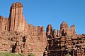
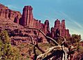
Kingfisher Tower is located 17 miles (27 km) northeast of Moab, Utah, on land administered by the Bureau of Land Management. Kingfisher is the second-highest peak in the Fisher Towers, [1] and it ranks as the 14th-steepest peak in the United States. [2] Topographic relief is significant as the summit rises nearly 600 feet (183 meters) above the tower's base, [1] and over 2,000 feet (610 meters) above the Fisher Towers Campground in 0.4 miles (0.64 km). Precipitation runoff from the tower drains to Onion Creek which empties into the Colorado River, approximately three miles to the west. Access is via Fisher Towers Road from Route 128.

Geology

Kingfisher Tower is set on a fin and is composed of two principal strata of sandstone and mudstone: Permian Cutler Formation capped by Early Triassic Moenkopi Formation. There is an unconformity between the Cutler and the Moenkopi layers. [4]

Climate

Spring and fall are the most favorable seasons to visit Kingfisher Tower. According to the Köppen climate classification system, it is located in a cold semi-arid climate zone with cold winters and hot summers. [5] Summers highs rarely exceed 100 °F (38 °C). Summer nights are comfortably cool, and temperatures drop quickly after sunset. Winters are cold, but daytime highs are usually above freezing. Winter temperatures below 0 °F (−18 °C) are uncommon, though possible. This desert climate receives less than 10 inches (250 millimeters) of annual rainfall, and snowfall is generally light during the winter.

Climbing

The first ascent of the summit was made May 27–31, 1962, by Harvey T. Carter and Cleve McCarty via the class 5.8 Northeast Ridge. [1]

Rock climbing routes on Kingfisher Tower: [6]

See also

Related Research Articles

<span class="mw-page-title-main">The Titan (Fisher Towers)</span> Mountain in United States of America

The Titan is a 6,112-foot-elevation (1,863-meter) pillar in Grand County, Utah, United States.

<span class="mw-page-title-main">Bridger Jack Butte</span> Rock formation in Utah, United States

Bridger Jack Butte is a sandstone butte located in Bears Ears National Monument, in San Juan County, Utah, United States. Set at the northern tip of Bridger Jack Mesa and above the confluence of Indian and Lavender Creeks, the summit rises to an elevation of 5,890 feet, and towers over 700 feet above the surrounding terrain and floor of Lavender Canyon to its west. This landmark is situated four miles southeast of the Sixshooter Peaks, and is visible from State Route 211 between Newspaper Rock and the Needles District of Canyonlands National Park. "Bridger Jack" was a Paiute medicine man.

<span class="mw-page-title-main">Three Gossips</span> Natural rock formation in Utah, US

The Three Gossips is a 4,700-foot-elevation (1,433-meter) sandstone pillar in Grand County, Utah, United States.

<span class="mw-page-title-main">Assembly Hall Peak</span> Mountain in Utah, United States

Assembly Hall Peak is a 6,395-foot-elevation (1,949-meter) summit in Emery County, Utah, United States.

<span class="mw-page-title-main">Eagle Mesa</span> Mountain in Utah, United States

Eagle Mesa is a 6,624-foot-elevation (2,019-meter) summit in San Juan County, Utah, United States.

<span class="mw-page-title-main">Castle Butte (Valley of the Gods)</span>

Castle Butte is a 5,700-foot-elevation (1,737-meter) summit in San Juan County, Utah, United States.

<span class="mw-page-title-main">Lady in the Bathtub</span>

Lady in the Bathtub is a 5,552-foot-elevation (1,692-meter) pillar in San Juan County, Utah, United States.

<span class="mw-page-title-main">Rooster Butte</span>

Rooster Butte is a 5,145-foot-elevation (1,568-meter) summit in San Juan County, Utah, United States.

<span class="mw-page-title-main">Battleship Rock</span>

Battleship Rock is a 5,422-foot-elevation (1,653-meter) summit in San Juan County, Utah, United States.

<span class="mw-page-title-main">Seven Sailors</span>

Seven Sailors is a 4,860-foot-elevation (1,481-meter) pillar in San Juan County, Utah, United States.

<span class="mw-page-title-main">De Gaulle and His Troops</span>

De Gaulle and His Troops is a 5,540-foot-elevation (1,689-meter) summit in San Juan County, Utah, United States.

<span class="mw-page-title-main">Adobe Mesa</span>

Adobe Mesa is a 7,475-foot-elevation (2,278-meter) summit in Grand County, Utah, United States.

<span class="mw-page-title-main">Argon Tower</span>

Argon Tower is a 4,750-foot-elevation (1,448-meter) pillar in Grand County, Utah. It is located within Arches National Park and like many of the rock formations in the park, Argon Tower is composed of Entrada Sandstone. The tower is 260 feet tall, and topographic relief is significant as the summit rises 450 feet vertically above the Park Avenue Trail in 400 feet laterally. Precipitation runoff from Argon Tower drains to the nearby Colorado River via Courthouse Wash. This landform was shown briefly in the opening scene credits of the 1989 American action-adventure film Indiana Jones and the Last Crusade.

<span class="mw-page-title-main">Three Penguins</span>

Three Penguins is a 4,488-foot-elevation (1,368-meter) summit in Grand County, Utah, United States.

<span class="mw-page-title-main">Tower of Babel (Utah)</span>

Tower of Babel is a 4,655-foot-elevation (1,419-meter) summit in Grand County, Utah. It is located within Arches National Park and like many of the rock formations in the park, it is composed of Entrada Sandstone. The tower is 500 feet tall, and topographic relief is significant as the summit rises 500 feet vertically above the main park road in approximately 200 feet laterally. Precipitation runoff from Tower of Babel drains to the nearby Colorado River via Courthouse Wash. This landform's descriptive toponym has been officially adopted by the United States Board on Geographic Names.

<span class="mw-page-title-main">The Organ (Arches National Park)</span>

The Organ is a 4,735-foot-elevation (1,443-meter) pillar in Grand County, Utah, United States

<span class="mw-page-title-main">Cottontail Tower</span>

Cottontail Tower is a 5,980-foot-elevation (1,823-meter) pillar in Grand County, Utah, United States.

<span class="mw-page-title-main">Ancient Art (Fisher Towers)</span>

Ancient Art is a 5,420-foot-elevation (1,652-meter) pillar in Grand County, Utah, United States.

<span class="mw-page-title-main">Echo Tower</span>

Echo Tower is a 5,784-foot-elevation (1,763-meter) pillar in Grand County, Utah, United States.

<span class="mw-page-title-main">The Oracle (Fisher Towers)</span> 6,060 ft sandstone tower in Utah

The Oracle is a 6,060-foot-elevation (1,847-meter) pillar in Grand County, Utah, United States.

References

  1. 1 2 3 4 5 Fred Beckey, Fred Beckey's 100 Favorite North American Climbs, Patagonia, 2013, ISBN   9781938340093.
  2. 1 2 3 4 "The Kingfisher - 6,020' UT". listsofjohn.com. Retrieved 2024-09-06.
  3. 1 2 "Kingfisher Tower, Utah". Peakbagger.com. Retrieved 2024-09-06.
  4. Castle Valley Overview United States of America, Virtual 3D Geoscience, v3geo.com, Retrieved 2024-09-05.
  5. Peel, M. C.; Finlayson, B. L. & McMahon, T. A. (2007). "Updated world map of the Köppen−Geiger climate classification". Hydrol. Earth Syst. Sci. 11 (5): 1633–1644. Bibcode:2007HESS...11.1633P. doi: 10.5194/hess-11-1633-2007 . ISSN   1027-5606. S2CID   9654551.
  6. Kingfisher Climbing, Mountain Project, Retrieved 2024-09-06.