The Titan (Fisher Towers)

Last updated
The Titan
The Titan aka Titan Tower at Fisher Towers, Utah.jpg
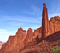
The Titan, south aspect
Highest point
Elevation 6,112 ft (1,863 m) [1]
Prominence 611 ft (186 m)Peak 6825 [1]
Parent peak Peak 6825 [2]
Isolation 0.56 mi (0.90 km) [2]
Coordinates 38°43′01″N109°17′58″W / 38.7170591°N 109.2995430°W / 38.7170591; -109.2995430 [3]
Geography
USA Utah relief location map.svg
Red triangle with thick white border.svg
The Titan
Location in Utah
Usa edcp relief location map.png
Red triangle with thick white border.svg
The Titan
The Titan (the United States)
CountryUnited States
State Utah
County Grand
Parent range Colorado Plateau [1]
Topo map USGS Fisher Towers
Geology
Age of rock Permian
Mountain type Pillar
Type of rock Sandstone
Climbing
First ascent 1962

The Titan is a 6,112-foot-elevation (1,863-meter) pillar in Grand County, Utah, United States.

Contents

Description

The Titan is located 17 miles (27 km) northeast of Moab, Utah, in the Fisher Towers, on land administered by the Bureau of Land Management. It is the largest of the Fisher Towers which are near Castle Valley. The Titan is the steepest peak in the United States. [4] It has also been attributed to be the largest, free-standing, natural tower in the United States. The tower contains the Finger of Fate Route, first climbed in 1962, which is recognized in the historic climbing text Fifty Classic Climbs of North America and considered a classic around the world. [5] [6] [7] [8] Topographic relief is significant as the summit rises 900 feet (274 meters) above the tower's base. Precipitation runoff from the tower drains to Onion Creek which empties into the Colorado River, approximately three miles to the west. Access is via Fisher Towers Road from Route 128 and hiking the Fisher Towers Trail. The Titan should not be confused with Titan Tower which is 0.8 mile to the east. [3] [9]

Climbing

The first ascent of the summit was made on May 13, 1962, by Layton Kor, Huntley Ingalls, and George Hurley via the class 5.8 Finger of Fate route. [10]

Rock-climbing routes on The Titan:

Geology

The Titan is composed of sandstone and mudstone of the Permian Cutler Formation with an Early Triassic Moenkopi Formation caprock. [18] There is an unconformity between the Cutler and the Moenkopi layers. [19] The reddish coloration of the rock is a result of varying amounts of hematite. [20]

Climate

Spring and fall are the most favorable seasons to visit The Titan. According to the Köppen climate classification system, it is located in a cold semi-arid climate zone with cold winters and hot summers. [21] Summers highs rarely exceed 100 °F (38 °C). Summer nights are comfortably cool, and temperatures drop quickly after sunset. Winters are cold, but daytime highs are usually above freezing. Winter temperatures below 0 °F (−18 °C) are uncommon, though possible. This desert climate receives less than 10 inches (250 millimeters) of annual rainfall, and snowfall is generally light during the winter.

See also

Related Research Articles

<span class="mw-page-title-main">Layton Kor</span> American rock climber

Layton Kor was an American rock climber active in the 1960s, whose first ascents and drive for climbing are well known in the climbing world. His routes included many climbs in Eldorado Canyon, near Boulder, Colorado, The Diamond on Longs Peak, towers in the desert southwest, and Yosemite National Park, among other locations. Notable among his first ascents is the Kor-Ingalls Route on Castleton Tower and The Finger of Fate Route up the Fisher Towers' Titan; both routes are recognized in the historic climbing text Fifty Classic Climbs of North America.

<span class="mw-page-title-main">Fisher Towers</span> Mountain in Grand County, Utah, United States

Fisher Towers are a series of towers made of Cutler sandstone capped with Moenkopi sandstone and caked with a stucco of red mud located near Moab, Utah. The Towers are named for a miner who lived near them in the 1880s. The Towers are world-renowned as a subject for photography and for its classic rock climbing routes.

<span class="mw-page-title-main">Finger of Fate (Fisher Towers)</span> Rock climbing route in Moab, Utah

Finger of Fate is a big wall aid climbing route located in Moab, Utah, on the Titan, the tallest of the Fisher Towers. It was first climbed in 1962. The route saw its first clean ascent in 1996 by Stevie Haston and Laurence Gauoult. The route is recognized in the historic climbing text Fifty Classic Climbs of North America and is considered a classic around the world.

<span class="mw-page-title-main">The West Temple</span> Mountain in the state of Utah

The West Temple is a prominent 7,810-foot mountain summit composed of Navajo Sandstone in Zion National Park in Washington County of Utah, United States. The West Temple, the highest feature in Zion Canyon, was originally called "Temp-o-i-tin-car-ur" meaning "Mountain without a trail" by the Paiute people. It was called Steamboat Mountain by local Mormon settlers before 1934, when the USGS officially changed it to its present name, which was applied by John Wesley Powell during his explorations in 1872. West Temple is situated two miles northwest of Springdale, Utah, one mile northeast of Mount Kinesava, and two miles west of the park headquarters. It is one of the notable landmarks in the park. The nearest higher peak is Windy Peak, 10.46 miles (16.83 km) to the north. Precipitation runoff from the mountain drains into tributaries of the Virgin River.

<span class="mw-page-title-main">Three Marys (Zion National Park)</span> 3 sandstone pillars in the state of Utah

Three Marys are three sandstone pillars in Zion National Park in Washington County, Utah, United States.

<span class="mw-page-title-main">Washer Woman</span> Sandstone arch and tower in Utah, US

Washer Woman is a 500-foot (150-meter) tall sandstone arch and tower located in the Island in the Sky District of Canyonlands National Park, in San Juan County, Utah. It is situated 300 feet northwest of the slightly higher Monster Tower. Washer Woman is so named because the feature gives the appearance of a washerwoman bent over a washtub. This geographical feature's name was officially adopted in 1986 by the U.S. Board on Geographic Names after previously having similar names such as Washer-Woman Arch and The Washer Woman. Washer Woman and Monster Tower are an eroded fin composed of Wingate Sandstone, which is the remains of wind-borne sand dunes deposited approximately 200 million years ago in the Late Triassic. Airport Tower is set 1.6 mi (2.6 km) to the east, and Mesa Arch is situated 1.5 mi (2.4 km) to the west. A short hike to Mesa Arch provides the easiest view of Washer Woman. Access to this formation is via the four-wheel drive White Rim Road, which is the other option to see it. The top of this geological formation rises 1,300 feet above the road in approximately one mile. Precipitation runoff from Washer Woman drains southeast into the nearby Colorado River via Buck Canyon.

<span class="mw-page-title-main">The Castle (Capitol Reef National Park)</span> Summit in the state of Utah, U.S.A.

The Castle is a 6,387-foot (1,947 m) summit in Capitol Reef National Park in Wayne County, Utah, United States. This iconic landmark is situated 0.5 mi (0.80 km) immediately north of the park's visitor center, towering nearly 800 feet (240 m) above the center and Utah State Route 24. Precipitation runoff from this feature is drained by tributaries of the Fremont River.

<span class="mw-page-title-main">Chimney Rock (Capitol Reef National Park)</span> Geological formation in the American state of Utah

Chimney Rock is a 6,420-foot (1,960 m) summit in Capitol Reef National Park in Wayne County, Utah, United States. This landmark is situated 2.5 mi (4.0 km) northwest of the park's visitor center, towering over 300 feet (91 m) above Utah State Route 24. Chimney Rock is also 2.5 mi (4.0 km) northwest of another of the park's landmarks, The Castle. Precipitation runoff from this feature ends up in the Colorado River drainage basin. The Chimney Rock Trail is a 3.5-mile loop trail that takes hikers to a view of Chimney Rock from above Mummy Cliffs.

<span class="mw-page-title-main">Sixshooter Peaks</span> Pair of summits in San Juan County, Utah, United States

The Sixshooter Peaks are two iconic sandstone summits located in Bears Ears National Monument in San Juan County, Utah, United States. The larger and higher North Sixshooter Peak rises to an elevation of 6,379 feet, whereas South Sixshooter Peak rises to 6,154 feet, with approximately 1.5 miles (2.4 km) separation between the two. These buttes tower nearly 1,400 feet above the surrounding terrain, and are historic landmarks visible from State Route 211 between Newspaper Rock and the Needles District of Canyonlands National Park. They are situated 1.5 mile outside the boundary of the park, and four miles northwest of Bridger Jack Butte. Variant names for the peaks include "North Six-Shooter Peak", "South Six-shooter Peak", "Six Shooter Peaks", and "Six-shooter Peak". They are so named because of their resemblance to a pair of revolvers pointing skyward.

<span class="mw-page-title-main">Bridger Jack Butte</span> Rock formation in Utah, United States

Bridger Jack Butte is a sandstone butte located in Bears Ears National Monument, in San Juan County, Utah, United States. Set at the northern tip of Bridger Jack Mesa and above the confluence of Indian and Lavender Creeks, the summit rises to an elevation of 5,890 feet, and towers over 700 feet above the surrounding terrain and floor of Lavender Canyon to its west. This landmark is situated four miles southeast of the Sixshooter Peaks, and is visible from State Route 211 between Newspaper Rock and the Needles District of Canyonlands National Park. "Bridger Jack" was a Paiute medicine man.

<span class="mw-page-title-main">Three Gossips</span> Natural rock formation in Utah, US

The Three Gossips is a 4,700-foot-elevation (1,433-meter) sandstone pillar in Grand County, Utah, United States.

<span class="mw-page-title-main">Finger of Fate (Idaho)</span> Pillar in Custer County, Idaho, United States

Finger of Fate is a 9,780-foot-elevation (2,981 m) pillar in Custer County, Idaho, United States.

<span class="mw-page-title-main">Eagle Mesa</span> Mountain in Utah, United States

Eagle Mesa is a 6,624-foot-elevation (2,019-meter) summit in San Juan County, Utah, United States.

<span class="mw-page-title-main">Kingfisher Tower (Utah)</span>

Kingfisher Tower is a 6,794-foot-elevation (2,071-meter) pillar in Grand County, Utah, United States.

<span class="mw-page-title-main">Tower of Babel (Utah)</span>

Tower of Babel is a 4,655-foot-elevation (1,419-meter) summit in Grand County, Utah. It is located within Arches National Park and like many of the rock formations in the park, it is composed of Entrada Sandstone. The tower is 500 feet tall, and topographic relief is significant as the summit rises 500 feet vertically above the main park road in approximately 200 feet laterally. Precipitation runoff from Tower of Babel drains to the nearby Colorado River via Courthouse Wash. This landform's descriptive toponym has been officially adopted by the United States Board on Geographic Names. This landform was shown briefly in the opening scene of the 1989 American action-adventure film Indiana Jones and the Last Crusade.

<span class="mw-page-title-main">Cottontail Tower</span>

Cottontail Tower is a 5,980-foot-elevation (1,823-meter) pillar in Grand County, Utah, United States.

<span class="mw-page-title-main">Ancient Art (Fisher Towers)</span>

Ancient Art is a 5,420-foot-elevation (1,652-meter) pillar in Grand County, Utah, United States.

<span class="mw-page-title-main">Echo Tower</span>

Echo Tower is a 5,784-foot-elevation (1,763-meter) pillar in Grand County, Utah, United States.

<span class="mw-page-title-main">The Oracle (Fisher Towers)</span> 6,060 ft sandstone tower in Utah

The Oracle is a 6,060-foot-elevation (1,847-meter) pillar in Grand County, Utah, United States.

<span class="mw-page-title-main">Sheep Rock (Arches National Park)</span>

Sheep Rock is a 4,564-foot-elevation (1,391-meter) pillar in Grand County, Utah. It is located within Arches National Park and like many of the rock formations in the park, it is composed of Entrada Sandstone, specifically the Slick Rock Member overlaying the Dewey Bridge Member. The tower is 440 feet tall, and is approximately 0.15 mile from the main park road. Sheep Rock is believed to be a remnant abutment of an ancient fallen arch. Precipitation runoff from Sheep Rock drains to the nearby Colorado River via Courthouse Wash. This landform's descriptive toponym has been officially adopted by the United States Board on Geographic Names.

References

  1. 1 2 3 "The Titan". Peakbagger.com. Retrieved 2024-09-14.
  2. 1 2 "Titan, The - 6,113' UT". listsofjohn.com. Retrieved 2024-09-14.
  3. 1 2 "The Titan". Geographic Names Information System . United States Geological Survey, United States Department of the Interior . Retrieved 2024-09-14.
  4. Contiguous US Steepness List, listsofjohn.com, Retrieved 2024-09-14.
  5. Roper, Steve; Steck, Allen (1979). Fifty Classic Climbs of North America . San Francisco: Sierra Club Books. pp. 217–220. ISBN   0-87156-292-8.
  6. McDonald, Dougald; Chris McNamara (2002). Desert Towers Select. Supertopo LLC.
  7. Bjornstad, Eric (1999). Desert Rock III. Helena, MO: Chockstone, Falcon. ISBN   1-56044-754-0.
  8. Knapp, Fred (2002). Classic Desert Climbs (second ed.). Sharp End Publishing. ISBN   1-892540-17-7.
  9. "Titan Tower". Geographic Names Information System . United States Geological Survey, United States Department of the Interior . Retrieved 2024-09-14.
  10. First Ascent Timeline, deserttowersbook.com, Retrieved 2024-09-14.
  11. Finger of Fate, Mountain Project, Retrieved 2024-09-14.
  12. Cameron Burns, Selected Climbs in the Desert Southwest: Colorado and Utah, The Mountaineers Books, 1999, ISBN   9780898866575, p. 78.
  13. Sundevil Chimney, Mountain Project, Retrieved 2024-09-14.
  14. Naked Lunch, Mountain Project, Retrieved 2024-09-14.
  15. World's End, Mountain Project, Retrieved 2024-09-14.
  16. Gimp Warfare, Mountain Project, Retrieved 2024-09-14.
  17. Jade Gate, Mountain Project, Retrieved 2024-09-14.
  18. Castle Valley Overview United States of America, Virtual 3D Geoscience, v3geo.com, Retrieved 2024-09-05.
  19. Castle Valley Overview United States of America, Virtual 3D Geoscience, v3geo.com, Retrieved 2024-09-05.
  20. GeoSights: Fisher Towers – The towering red rock sculptures of Grand County, Utah, Carl Ege, Utah Geological Survey, Retrieved 2024-09-12.
  21. Peel, M. C.; Finlayson, B. L. & McMahon, T. A. (2007). "Updated world map of the Köppen−Geiger climate classification". Hydrol. Earth Syst. Sci. 11 (5): 1633–1644. Bibcode:2007HESS...11.1633P. doi: 10.5194/hess-11-1633-2007 . ISSN   1027-5606. S2CID   9654551.