Marayong is a suburb of Sydney, in the state of New South Wales, Australia. Marayong is located approximately 32 kilometres north west of the Sydney central business district, in the local government area of the City of Blacktown and is part of the Greater Western Sydney region.
Torrens Park is a mainly residential large inner-southern suburb of Adelaide, incorporating some of the foothills and adjacent to the original "Mitcham Village". It was named after Sir Robert Richard Torrens, the instigator of the Torrens title system of land registration and transfer, who built a large home in the area which he named Torrens Park.

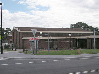
Goodwood is an inner southern suburb of the city of Adelaide, South Australia. It neighbours the Royal Adelaide Showgrounds and features several churches in its commercial district. Its major precinct is Goodwood Road, which is home to many shops, businesses and a library, as well as the local state school.

The City of Mitcham is a local government area in the foothills of southern Adelaide, South Australia. Within its bounds is Flinders University, South Australia's third largest, and the notable, affluent suburb of Springfield which contains some of the city's most expensive properties.

Kings Park is a suburb of Sydney, in the state of New South Wales, Australia. Kings Park is located 40 km west of the Sydney central business district, in the local government area of the City of Blacktown and part of the Greater Western Sydney region.

Unley is an inner-southern suburb of Adelaide, South Australia, within the City of Unley. The suburb is the home of the Sturt Football Club in the South Australian National Football League (SANFL). Unley neighbours Adelaide Park Lands, Fullarton, Hyde Park, Malvern, Parkside and Wayville.
Westbourne Park is an inner southern suburb of Adelaide, the State capital of South Australia. The suburb was named after Westbourne, a village in Sussex, England, and was laid out in 1881.
Greenhill Road is a major road in Adelaide, South Australia, that provides a connection to the eastern and hills suburbs. Its western section, running along the south side of Adelaide Parklands, forms part of Adelaide's City Ring Route.

Parkside is an inner southern suburb of Adelaide, South Australia. It is located in the City of Unley.

Clarence Park is an inner southern suburb of Adelaide, South Australia in the City of Unley. Its borders are Mills Street (north), Goodwood Road (east), Cross Road (south) and the Seaford railway line (north-west).

Black Forest is an inner southern suburb of Adelaide, South Australia. It is located in the City of Unley, bounded by the Glenelg tram line (north-west), the Seaford railway line (south-east), South Road (west) and East Avenue (east).
Fullarton is an inner southern suburb of Adelaide, South Australia in the City of Unley.
Hyde Park is an affluent inner-southern suburb of Adelaide in the City of Unley.
Malvern is an inner-southern suburb of Adelaide in the City of Unley. It borders the suburbs of Unley and Parkside to the north, Highgate to the east, Kingswood to the south and Unley Park to the west.

Millswood is an inner-southern mainly residential suburb of Adelaide in the City of Unley. It was named after Scotsman Samuel Mills, who arrived in the colony in 1839.

Unley Park is a southern suburb of Adelaide in the City of Unley. Its postcode is 5061.

Unley is a single-member electoral district for the South Australian House of Assembly. Named after the suburb of the same name, it is the state's smallest electorate by area at just 14.1 km2 (5.4 sq mi). It is a suburban electorate in Adelaide's inner south, taking in the suburbs of Eastwood, Frewville, Fullarton, Glenside, Glenunga, Goodwood, Highgate, Hyde Park, Kings Park, Malvern, Myrtle Bank, Parkside, Unley, Unley Park and Wayville, as well as parts of Glen Osmond and Millswood.

Cross Road is a major arterial road that travels east–west through the inner southern suburbs of the Australian city of Adelaide. It is designated route A3.
Hawthorn is a suburb of Adelaide, South Australia, in the City of Mitcham. It is bounded to the north by Cross Road, to the south by Grange Road, to the west by Sussex Terrace and to the east by Belair Road. The Belair train line runs through the suburb. To the west is Westbourne Park, and to the east is Kingswood.
Kings Park is a suburb in Melbourne, Victoria, Australia, 19 km (12 mi) north-west of Melbourne Central Business District, located within the City of Brimbank local government area. Kings Park recorded a population of 8,203 at the 2021 census.

