Kokomo, Colorado

Last updated

Kokomo
Mining ghost town
Kokomo, Colorado historical marker.JPG
The Kokomo historical marker along State Highway 91
USA Colorado location map.svg
Red pog.svg
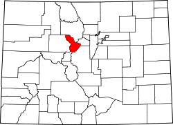
Kokomo
Location within the state of Colorado
Coordinates: 39°25′27″N106°11′23″W / 39.42417°N 106.18972°W / 39.42417; -106.18972
Country United States
State Colorado
County Summit
Elevation
10,695 ft (3,260 m)
Time zone UTC-7 (Mountain (MST))
  Summer (DST) UTC-6 (MDT)
ZIP codes
80424 [1]
GNIS feature ID179601 [2]

Kokomo is a silver- and gold-mining ghost town in Summit County, in the U.S. state of Colorado. [3] Before being depopulated in the 1960s, Kokomo was at its height home to over 10,000 people. [4]

History

The community took its name from nearby Kokomo Gulch which was named after Kokomo, Indiana. Some placer gold was discovered in the 1860s, but intensive mining did not begin until after the sharp increase of mining at Leadville in 1877. [5] A post office called Kokomo was established in 1879, and remained in operation until 1965. [6] A neighboring community, Recen, was heavily intertwined with Kokomo. The original town constructed of wood burned in 1879. [7] The town burned again in 1881, marking the beginning of decline and resulting in a merger with the community of Recen. [4] Also in 1881, the first Free Mason meeting was held, and a lodge was opened in 1882. A historical marker near the old townsite recognizes the lodge, which was existent until 1966. [5]

In the 1890s, Kokomo was at the highest elevation (10,618 feet) of any incorporated town in the state. [8] The town reached zero population in the 1960s when the land was bought by Climax Molybdenum Company to use as a tailings dump. [9]

Related Research Articles

<span class="mw-page-title-main">Rico, Colorado</span> Town in Colorado, United States

Rico is a town in Dolores County, Colorado, United States. It was settled in 1879 as a silver mining center in the Pioneer Mining District; today it functions as a historic and tourism site. The population was 288 at the 2020 census. Its current form of government is that of a home rule municipality.

<span class="mw-page-title-main">Oak Creek, Colorado</span> Town in Routt County, Colorado, United States

Oak Creek is a Statutory Town in Routt County, Colorado, United States. The population was 889 at the 2020 census.

<span class="mw-page-title-main">Uravan, Colorado</span> Uranium mining ghost town in Montrose County, Colorado

Uravan is a former uranium mining town in western Montrose County, Colorado, United States, which still appears on some maps. The town was a company town established by U. S. Vanadium Corporation in 1936 to extract the rich vanadium ore in the region. As a byproduct of vanadium extraction, small amounts of uranium were also produced, at the time mostly used as a yellow pigment for ceramics.

<span class="mw-page-title-main">Rollinsville, Colorado</span> Census-designated place in Gilpin County, Colorado, United States

Rollinsville is a census-designated place (CDP) and post office in and governed by Gilpin County, Colorado, United States. The CDP is a part of the Denver–Aurora–Lakewood, CO Metropolitan Statistical Area. The Rollinsville post office has the ZIP Code 80474. At the United States Census 2020, the population of the Rollinsville CDP was 194.

<span class="mw-page-title-main">Mount Antero</span> Mountain in Colorado, United States

Mount Antero is the highest summit of the southern Sawatch Range of the Rocky Mountains of North America. The prominent 14,276-foot (4351.4 m) fourteener is located in San Isabel National Forest, 12.2 miles (19.6 km) southwest by south of the Town of Buena Vista in Chaffee County, Colorado, United States. The mountain is named in honor of Chief Antero of the Uintah band of the Ute people.

<span class="mw-page-title-main">Caddoa, Colorado</span> Unincorporated community in State of Colorado, United States

Caddoa is an extinct town located in Bent County, Colorado, United States. The community takes its name from nearby Caddoa Creek.

<span class="mw-page-title-main">Segundo, Colorado</span> Census Designated Place in Colorado, United States

Segundo is an unincorporated community and a census-designated place (CDP) located in and governed by Las Animas County, Colorado, United States. The population of the Segundo CDP was 100 at the United States Census 2020. The Trinidad post office serves the area.

<span class="mw-page-title-main">Cuchara, Colorado</span> Unincorporated community in Huerfano County, Colorado, United States

Cuchara is an unincorporated community in Huerfano County, Colorado, United States. It is located near a former ski resort in the mountains south of the town of La Veta. Its altitude is 8,468 feet (2,581 m). State Highway 12 travels through Cuchara as it approaches Trinidad to the southeast.

<span class="mw-page-title-main">Valmont, Colorado</span> Census Designated Place in Colorado, United States

Valmont is an unincorporated community and a census-designated place (CDP) located in and governed by Boulder County, Colorado, United States. The CDP is a part of the Boulder, CO Metropolitan Statistical Area. The population of the Valmont CDP was 64 at the United States Census 2020. The land use consists of farming, low-density residential, some commercial, and a few school and church properties. The Boulder post office serves the area.

<span class="mw-page-title-main">Goldfield, Colorado</span> Census Designated Place in Colorado, United States

Goldfield is an unincorporated community and a census-designated place (CDP) located in and governed by Teller County, Colorado, United States. The CDP is a part of the Colorado Springs, CO Metropolitan Statistical Area. The population of the Goldfield CDP was 63 at the United States Census 2020. The Cripple Creek post office (Zip Code 80813) serves the area.

<span class="mw-page-title-main">Lulu City, Colorado</span> United States historic place

Lulu City was a transient mining town in eastern Grand County, Colorado, in the Kawuneeche Valley in what is now Rocky Mountain National Park. The town appeared after silver was discovered in the area in 1879 by prospector Joe Shipler, and was built primarily by the Middle Park and Grand River Land Improvement Company in 1880. The company was backed by Benjamin F. Burnett of Fort Collins and Fort Collins rancher William Baker. The town was named after Burnett's daughter. By 1881, there were forty cabins and a number of business establishments. By this time it was apparent that the silver ore was of low grade, and that high transportation costs made mining in the area marginal, and the town began its decline. It was abandoned by 1885, except by Shipler, who lived there for thirty years.

Cameo is an extinct coal mining town located in Mesa County, Colorado, United States. The townsite is located off I-70 Exit 46 at 39.1486°N 108.3209°W at an elevation of 4,787 feet (1,459 m).

Axial is an extinct coal mining town located in Moffat County, Colorado, United States.

<span class="mw-page-title-main">Bowen, Las Animas County, Colorado</span> Ghost town

Bowen is an extinct town located in Las Animas County, Colorado, United States.

Canfield is an unincorporated community in Boulder County, in the U.S. state of Colorado.

Kokomo Gulch is a valley in the U.S. state of Colorado.

Puritan is a former unincorporated community in Weld County, Colorado United States.

Tiger is an extinct town in Summit County, in the U.S. state of Colorado.

Tungsten is a ghost town in Boulder County, in the U.S. state of Colorado. The former townsite is north of Middle Boulder Creek.

<span class="mw-page-title-main">Parkville, Summit County, Colorado</span> Ghost town in Summit County, Colorado

Parkville is a ghost town located in, and the original county seat of, Summit County, Colorado, United States. Parkville was a gold mining camp that flourished from 1860 to 1866 near the confluence of the middle and south forks of the Swan River.

References

  1. "Kokomo (historical) in Summit County CO". CO HomeTownLocator. Retrieved March 10, 2020.
  2. "Kokomo, Colorado". Geographic Names Information System . United States Geological Survey, United States Department of the Interior. October 13, 1978. Retrieved March 10, 2020.
  3. U.S. Geological Survey Geographic Names Information System: Kokomo (historical)
  4. 1 2 Taylor, Jack (January 23, 2019). "Colorado Mining Towns: I Wanna Take You to Kokomo". 99.9 KEKB. Retrieved March 10, 2020.
  5. 1 2 "Kokomo Masonic Lodge". Historical Marker Database. September 6, 2017. Retrieved March 11, 2020.
  6. "Post offices". Jim Forte Postal History. Retrieved June 29, 2016.
  7. "KOKOMO and RACEN". Ghosttowns.com. Retrieved March 10, 2020.
  8. Dawson, John Frank. Place names in Colorado: why 700 communities were so named, 150 of Spanish or Indian origin. Denver, CO: The J. Frank Dawson Publishing Co. p. 30.
  9. "Kokomo Colorado". www.westernmininghistory.com. Retrieved September 7, 2016.