Leadville is a statutory city that is the county seat, the most populous community, and the only incorporated municipality in Lake County, Colorado, United States. The city population was 2,633 at the 2020 census. It is situated at an elevation of 10,119 feet (3,084 m). Leadville is the highest incorporated city in the United States and is surrounded by two of the tallest peaks in the state.

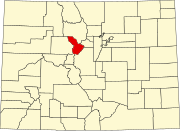
Summit County is a county located in the U.S. state of Colorado. As of the 2020 census, the population was 31,055. The county seat and largest town is Breckenridge.
Gold Hill is an unincorporated community and a census-designated place (CDP) located in and governed by Boulder County, Colorado, United States. The CDP is a part of the Boulder, CO Metropolitan Statistical Area. The population of the Gold Hill CDP was 218 at the United States Census 2020. The Boulder post office serves the area.

Ouray is a home rule municipality that is the county seat of Ouray County, Colorado, United States. The city population was 898 as of the 2020 census. The Ouray Post Office has the ZIP Code 81427. Located at an elevation of 7,792 feet (2,375 m), Ouray's climate, natural alpine environment, and scenery have earned it the nickname "Switzerland of America".
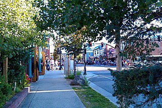
Breckenridge is a home rule municipality that is the county seat and most populous municipality of Summit County, Colorado, United States. The town population was 5,078 at the 2020 United States Census. Breckenridge is the principal town of the Breckenridge, CO Micropolitan Statistical Area. The town also has many part-time residents, as many people have vacation homes in the area. The town is located at the base of the Tenmile Range.

Swansea is a ghost town in La Paz County in the U.S. state of Arizona. It was settled circa 1909 in what was then the Arizona Territory. It served as a mining town as well as a location for processing and smelting the copper ore taken from the nearby mines.

Boreas Pass is a high mountain pass in central Colorado, in the Rocky Mountains of the western United States. The pass is located on the continental divide, at the crest of the Front Range along the border between Park (south) and Summit counties.

Dillon Reservoir, sometimes referred to as Lake Dillon, is a large fresh water reservoir located in Summit County, Colorado, United States, south of I-70 and bordered by the towns of Frisco, Silverthorne, and Dillon. It is a reservoir for the city of Denver, and its waters are under the control of Denver Water. Popular ski areas are close to the reservoir, including Copper Mountain, Keystone, Arapahoe Basin, and Breckenridge.
Arapahoe was one of the first settlements in what is now the U.S. state of Colorado. Nothing remains of the now deserted ghost town in Jefferson County, except a historical marker on the south side of 44th Avenue, between the cities of Golden and Wheat Ridge.
Eureka is an extinct mining town in San Juan County, Colorado, United States, along the Animas River, between Silverton and Animas Forks. The town derives its name from the Greek interjection Eureka! The Eureka post office operated from August 9, 1875, until April 30, 1942.
Gold mining in Colorado, a state of the United States, has been an industry since 1858. It also played a key role in the establishment of the state of Colorado.

Oro City is a ghost town in Lake County, Colorado, United States

Dyersville was a mining town — now a ghost town — in Summit County, Colorado, United States. It was named after Methodist minister John Lewis Dyer. Nothing remains of the town except the roofless walls of a couple of log cabins.
Grub Gulch is a former settlement in Madera County, California. The town's name was earned by its lucky reputation that prospectors could count on panning enough gold to "grubstake themselves into better times." It was located 10.5 miles (17 km) northeast of Raymond on present day Road 600.

Independence is an extinct town located in Pitkin County, Colorado, United States. It is located at an elevation of 10,913 feet (3,326 m) 2.2 miles (3.6 km) directly west of Independence Pass. It was the first settlement established in the Roaring Fork Valley, after gold was struck in the vicinity on Independence Day, July 4, 1879, hence its name. Independence was served by three differently named post offices: Farwell from July 14, 1881, until July 3, 1882; Sparkill from February 1, 1882, until October 18, 1887; and Chipeta from April 20, 1899, until October 17, 1899. It has also been known historically as Mammoth City, Mount Hope, and Hunter's Pass.
The Cripple Creek Gold Rush was a period of gold production in the Cripple Creek area from the late 1800s until the early 1900s. Mining exchanges were in Cripple Creek, Colorado Springs, Pueblo and Victor. Smelting was in Gillett, Florence, and (Old) Colorado City. Mining communities sprang up quickly, but most lasted only as long as gold continued to be produced. Settlements included:

Kokomo is a silver- and gold-mining ghost town in Summit County, in the U.S. state of Colorado. Before being depopulated in the 1960s, Kokomo was at its height home to over 10,000 people.

Bakerville is a mining ghost town in Clear Creek County, Colorado, United States. It is located west of modern-day Silver Plume, south of I-70 near the fourteener peaks of Grays and Torreys.

Guston is a silver mining ghost town in Ouray County, Colorado, United States, 11 miles (18 km) south of Ouray following the "Million Dollar Highway". Nestled in Champion Gulch, it is located near Red Mountain and the remnants of Red Mountain Town and Ironton. The Silverton Railroad ran from Guston in the Red Mountain Pass to Silverton in San Juan County. The silver mining camp was established in 1883. The Guston post office operated from January 26, 1892, until November 16, 1898.

Parkville is a ghost town located in, and the original county seat of, Summit County, Colorado, United States. Parkville was a gold mining camp that flourished from 1860 to 1866 near the confluence of the middle and south forks of the Swan River.