Tiger, Colorado

Last updated

Tiger
Mining ghost town
USA Colorado location map.svg
Red pog.svg
Tiger
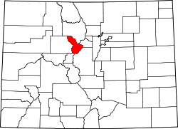
Location within the state of Colorado
Coordinates: 39°31′22″N105°57′44″W / 39.52278°N 105.96222°W / 39.52278; -105.96222
Country United States
State Colorado
County Summit
Elevation
9,669 ft (2,947 m)
Time zone UTC-7 (Mountain (MST))
  Summer (DST) UTC-6 (MDT)
ZIP codes
80424 [1]
GNIS feature ID203919 [2]

Tiger is an extinct town in Summit County, Colorado, United States.

A post office called Tiger was established in 1919, and remained in operation until 1940. [3] The community took its name from the Royal Tiger Mines Company. [4] The town site was destroyed before 1995 by the Forest Service in order to be used as a snowmobile track. [5]

Related Research Articles

<span class="mw-page-title-main">Yuma, Colorado</span> City in Colorado, United States

Yuma is a home rule municipality that is the most populous municipality in Yuma County, Colorado, United States. The population was 3,456 at the 2020 census.

<span class="mw-page-title-main">Rollinsville, Colorado</span> Census-designated place in Gilpin County, Colorado, United States

Rollinsville is a census-designated place (CDP) and post office in and governed by Gilpin County, Colorado, United States. The CDP is a part of the Denver–Aurora–Lakewood, CO Metropolitan Statistical Area. The Rollinsville post office has the ZIP Code 80474. At the United States Census 2020, the population of the Rollinsville CDP was 194.

<span class="mw-page-title-main">Shawnee, Colorado</span> Unincorporated community in Park County, Colorado, United States

Shawnee is an unincorporated community and post office in northern Park County, Colorado, United States, that is a historic district listed on the National Register of Historic Places (NRHP).

<span class="mw-page-title-main">Conejos, Colorado</span> Census Designated Place in Colorado, United States

Conejos is an unincorporated town, a post office, a census-designated place (CDP), and the county seat of Conejos County, Colorado, United States. The Conejos post office has the ZIP Code 81129. At the United States Census 2020, the population of the Conejos CDP was 46. Conejos is the only unincorporated county seat in the State of Colorado.

<span class="mw-page-title-main">Chromo, Colorado</span> Unincorporated community in State of Colorado, United States

Chromo is an unincorporated community and U.S. Post Office in Archuleta County, Colorado, United States. The Chromo Post Office has the ZIP Code 81128.

<span class="mw-page-title-main">Lazear, Colorado</span> Census Designated Place in Colorado, United States

Lazear is an unincorporated town, a census-designated place (CDP), and a post office located in and governed by Delta County, Colorado, United States. The Lazear post office has the ZIP Code 81420. The population was 168 at the 2020 census.

<span class="mw-page-title-main">Weldona, Colorado</span> Census Designated Place in Colorado, United States

Weldona is an unincorporated town, a post office, and a census-designated place (CDP) located in and governed by Morgan County, Colorado, United States. The CDP is a part of the Fort Morgan, CO Micropolitan Statistical Area. The Weldona post office has the ZIP Code 80653. At the United States Census 2020, the population of the Weldona CDP was 113.

<span class="mw-page-title-main">Segundo, Colorado</span> Census Designated Place in Colorado, United States

Segundo is an unincorporated community and a census-designated place (CDP) located in and governed by Las Animas County, Colorado, United States. The population of the Segundo CDP was 100 at the United States Census 2020. The Trinidad post office serves the area.

<span class="mw-page-title-main">Goldfield, Colorado</span> Census Designated Place in Colorado, United States

Goldfield is an unincorporated community and a census-designated place (CDP) located in and governed by Teller County, Colorado, United States. The CDP is a part of the Colorado Springs, CO Metropolitan Statistical Area. The population of the Goldfield CDP was 63 at the United States Census 2020. The Cripple Creek post office (Zip Code 80813) serves the area.

Adena is an extinct town located in Morgan County, Colorado, United States. The townsite is located at 40.0083°N 103.8866°W at an elevation of 4,692 feet (1,430 m).

Axial is an extinct coal mining town located in Moffat County, Colorado, United States.

Beshoar is an extinct town located in Las Animas County, Colorado, United States. The townsite is located at 37.2181°N 104.4066°W at an elevation of 5,922 feet (1,805 m).

<span class="mw-page-title-main">Bloom, Colorado</span> Ghost town

Bloom is an extinct town located in Otero County, Colorado, United States. The townsite is located at 37.6875°N 103.9566°W at an elevation of 4,800 feet (1,463 m).

<span class="mw-page-title-main">Bowen, Las Animas County, Colorado</span> Ghost town

Bowen is an extinct town located in Las Animas County, Colorado, United States.

Buckingham is an extinct town located in Weld County, Colorado, United States. The townsite is located at 40.6214°N 103.9777°W at an elevation of 4,944 feet (1,507 m).

<span class="mw-page-title-main">Haybro, Colorado</span>

Haybro,, is an extinct town in Routt County, Colorado, United States.

Iola is an extinct town located in Gunnison County, Colorado, United States. The community was inundated and destroyed by the creation of Blue Mesa Reservoir.

<span class="mw-page-title-main">Kokomo, Colorado</span> Ghost town in Summit County, Colorado

Kokomo is a silver- and gold-mining ghost town in Summit County, in the U.S. state of Colorado. Before being depopulated in the 1960s, Kokomo was at its height home to over 10,000 people.

Puritan is a former unincorporated community in Weld County, Colorado United States.

Tungsten is a ghost town in Boulder County, in the U.S. state of Colorado. The former townsite is north of Middle Boulder Creek.

References

  1. "Tiger, (historical) in Summit County CO". CO HomeTownLocator. Retrieved March 16, 2020.
  2. "Tiger, Colorado". Geographic Names Information System . United States Geological Survey, United States Department of the Interior. March 1, 1995. Retrieved March 10, 2020.
  3. "Post offices". Jim Forte Postal History. Retrieved July 11, 2016.
  4. Dawson, John Frank. Place names in Colorado: why 700 communities were so named, 150 of Spanish or Indian origin. Denver, CO: The J. Frank Dawson Publishing Co. p. 49.
  5. U.S. Geological Survey Geographic Names Information System: Tiger (historical)