Saints John, Colorado

Last updated

Saints John
Mining ghost town
Sts. John Colo around 1880.jpeg
View of Saints John around 1880
USA Colorado location map.svg
Red pog.svg
Saints John
Location within the state of Colorado
Coordinates: 39°34′18″N105°52′54″W / 39.57167°N 105.88167°W / 39.57167; -105.88167
Country United States
State Colorado
County Summit
Elevation
10,764 ft (3,281 m)
Time zone UTC-7 (Mountain (MST))
  Summer (DST) UTC-6 (MDT)
GNIS feature ID182364 [1]

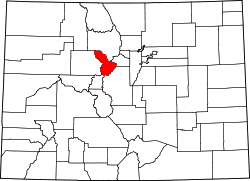
Saints John, originally called Coleyville and later Saint John, is a former silver-mining town in Summit County, Colorado. About a mile from the town of Montezuma, Saints John was the site of one of the first silver discoveries in Colorado. Although no longer a town, it still has several inhabitants.

Contents

History

A prospector named Coley discovered silver in 1863 or 1864 on the slope of Glacier Mountain, and built a crude furnace to extract silver from the ore. Other prospectors followed, including John Cullom, who discovered the Saints John Lode. In 1867, he sold the Saints John lode to the Boston Silver Mining Company, which built an ore mill, next to which grew the town, originally called Coleyville. [2] [3] The mining at Glacier Mountain was usually expensive and was burdensome upon the up to 50 townsfolk in the early years. [2] In the 1870 census, the town name had changed to Saints John by local Masons when it had a population of 71, which made it the largest incorporated town in Summit County. [4] [5]

The fortunes of the town followed those of the Saints John mine. The mine ceased working in 1928. [6] The remaining population of Saints John mostly transplanted to nearby Montezuma. Several structures remain, including the home of the mine's superintendent and the ruins of mining buildings. [4]

Geography

The site of Saints John is at 39°34′18″N105°52′54″W / 39.57167°N 105.88167°W / 39.57167; -105.88167 , at an altitude of 10,764 feet (3,281 m) above mean sea level. The site accessible by dirt road from Montezuma. [7] Saints John Creek flows through both the ghost town and present-day Montezuma.

Remains of the Saints John Mill in September 2022 The Saints John Mill at the Colorado Ghost Town of Saints John, in September 2022.jpg
Remains of the Saints John Mill in September 2022

See also

Related Research Articles

<span class="mw-page-title-main">Montezuma, Colorado</span> Town in Colorado, United States

The Town of Montezuma is a statutory town located in eastern Summit County, Colorado, United States. The town population was 74 at 2020 United States Census. The town is a former mining camp that sits at an elevation of 10,200 feet (3,110 m), just west of the Continental Divide, nestled among mountains that reach an elevation of 12,000-13,000 feet around it. It is situated in the upper valley of the Snake River above the ski resort of Keystone in the Rocky Mountains.

<span class="mw-page-title-main">Hillsboro, New Mexico</span> Unincorporated community & CDP in New Mexico, United States

Hillsboro is an unincorporated community in Sierra County, New Mexico, United States, located in the southwestern part of the state. It was founded in 1877, following the discovery of gold. The community was the county seat of Sierra County from 1884 until 1936, when Hot Springs became the county seat.

<span class="mw-page-title-main">Kennecott, Alaska</span> United States historic place

Kennecott, also known as Kennicott and Kennecott Mines, is an abandoned mining camp in the Copper River Census Area in the U.S. state of Alaska that was the center of activity for several copper mines. It is located beside the Kennicott Glacier, northeast of Valdez, inside Wrangell-St. Elias National Park and Preserve. The camp and mines are now a National Historic Landmark District administered by the National Park Service.

<span class="mw-page-title-main">Argentine Pass</span>

Argentine Pass, elevation 13,207 ft (4,025 m), is a high mountain pass that crosses the Continental Divide in the Front Range of the Rocky Mountains of central Colorado in the United States. Argentine Pass is located on the crest of the Front Range along the boundary southwest of Georgetown and is the highest named vehicle-accessible pass in the state.

<span class="mw-page-title-main">Gilman, Colorado</span> Town in Colorado, United States

Gilman is an abandoned mining town in southeastern Eagle County, Colorado, United States. The Gilman post office operated from November 3, 1886, until April 22, 1986. The U.S. Post Office at Minturn now serves Gilman postal addresses.

<span class="mw-page-title-main">Ashcroft, Colorado</span> Former mining town in Colorado, United States

Ashcroft is an extinct mining town located in Pitkin County, Colorado, United States. The silver mining camp was founded as Castle Forks City in the spring of 1880. A post office named Ashcroft operated at the site from August 12, 1880, until August 5, 1881, when the name was changed to Chloride. The Chloride post office operated until January 3, 1882 when the name was changed back to Ashcroft. The renamed Ashcroft post office finally closed on November 30, 1912.

<span class="mw-page-title-main">Ohio City, Colorado</span> Unincorporated community in Gunnison County, Colorado, United States

Ohio City is an unincorporated community and a U.S. Post Office in Gunnison County, Colorado, United States. The Ohio City Post Office has the ZIP Code 81237.

<span class="mw-page-title-main">Caribou, Colorado</span> Ghost town

Caribou is an extinct silver mining town located near Nederland in Boulder County, Colorado, United States. It was named after the Caribou silver mine nearby. The Caribou post office operated from January 31, 1871, until March 31, 1917. The Caribou Ranch recording studio was located several miles away, on the road from Nederland up to Caribou.

Dakan was a short-lived mining town, now a ghost town, in western Douglas County, Colorado, United States, in the Front Range of the Rocky Mountains. The Dakan post office operated from December 30, 1896, until August 2, 1898.

<span class="mw-page-title-main">Gold mining in the United States</span>

In the United States, gold mining has taken place continually since the discovery of gold at the Reed farm in North Carolina in 1799. The first documented occurrence of gold was in Virginia in 1782. Some minor gold production took place in North Carolina as early as 1793, but created no excitement. The discovery on the Reed farm in 1799 which was identified as gold in 1802 and subsequently mined marked the first commercial production.

Gold mining in Colorado, a state of the United States, has been an industry since 1858. It also played a key role in the establishment of the state of Colorado.

Silver mining in Colorado has taken place since the 1860s. In the past, Colorado called itself the Silver State.

Silver mining in Nevada, a state of the United States, began in 1858 with the discovery of the Comstock Lode, the first major silver-mining district in the United States. Nevada calls itself the "Silver State." Nevada is the nation's second-largest producer of silver, after Alaska. In 2014 Nevada produced 10.93 million troy ounces of silver, of which 6.74 million ounces were as a byproduct of the mining of gold. The largest byproducers were the Hycroft Mine, the Phoenix Mine, the Midas Mine and Round Mountain.

<span class="mw-page-title-main">Nevadaville, Colorado</span> American gold-mining town

Nevadaville was a gold-mining town in Gilpin County, Colorado, United States. It was also known in the 1860s and 1870s as Nevada City. The post office at Nevadaville was called the Bald Mountain post office, to avoid confusion with other Nevadas and Nevadavilles. The community is now largely a ghost town, although not completely deserted. The Nevadaville Masonic Temple that started in 1861 still holds regular meetings.

<span class="mw-page-title-main">Buckskin Joe, Park County, Colorado</span> Ghost town

Buckskin Joe is an extinct gold mining town located in Park County, Colorado, United States. The town was founded in 1860 as Laurette in what was then the Kansas Territory. The Territory of Colorado was created on February 28, 1861, and the Laurette post office opened on November 14, 1861. Laurette was elected the Park County seat on January 7, 1862. The post office name was changed to Buckskin on December 21, 1865, although the town was popularly known as Buckskin Joe. The county seat was moved to Fair Play in 1867, and the Buckskin post office closed on January 24, 1873.

<span class="mw-page-title-main">Castle Dome Landing, Arizona</span> Ghost town in Yuma County, Arizona

Castle Dome Landing, Arizona is a ghost town in the Castle Dome Mountains of Yuma County in the U.S. state of Arizona. It was first settled as a transport depot and mining camp around 1863 in what was then the Arizona Territory.

Poeville, also known as Peavine until 1863, is the site of a historical mining town, established in 1864. John Poe, a professional promoter from Michigan allegedly related to Edgar Allan Poe, discovered rich gold and silver veins in 1862 on the slopes of Peavine Mountain. After the discovery of ore, Poe announced that the veins comprised the next Comstock Lode; he presented extracted ore at the state fair of 1864 as rich in content. As a result, the former mining camp, called Poe City (Poeville) or Podunk (Poedunk), grew to 200 people by 1864. Ore production in the mining district and population peaked around 1873-1874 with several hundred people living in town, supported by three hotels and a post office. The post office, named "Poeville", operated between September 1, 1874, and March 24, 1878. As of 2010 the population of the community is 0.

<span class="mw-page-title-main">Juneau gold belt</span> Juneau gold belt buried deep underground mystery

The Juneau gold belt is located in the southeastern portion of the U.S. state of Alaska. This belt is approximately 100 miles (160 km) in length, north/northwest-trending, and extends from Berners Bay southeastward to Windham Bay, 60 miles (97 km) southeast of Juneau, and includes Douglas Island. The belt contains over 200 gold-quartz-vein deposits with production nearing 7,000,000 ounces (200,000,000 g) of gold. More than three-quarters of Alaska's lode gold was mined from the Juneau gold belt.

Potosi or Potosi Camp, was called Crystal City in the 1870s, a mining ghost town in Clark County, Nevada. It lies at an elevation of 5705 feet.

<span class="mw-page-title-main">Bonanza Peak (Alaska)</span> Mountain in Alaska

Bonanza Peak is a 6,983-foot mountain summit located in the Wrangell Mountains, in the U.S. state of Alaska. The peak was notable for its abundance of copper deposits which were mined from 1909 through 1938. The peak is situated in Wrangell-St. Elias National Park and Preserve, immediately northeast of Kennecott, 7 mi (11 km) northeast of McCarthy, 3.46 mi (6 km) north of Porphyry Mountain, and 5.2 mi (8 km) southeast of Donoho Peak. The confluence of the Kennicott and Root Glaciers lies below the mountain's west slope. Precipitation runoff from the mountain drains into tributaries of the Nizina River, which in turn is part of the Copper River drainage basin. The mountain's local name was reported in 1914 by the U.S. Geological Survey. On a clear day the summit of Bonanza Peak offers views of Sourdough Peak, Mount Blackburn, and Fireweed Mountain.

References

  1. "Saints John, Colorado". Geographic Names Information System . United States Geological Survey, United States Department of the Interior. October 13, 1978. Retrieved March 11, 2020.
  2. 1 2 Robert L. Brown, Jeep Trails to Colorado Ghost Towns (Caxton Press, 1963) 188-189.
  3. T. S. Lovering (1935) Geology and Ore Deposits of the Montezuma Quadrangle, Colorado, US Geological Survey, Professional Paper 178, p.66-67.
  4. 1 2 "St(s). John or Coleyville". Ghosttowns.com. Retrieved March 11, 2020.
  5. Ninth Census-Volume I, The Statistics of the Population of the United States (1872) p.96.
  6. T. S. Lovering (1935) Geology and Ore Deposits of the Montezuma Quadrangle, Colorado, US Geological Survey, Professional Paper 178, p.104.
  7. US Board of Geographic Names, Saints John, accessed 3 November 2010.