Manmad is one of the towns in Nashik district in the state of Maharashtra in India. It is the third largest city in Nashik district, with a population of approximately 80,000. Geographically it lies within Nandgaon Tehsil in Nashik District. Though it has a larger area and population than most Tehsils in the district, it does not have a Tehsil office.

The Bhima River is a major river in Western India and South India. It flows southeast for 861 kilometres (535 mi) through Maharashtra, Karnataka, and Telangana states, before entering the Krishna River. After the first sixty-five kilometers in a narrow valley through rugged terrain, the banks open up and form a fertile agricultural area which is densely populated.
Daund is a city, municipal council, and headquarters of the Daund tehsil in the Pune district in the state of Maharashtra, India. The city of Daund is located on the Bhima River.

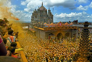
Jejuri is a city and a municipal council in the Pune district of Maharashtra, India. The town has an important mandir to the Hindu Lord Khandoba, the Khandoba Mandir, which is one of the most visited tirtha in Maharashtra.

Malhargad is a hill fort in western India near Saswad, 30 kilometres (19 mi) from Pune. It is also known as Sonori Fort due to the village of Sonori being situated at its base. The fort was named for the god Malhari and was the last fort built by the Marathas, in 1775.
The Karha is a river flowing through the Indian state of Maharashtra. Its basin lies in the parts of Pune. The cities of Baramati, Saswad and Jejuri, the place of Lord Khandoba, lie on the banks of this river. The Karha is a tributary of the Nira River. It is said that the Karha's water flows fastest amongst all tributaries of the Nira River.

The Indrayani River originates in Kurvande village near Lonavla, a hill station in the Sahyadri mountains of Maharashtra, India. Fed by rain, it flows east from there to meet the Bhima river, through the Hindu pilgrimage centers of Dehu and Alandi. It follows a course mostly north of the city of Pune. It is revered as a holy river and is associated with religious figures such as Sant Tukaram and Dnyaneshwar.

Ranjangaon Ganpati is one among the Ashtavinayak, celebrating eight instances of legends related to Ganesha. This temple's Ganpati idol was inaugurated and donated by the "Khollam" family, a goldsmith family based in Ranjangaon. The temple was built between the 9th and 10th century. The main temple looks like it was built in the Peshwa period. Nagarkhana is situated above the entrance gate. The temple facing east has huge and beautiful entrance gate.

Baramati Assembly constituency is one of the 288 Vidhan Sabha constituencies of Maharashtra state in western India. It is one of the 21 constituencies located in the Pune district.
Kadegaon is a village and taluka of Sangli district of Maharashtra in India.

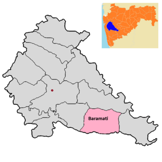
Baramati taluka is a taluka in Baramati subdivision of Pune district of state of Maharashtra in India.
Gurholi is a village in Purandar Taluka, India, with an economy based mainly on agriculture where fruits such as figs, custard apples, and pomegranates are produced. The village is surrounded by three mountains, and has temples among the mountains.

Loni Kalbhor is a village 11 kilometres east of the City of Pune, Maharashtra, India.
Hasur is a village in Maharashtra, India. It is located in the Krishna river basin, in the Desh region. The village is a part of the Shirol taluka of Kolhapur district, Pune Division.
Mau is a village in India, situated in Mawal taluka of Pune district in the state of Maharashtra. It encompasses an area of 832.11 ha.
Vehergaon is a village in Mawal taluka of Pune district in the state of Maharashtra, India. It encompasses an area of 397 ha.
Wahangaon is a village in Mawal taluka of Pune district in the state of Maharashtra, India. It encompasses an area of 629 ha.
Mugaon is a village in Mulshi taluka of Pune District in the state of Maharashtra, India.Talukas surrounding the village are Karjat taluka, Talegaon Dabhade Taluka, Mawal taluka and by Khalapur taluka. Districts closest to the village are Raigad district, Thane district, Mumbai City district and Mumbai Suburban district. Nearest railway stations around the village are Vadgaon railway station, Begdewadi railway station, Lonavala railway station, Talegaon railway station and Kamshet railway station.
Bharadi is a village in Ambegaon taluka of Pune District in the state of Maharashtra, India. The village is administrated by a Sarpanch who is an elected representative of village as per constitution of India and Panchayati raj (India).
Mangdari is a village in Velhe Taluka in the Pune District of Maharashtra, India.


