La Casita-Garciasville, Texas | |
---|---|
former CDP | |
Coordinates: 26°19′34″N98°42′25″W / 26.32611°N 98.70694°W | |
Country | United States |
State | Texas |
County | Starr |
Area | |
• Total | 4.4 sq mi (11.3 km2) |
• Land | 4.3 sq mi (11.3 km2) |
• Water | 0.0 sq mi (0.1 km2) |
Population (2000) | |
• Total | 2,177 |
• Density | 501.0/sq mi (193.5/km2) |
Time zone | UTC-6 (Central (CST)) |
• Summer (DST) | UTC-5 (CDT) |
FIPS code | 48-40005 [1] |
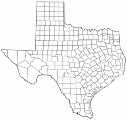
La Casita-Garciasville is a former census-designated place (CDP) in Starr County, Texas, United States. The population was 2,177 at the 2000 census.
La Casita-Garciasville is located at 26°19′34″N98°42′25″W / 26.32611°N 98.70694°W (26.326127, -98.707054). [2]
According to the United States Census Bureau, the CDP has a total area of 4.4 square miles (11.3 km2), of which 4.3 square miles (11.2 km2) is land and 0.04 square mile (0.1 km2) (0.68%) is water.
Census | Pop. | Note | %± |
---|---|---|---|
1990 | 1,186 | — | |
2000 | 2,177 | 83.6% | |
U.S. Decennial Census [3] 1850–1900 [4] 1910 [5] 1920 [6] 1930 [7] 1940 [8] 1950 [9] 1960 [10] 1970 [11] 1980 [12] 1990 [13] 2000 [14] 2010 [15] |
La Casita-Garciasville first appeared as a census designated place in the 1990 U.S. Census. [13] Prior to the 2010 census, the CDP was deleted and parts were taken to form Amada Acres, Chaparrito, La Casita, Loma Linda East, Manuel Garcia, Manuel Garcia II, Olivia Lopez de Gutierrez, Ramirez-Perez and Victoria Vera CDPs. [15]
Race / Ethnicity (NH = Non-Hispanic) | Pop 2000 [16] | % 2000 |
---|---|---|
White alone (NH) | 15 | 0.69% |
Black or African American alone (NH) | 0 | 0.00% |
Native American or Alaska Native alone (NH) | 0 | 0.00% |
Asian alone (NH) | 0 | 0.00% |
Pacific Islander alone (NH) | 0 | 0.00% |
Other race alone (NH) | 1 | 0.05% |
Mixed race or Multiracial (NH) | 3 | 0.14% |
Hispanic or Latino (any race) | 2,158 | 99.13% |
Total | 2,177 | 100.00% |
As of the census [1] of 2000, there were 2,177 people, 562 households, and 501 families residing in the CDP. The population density was 501.0 inhabitants per square mile (193.4/km2). There were 668 housing units at an average density of 153.7 per square mile (59.3/km2). The racial makeup of the CDP was 87.74% White, 0.05% Native American, 10.52% from other races, and 1.70% from two or more races. Hispanic or Latino of any race were 99.13% of the population.
There were 562 households, out of which 56.0% had children under the age of 18 living with them, 69.0% were married couples living together, 15.8% had a female householder with no husband present, and 10.7% were non-families. 10.5% of all households were made up of individuals, and 4.8% had someone living alone who was 65 years of age or older. The average household size was 3.87 and the average family size was 4.19.
In the CDP, the population was spread out, with 39.0% under the age of 18, 11.1% from 18 to 24, 27.4% from 25 to 44, 15.0% from 45 to 64, and 7.5% who were 65 years of age or older. The median age was 25 years. For every 100 females, there were 104.4 males. For every 100 females age 18 and over, there were 94.7 males.
The median income for a household in the CDP was $15,921, and the median income for a family was $17,149. Males had a median income of $14,948 versus $11,442 for females. The per capita income for the CDP was $5,507. About 44.9% of families and 53.0% of the population were below the poverty line, including 64.2% of those under age 18 and 32.7% of those age 65 or over.
Garciasville is served by the Rio Grande City Consolidated Independent School District.
Encantada-Ranchito-El Calaboz, also known as El Calaboz Rancheria in the San Pedro de Carricitos Land Grant, is a census-designated place (CDP) in Cameron County, Texas, United States. The population was 1,981 at the 2020 census. It is part of the Brownsville–Harlingen Metropolitan Statistical Area.
La Feria North is a census-designated place (CDP) in Cameron County, Texas, United States. The population was 225 at the 2020 census. It is part of the Brownsville–Harlingen Metropolitan Statistical Area.
Laureles is a census-designated place (CDP) in Cameron County, Texas, United States. The population was 4,111 at the 2020 census. It is part of the Brownsville–Harlingen Metropolitan Statistical Area. Laureles is an area between Los Fresnos and San Benito.
Olmito is a census-designated place (CDP) in Cameron County, Texas, United States. Olmito is Spanish for "little elm". The population was 1,021 at the 2020 census. It is part of the Brownsville–Harlingen Metropolitan Statistical Area. Olmito is the self-described "mesquite capital of the world."
Concepcion is an unincorporated community and census-designated place (CDP) in Duval County, Texas, United States. The population was 42 at the 2020 census.
Gardendale is an unincorporated area and census-designated place (CDP) in Ector County, Texas, United States. The population was 2,020 at the 2020 census, up from 1,574 at the 2010 census. It is part of the Odessa, Texas, Metropolitan Statistical Area.
Bigfoot is an unincorporated community and census-designated place (CDP) in Frio County, Texas, United States. The population was 450 at the 2010 census, up from 304 at the 2000 census.
McQueeney is an unincorporated community and census-designated place (CDP) in Guadalupe County, Texas, United States. The population was 2,397 at the 2020 census. It is part of the San Antonio Metropolitan Statistical Area.
Zuehl is an unincorporated area and census-designated place in western Guadalupe County, Texas, United States. It is part of the San Antonio Metropolitan Statistical Area. Located on Cibolo Creek, it lies 13 miles (21 km) southwest of Seguin. The population was 399 at the 2020 census.
Abram-Perezville is a former census-designated place (CDP) in Hidalgo County, Texas. The population was 5,376 at the 2010 United States Census. It is part of the McAllen–Edinburg–Mission Metropolitan Statistical Area. For the 2010 census, the CDP was split into Abram and Perezville.
Cuevitas is a census-designated place (CDP) in Hidalgo County, Texas, United States. The population was 40 at the 2010 United States Census. Rated the poorest community in Texas, it is part of the McAllen–Edinburg–Mission Metropolitan Statistical Area.
Doffing is a census-designated place (CDP) in Hidalgo County, Texas, United States. The population was 5,091 at the 2010 United States Census. It is part of the McAllen–Edinburg–Mission Metropolitan Statistical Area.
Midway North is a census-designated place (CDP) in Hidalgo County, Texas, United States. The population was 4,232 at the 2020 United States Census. It is part of the McAllen–Edinburg–Mission Metropolitan Statistical Area.
San Carlos is a community and census-designated place (CDP) in Hidalgo County, Texas. The population was 3,087 at the 2020 United States Census. It is part of the McAllen–Edinburg–Mission Metropolitan Statistical Area.
Coyote Acres is a census-designated place (CDP) in Jim Wells County, Texas, United States. The population was 570 at the 2020 census, up from 508 at the 2010 census.
Loma Linda East is a census-designated place (CDP) in Jim Wells County, Texas, United States. The population was 305 at the 2020 census, up from 254 at the 2010 census.
El Refugio is a census-designated place (CDP) in Starr County, Texas, United States. The population was 407 at the 2020 census. El Refugio gained area in the 2010 census.
Bruni is a census-designated place (CDP) in Webb County, Texas, United States. The population was 379 at the 2010 census.
Laredo Ranchettes is a census-designated place (CDP) in Webb County, Texas, United States. The population was 22 at the 2010 census.
Ranchitos Las Lomas is a census-designated place (CDP) in Webb County, Texas, United States. The population was 167 at the 2020 census. Las Lomas means "the hills" in Spanish.