Garceno, Texas

Last updated

Garceno, Texas
CDP
TXMap-doton-Garceno.PNG
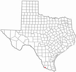
Location of Garceno, Texas
Starr County Garceno.svg
Coordinates: 26°24′44″N98°56′25.5″W / 26.41222°N 98.940417°W / 26.41222; -98.940417
Country United States
State Texas
County Starr
Area
  Total0.2 sq mi (0.5 km2)
  Land0.2 sq mi (0.5 km2)
  Water0.0 sq mi (0 km2)
Elevation
194 ft (59 m)
Population
 (2010)
  Total420
  Density2,100/sq mi (810/km2)
Time zone UTC-6 (Central (CST))
  Summer (DST) UTC-5 (CDT)
ZIP code
78584
Area code 956
FIPS code 48-28128 [1]
GNIS feature ID1336371 [2]

Garceno is a census-designated place (CDP) in Starr County, Texas, United States. The population was 420 at the 2010 census, a decline from the figure of 1,438 tabulated in 2000. [3]

Contents

Geography

Garceno is located at 26°24′44″N98°56′25.5″W / 26.41222°N 98.940417°W / 26.41222; -98.940417 (26.412177, -98.940428).

Prior to the 2010 census, Garceno CDP had part incorporated into Escobares city, part taken to form San Juan CDP, and lost additional area. As a result, the total area was reduced to 0.2 square miles (0.5 km2), all land. [4] > [5]

Demographics

At the 2000 census there were 1,438 people, 354 households, and 312 families in the CDP. The population density was 440.6 inhabitants per square mile (170.1/km2). There were 420 housing units at an average density of 128.7 per square mile (49.7/km2). The racial makeup of the CDP was 82.41% White, 0.21% African American, 1.46% Native American, 14.81% from other races, and 1.11% from two or more races. Hispanic or Latino of any race were 97.71%. [1]

Of the 354 households 57.9% had children under the age of 18 living with them, 63.6% were married couples living together, 18.6% had a female householder with no husband present, and 11.6% were non-families. 10.5% of households were one person and 4.8% were one person aged 65 or older. The average household size was 4.06 and the average family size was 4.35.

The age distribution was 39.2% under the age of 18, 12.6% from 18 to 24, 25.9% from 25 to 44, 16.1% from 45 to 64, and 6.2% 65 or older. The median age was 24 years. For every 100 females, there were 99.4 males. For every 100 females age 18 and over, there were 92.1 males.

The median household income was $9,750 and the median family income was $10,833. Males had a median income of $12,670 versus $7,132 for females. The per capita income for the CDP was $5,922. About 68.8% of families and 71.1% of the population were below the poverty line, including 76.1% of those under age 18 and 77.3% of those age 65 or over.
Education

Public education in the community of Garceno is provided by the Roma Independent School District. [6] The zoned elementary school is R. T. Barrera Elementary School. [7] Roma High School is the district's sole comprehensive high school.

Zoned campuses for the 2009-2010 school year included Anna S. Canavan Elementary School (pre-kindergarten), R.T. Barrera Elementary School (grades K-5), Ramiro Barrera Middle School Archived 2010-07-31 at the Wayback Machine (grades 6-8), and Roma High School Archived 2009-09-20 at the Wayback Machine (grades 9-12). [8] [9]

Related Research Articles

<span class="mw-page-title-main">Richwood, Texas</span> City in Texas, United States

Richwood is a city in Brazoria County, Texas, United States. The population was 4,781 at the 2020 census.

<span class="mw-page-title-main">Prado Verde, Texas</span> Census-designated place in Texas, United States

Prado Verde is a census-designated place (CDP) in El Paso County, Texas, United States. The population is 246 according to the 2010 census. It is part of the El Paso Metropolitan Statistical Area. The ZIP Code encompassing the CDP area is 79932.

<span class="mw-page-title-main">Channelview, Texas</span> Census-designated place in Texas, United States

Channelview is a census-designated place (CDP) in the U.S. state of Texas on the east side of Houston in Harris County. Its population was 45,688 at the 2020 U.S. census.

<span class="mw-page-title-main">Escobares, Texas</span> City in Texas, United States

Escobares is a city in Starr County, Texas, United States. The population was 2,588 at the 2020 census. The city was formed in 2005 from part of the deleted Escobares CDP, and parts of Garceno, and North Escobares CDPs, and additional area. Prior to its 2005 incorporation as a city, it was a census-designated place (CDP). The population of the CDP was 1,954 at the 2000 census.

<span class="mw-page-title-main">Falcon Heights, Texas</span> CDP in Texas, United States

Falcon Heights is a census-designated place (CDP) in Starr County, Texas, United States. The population was 18 at the 2020 census, down from 53 at the 2010 census.

<span class="mw-page-title-main">Falcon Village, Texas</span> CDP in Texas, United States

Falcon Village is a census-designated place (CDP) in Starr County, Texas, United States. The population was 3 at the 2020 census.

<span class="mw-page-title-main">Fronton, Texas</span> CDP in Texas, United States

Fronton is a census-designated place (CDP) in Starr County, Texas, United States, bordering the Mexican state of Tamaulipas, close to Ciudad Miguel Alemán. The population was 180 at the 2010 census, a decline from the figure of 599 tabulated in 2000.

<span class="mw-page-title-main">La Rosita, Texas</span> CDP in Texas, United States

La Rosita is a census-designated place (CDP) in Starr County, Texas, United States. The population was 85 at the 2010 census, a decline from the figure of 1,729 tabulated in 2000d due to the Census Bureau redefining the CDP.

<span class="mw-page-title-main">Los Alvarez, Texas</span> CDP in Texas, United States

Los Alvarez is a census-designated place (CDP) in Starr County, Texas, United States. The population was 303 at the 2010 census, a decline from the figure of 1,434 tabulated in 2000.

<span class="mw-page-title-main">Los Villareales, Texas</span> Former CDP in Texas, United States

Los Villareales is a former census-designated place (CDP) in Starr County, Texas, United States. The population was 930 at the 2000 census. The CDP was deleted prior to the 2010 census. Part was annexed to Rio Grande City and parts were taken to form all of La Escondida, La Esperanza, and Santel CDPs and parts of Mi Ranchito Estate and Ranchitos del Norte CDPs.

<span class="mw-page-title-main">North Escobares, Texas</span> CDP in Texas, United States

North Escobares is a census-designated place (CDP) in Starr County, Texas, United States. The population was 118 at the 2010 census, a decline from the figure of 1,692 tablulated in 2000.

<span class="mw-page-title-main">Roma Creek, Texas</span> CDP in Texas, United States

Roma Creek is a former census-designated place (CDP) in Starr County, Texas, United States. The population was 350 at the 2010 census down from 610 at the 2000 census.

<span class="mw-page-title-main">Salineño, Texas</span> CDP in Texas, United States

Salineño is a census-designated place (CDP) in Starr County, Texas, United States. The name was changed in 2008, adding a tilde over the second n. The population was 176 at the 2020 census, down from 201 at the 2010 census.

<span class="mw-page-title-main">Mirando City, Texas</span> CDP in Texas, United States

Mirando City is a census-designated place (CDP) in Webb County, Texas, United States. It is approximately 30 miles east of Laredo and 130 miles southwest of Corpus Christi. The population was 166 at the 2010 census. The town gets its name from Nicolás Mirando, a Spanish land grantee. The population of Mirando City was highest in 1929, at an estimated 1500.

<span class="mw-page-title-main">Mission Bend, Texas</span> Census-designated place in Texas, United States

Mission Bend is a census-designated place (CDP) around Texas State Highway 6 within the extraterritorial jurisdiction of Houston in Fort Bend and Harris counties in the U.S. state of Texas; Mission Bend is 4 miles (6 km) northwest of the city hall of Sugar Land and 20 miles (32 km) southwest of Downtown Houston. The population was 36,914 at the 2020 census.

Los Barreras is a census-designated place (CDP) in Starr County, Texas, United States. It is a new CDP, formed from part of the La Rosita CDP prior to the 2010 census, with a population of 288.

Miguel Barrera is a census-designated place (CDP) in Starr County, Texas, United States. It is a new CDP, formed from part of the La Rosita CDP prior to the 2010 census, with a population of 128.

Barrera is a census-designated place (CDP) in Starr County, Texas, United States. It is a new CDP formed from part of the Los Alvarez CDP prior to the 2010 census with a population of 108.

Mesquite is a census-designated place (CDP) in Starr County, Texas, United States. It is a new CDP, formed from part of the former Escobares CDP prior to the 2010 census, with a population of 505.

San Juan is a census-designated place (CDP) in Starr County, Texas, United States. It is a new CDP formed from part of the Garceno CDP prior to the 2010 census, with a population of 129.

References

  1. 1 2 "U.S. Census website". United States Census Bureau . Retrieved January 31, 2008.
  2. "US Board on Geographic Names". United States Geological Survey. October 25, 2007. Retrieved January 31, 2008.
  3. "2010 Census: Population of Texas Cities Arranged in Alphabetical Order - TSLAC".
  4. "Population and Housing Unit Counts, 2010 Census of Population and Housing" (PDF). Texas: 2010.
  5. "Garceno, Texas :: Boundary Map of Garceno, Texas".
  6. "2020 CENSUS - SCHOOL DISTRICT REFERENCE MAP: Starr County, TX" (PDF). U.S. Census Bureau . Retrieved August 28, 2022. - 2010 map
  7. "Roma ISD School Boundaries". Roma Independent School District . Retrieved August 29, 2022.
  8. "2009-2010 Roma ISD Elementary Boundaries" (PDF). Roma Independent School District. Archived from the original (PDF) on July 15, 2011. Retrieved October 13, 2009.
  9. "2009-2010 Roma ISD Middle School Boundaries" (PDF). Roma Independent School District. Archived from the original (PDF) on July 15, 2011. Retrieved October 13, 2009.