La Casita-Garciasville, Texas

Last updated
La Casita-Garciasville, Texas
former CDP
TXMap-doton-ElRefugio.PNG
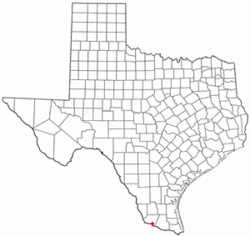
Location of La Casita-Garciasville, Texas
Starr County LaCasitaGarciasville.svg
Coordinates: 26°19′34″N98°42′25″W / 26.32611°N 98.70694°W / 26.32611; -98.70694
Country United States
State Texas
County Starr
Area
  Total4.4 sq mi (11.3 km2)
  Land4.3 sq mi (11.3 km2)
  Water0.0 sq mi (0.1 km2)
Population
 (2000)
  Total2,177
  Density501.0/sq mi (193.5/km2)
Time zone UTC-6 (Central (CST))
  Summer (DST) UTC-5 (CDT)
FIPS code 48-40005 [1]

La Casita-Garciasville is a former census-designated place (CDP) in Starr County, Texas, United States. The population was 2,177 at the 2000 census.

Contents

Prior to the 2010 census, the CDP was deleted and parts were taken to form Amada Acres, Chaparrito, La Casita, Loma Linda East, Manuel Garcia, Manuel Garcia II, Olivia Lopez de Gutierrez, Ramirez-Perez and Victoria Vera CDPs. [2]

Geography

La Casita-Garciasville is located at 26°19′34″N98°42′25″W / 26.32611°N 98.70694°W / 26.32611; -98.70694 (26.326127, -98.707054). [3]

According to the United States Census Bureau, the CDP has a total area of 4.4 square miles (11.3 km2), of which 4.3 square miles (11.2 km2) is land and 0.04 square mile (0.1 km2) (0.68%) is water.

Demographics

As of the census [1] of 2000, there were 2,177 people, 562 households, and 501 families residing in the CDP. The population density was 501.0 inhabitants per square mile (193.4/km2). There were 668 housing units at an average density of 153.7 per square mile (59.3/km2). The racial makeup of the CDP was 87.74% White, 0.05% Native American, 10.52% from other races, and 1.70% from two or more races. Hispanic or Latino of any race were 99.13% of the population.

There were 562 households, out of which 56.0% had children under the age of 18 living with them, 69.0% were married couples living together, 15.8% had a female householder with no husband present, and 10.7% were non-families. 10.5% of all households were made up of individuals, and 4.8% had someone living alone who was 65 years of age or older. The average household size was 3.87 and the average family size was 4.19.

In the CDP, the population was spread out, with 39.0% under the age of 18, 11.1% from 18 to 24, 27.4% from 25 to 44, 15.0% from 45 to 64, and 7.5% who were 65 years of age or older. The median age was 25 years. For every 100 females, there were 104.4 males. For every 100 females age 18 and over, there were 94.7 males.

The median income for a household in the CDP was $15,921, and the median income for a family was $17,149. Males had a median income of $14,948 versus $11,442 for females. The per capita income for the CDP was $5,507. About 44.9% of families and 53.0% of the population were below the poverty line, including 64.2% of those under age 18 and 32.7% of those age 65 or over.

Education

Garciasville is served by the Rio Grande City Consolidated Independent School District.

Related Research Articles

<span class="mw-page-title-main">Wofford Heights, California</span> Census-designated place in California, United States

Wofford Heights is a census-designated place (CDP) in the southern Sierra Nevada, in Kern County, California, United States. Wofford Heights is located in the west Kern River Valley, 3.5 miles (5.6 km) south-southwest of Kernville, at an elevation of 2,684 feet (818 m). The population was 2,200 at the 2010 census, down from 2,276 at the 2000 census.

<span class="mw-page-title-main">Cromberg, California</span> Census-designated place in California, United States

Cromberg is a census-designated place (CDP) in Plumas County, California, United States. Cromberg is located on the Western Pacific Railroad, 6.5 miles (10.5 km) northwest of Blairsden. The population was 261 at the 2010 census, down from 290 at the 2000 census.

<span class="mw-page-title-main">Glasgow, Delaware</span> CDP in Delaware, United States

Glasgow is a census-designated place (CDP) in New Castle County, Delaware, United States. The population was 14,303 at the 2010 census.

<span class="mw-page-title-main">South Beach, Florida</span> Census-designated place in Florida, United States

South Beach is a census-designated place (CDP) on North Hutchinson Island in Indian River County, Florida, United States. The population was 3,501 at the 2010 census. It is ranked tenth in Florida locations by per capita income as of 2010.

<span class="mw-page-title-main">Lakewood Park, Florida</span> Census-designated place in Florida, United States

Lakewood Park is a Census-designated place in St. Lucie County, Florida, United States. The population was 11,323 at the 2010 census. It is part of the Port St. Lucie Metropolitan Statistical Area.

<span class="mw-page-title-main">Kalaheo, Hawaii</span> Census-designated place in Hawaii, United States

Kalāheo is an unincorporated community and census-designated place (CDP) in Kauaʻi County, island of Kauaʻi, Hawaiʻi, United States. The population was 4,996 at the 2020 census, up from 3,913 at the 2000 census.

<span class="mw-page-title-main">Simonton Lake, Indiana</span> Census-designated place in Indiana, United States

Simonton Lake is a census-designated place (CDP) in Elkhart County, Indiana, United States. The population was 4,678 at the 2010 census.

<span class="mw-page-title-main">Mount Lena, Maryland</span> CDP in Maryland, United States

Mount Lena is a census-designated place (CDP) in Washington County, Maryland, United States. The population was 501 at the 2000 census.

<span class="mw-page-title-main">Dayton, Montana</span> Census-designated place in Montana, United States

Dayton is an unincorporated community and census-designated place (CDP) in Lake County, Montana, United States. The population was 84 at the 2010 census.

<span class="mw-page-title-main">Newcomb, New Mexico</span> CDP in New Mexico, United States

Newcomb is a census-designated place (CDP) in San Juan County, New Mexico, United States. The population was 387 at the 2000 census. It is part of the Farmington Metropolitan Statistical Area.

East Rockingham is a census-designated place (CDP) in Richmond County, North Carolina, United States. The population was 3,885 at the 2000 census.

<span class="mw-page-title-main">Crystal Lakes, Ohio</span> Census-designated place in Ohio, United States

Crystal Lakes is a census-designated place (CDP) in Clark County, Ohio, United States. The population was 1,394 at the 2020 census. It is part of the Springfield, Ohio Metropolitan Statistical Area.

<span class="mw-page-title-main">Holiday Valley, Ohio</span> Census-designated place in Ohio, United States

Holiday Valley is a census-designated place (CDP) in Clark County, Ohio, United States. The population was 1,480 at the 2020 census. It is part of the Springfield, Ohio Metropolitan Statistical Area.

<span class="mw-page-title-main">Choctaw Lake, Ohio</span> CDP in Ohio, United States

Choctaw Lake is a census-designated place (CDP) in Madison County, Ohio, United States. The population was 1,562 at the 2000 census.

<span class="mw-page-title-main">West Hills, Pennsylvania</span> Census-designated place in Pennsylvania, United States

West Hills is a census-designated place (CDP) in Armstrong County, Pennsylvania, United States. The population was 1,263 at the 2010 census.

Black Lick is a census-designated place (CDP) in Burrell Township, Indiana County, Pennsylvania, United States. The population was 1,462 at the 2010 census.

<span class="mw-page-title-main">Lea Hill, Auburn, Washington</span> Neighborhood in King, Washington, United States

Lea Hill is a neighborhood located in the city of Auburn, Washington, United States. The community was annexed by Auburn on January 1, 2008, after Auburn and Lea Hill residents approved the annexation.

<span class="mw-page-title-main">Kennebunk (CDP), Maine</span> Census-designated place in Maine, United States

Kennebunk is a census-designated place (CDP) comprising the central village in the town of Kennebunk in York County, Maine, United States. The population was 5,214 at the 2010 census, out of a total town population of 10,798. It is part of the Portland–South Portland–Biddeford, Maine Metropolitan Statistical Area.

<span class="mw-page-title-main">Kittery (CDP), Maine</span> Census-designated place in Maine, United States

Kittery is a census-designated place (CDP) consisting of the main village in the town of Kittery in York County, Maine, United States. The village is also known as Kittery Foreside. The population of the CDP was 4,562 at the 2010 census. It is part of the Portland–South Portland–Biddeford, Maine Metropolitan Statistical Area.

Newport is a census-designated place (CDP) consisting of the main area of settlement within the town of Newport in Penobscot County, Maine, United States. The population of the CDP was 1,776 at the 2010 census.

References

  1. 1 2 "U.S. Census website". United States Census Bureau . Retrieved 2008-01-31.
  2. https://www.census.gov/prod/cen2010/cph-2-45.pdf [ bare URL PDF ]
  3. "US Gazetteer files: 2010, 2000, and 1990". United States Census Bureau. 2011-02-12. Retrieved 2011-04-23.