
The Republic of Haiti comprises the western three-eighths of the island of Hispaniola, west of the Dominican Republic. Haiti is positioned east of the neighboring island of Cuba, between the Caribbean Sea and the North Atlantic Ocean. Haiti's geographic coordinates are at a longitude of 72° 25′ west and a latitude of 19° 00′ north.

Lake Geneva is a deep lake on the north side of the Alps, shared between Switzerland and France. It is one of the largest lakes in Western Europe and the largest on the course of the Rhône. Sixty per cent of the lake belongs to Switzerland and forty per cent to France.
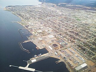
Sept-Îles is a city in the Côte-Nord region of eastern Quebec. It is among the northernmost locales with a paved connection to the rest of Quebec's road network. The population was 25,686 as of the 2011 Canadian census. The town is called Uashat, meaning "bay" in Innu-aimun.

Épinay-sur-Orge is a commune in the Essonne department in Île-de-France in northern France.
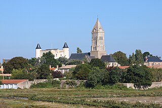
Noirmoutier-en-l'Île, commonly referred to as Noirmoutier, is a commune located in the northern part of the island of Noirmoutier, just off the coast of the Vendée department in the Pays de la Loire region in western France.
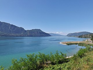
Lac du Bourget, also locally known as Lac Gris or Lac d'Aix, is a lake at the southernmost end of the Jura Mountains in the department of Savoie, France. It is the deepest lake located entirely within France, and either the largest or second largest after Lac de Grand-Lieu depending on season.

Divonne-les-Bains, popularly known as Divonne, is a commune in the Ain department in the Auvergne-Rhône-Alpes region in Eastern France. In 2018, it had a population of 9,788.
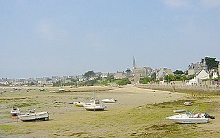
The Île de Batz is an island off Roscoff in Brittany, France. Administratively, it is a commune in the Finistère department of Brittany in north-western France.

The arrondissement of Chambéry is an arrondissement of France in the Savoie department in the Auvergne-Rhône-Alpes region. It has 151 communes. Its population is 274,839 (2016), and its area is 1,586.1 km2 (612.4 sq mi).

The Île de Sein[il də sɛ̃] is a Breton island in the Atlantic Ocean, off Finistère, eight kilometres from the Pointe du Raz, from which it is separated by the Raz de Sein. Its Breton name is Enez-Sun. The island, with its neighbouring islets, forms the commune of Île-de-Sein in the Finistère department of Brittany in north-western France. Inhabitants of Île-de-Sein are called in French Sénans.

Petite-Île is a commune on the French island and department of Réunion. The commune is bordered by the communes of Saint-Joseph to the east and Saint-Pierre to the west. The commune gets its name from the uninhabited islet off of its coast, the only such islet near Réunion that has vegetation. The commune was established in 1935.

Aiguebelette-le-Lac is a commune and village in the Savoie department in the Auvergne-Rhône-Alpes region in south-eastern France. In 2016, it had a population of 249 people. It is named after and lies near the southeastern shore of Lac d'Aiguebelette, one of the largest natural lakes of France. Le Port is a small port on the lake, with a beach. The commune contains the Château d'Aiguebelette, a medieval structure which is in a ruinous state, while the main church in the area, dedicated to Saint Andrew, was restored in 1854.

Saint-Alban-d'Hurtières is a commune in the Savoie department in the Auvergne-Rhône-Alpes region in south-eastern France.

The Chaîne de l'Épine, in the department of Savoie in southeast France, is a 20-kilometre (12 mi) long ridge of the Jura Mountains that runs north–south along the east side of the Lac d'Aiguebelette, from the Col de l'Épine west of Chambéry as far as the western edge of the Chartreuse Mountains, near the commune of Les Échelles. To the north, the ridge becomes the Mont du Chat ridge along the western shore of the Lac du Bourget. At the southern end, the ridge terminates at the Guiers River.
The canton of Le Pont-de-Beauvoisin is an administrative division of the Savoie department, southeastern France. Its borders were modified at the French canton reorganisation which came into effect in March 2015. Its seat is in Le Pont-de-Beauvoisin.

The MacDonald River is a river in Quebec, Canada, to the north of the lower Saint Lawrence River. It is known for its dramatic cascade, the Chute MacDonald.
The Schmon River is a river in the Côte-Nord region of the province of Quebec, Canada. It flows south into Lake Walker.
Lake Quatre Lieues is a lake in the province of Quebec, Canada. It is set in a wilderness area and may be used for relaxation, fishing or hunting.
Lake Nipisso is a 40 square kilometres (15 sq mi) lake in a remote part of the Côte-Nord region of Quebec, Canada.

The Épine Tunnel is a motorway tunnel situated in France, in the Savoie department, in the Auvergne-Rhône-Alpes region.


