Lakandon Ch'ol

Last updated
Map showing the territory inhabited by the Lakandon Ch'ols in the 17th century Contact Period lowland Guatemala.gif
Map showing the territory inhabited by the Lakandon Ch'ols in the 17th century

The Lakandon Ch'ol were a former Ch’ol-speaking Maya people inhabiting the Lacandon Jungle in what is now lowland Chiapas in Mexico and the bordering regions of northwestern Guatemala, [1] along the tributaries of the upper Usumacinta River and the foothills of the Sierra de los Cuchumatanes. [2]

Maya peoples People of southern Mexico and northern Central America

The Maya peoples are a large group of indigenous peoples of Mesoamerica. They inhabit southern Mexico, Guatemala, Belize, El Salvador and Honduras. The overarching term "Maya" is a collective designation to include the peoples of the region that share some degree of cultural and linguistic heritage; however, the term embraces many distinct populations, societies and ethnic groups that each have their own particular traditions, cultures and historical identity.

Lacandon Jungle area of rainforest

The Lacandon Jungle is an area of rainforest which stretches from Chiapas, Mexico, into Honduras and into the southern part of the Yucatán Peninsula. The heart of this rainforest is located in the Montes Azules Biosphere Reserve in Chiapas near the border with Guatemala in the Montañas del Oriente region of the state. Although most of the jungle outside the reserve has been partially or completely destroyed and damage continues inside the Reserve, the Lacandon is still the largest montane rainforest in North America and one of the last ones left large enough to support jaguars. It contains 1,500 tree species, 33% of all Mexican bird species, 25% of all Mexican animal species, 56% of all Mexican diurnal butterflies and 16% of all Mexico's fish species.

Contents

The Lakandon Ch'ol at contact with the Spanish

The Lakandon Ch'ol of the time of the Spanish conquest should not be confused with the modern Yucatec-speaking Lacandon people occupying the same region. [3] At the time of Spanish contact in the 16th century, the Lacandon Jungle was inhabited by Ch'ol people referred to as Lakam Tun. This name was hispanicised, first to El Acantun, then to Lacantun and finally to Lacandon. [4] The main Lakandon village was situated on an island in Lake Miramar, also referred to as Lakam Tun by the inhabitants. [5] The Lakandons, together with their equally unconquered Itza enemies to the northeast, had an especially warlike reputation among the Spanish. [6]

The Spanish conquest of Chiapas was the campaign undertaken by the Spanish conquistadores against the Late Postclassic Mesoamerican polities in the territory that is now incorporated into the modern Mexican state of Chiapas. The region is physically diverse, featuring a number of highland areas, including the Sierra Madre de Chiapas and the Montañas Centrales, a southern littoral plain known as Soconusco and a central depression formed by the drainage of the Grijalva River.

Yucatec Maya, called mayaʼ tʼàan by its speakers, is a Mayan language spoken in the Yucatán Peninsula and northern Belize. To native speakers, the proper name is Maya and it is known only as Maya. The qualifier "Yucatec" is a tag linguists use to distinguish it from other Mayan languages. Thus the use of the term Yucatec Maya to refer to the language is scientific jargon or nomenclature.

Later history

Hernán Cortés first heard of the existence of the Lakandon when he was passing through Kejache territory in 1524, although he did not actually contact them. [7] During the 16th century, the Spanish colonial authorities in Verapaz, within the Captaincy General of Guatemala, complained that baptised Maya were fleeing colonial towns in order to find refuge among the independent Lakandon and their Manche Ch'ol neighbours. [8] The first Spanish expedition against the Lakandons was carried out in 1559, commanded by Pedro Ramírez de Quiñones. [9]

Hernán Cortés Spanish conquistador

Hernán Cortés de Monroy y Pizarro Altamirano, Marquis of the Valley of Oaxaca was a Spanish Conquistador who led an expedition that caused the fall of the Aztec Empire and brought large portions of what is now mainland Mexico under the rule of the King of Castile in the early 16th century. Cortés was part of the generation of Spanish colonizers who began the first phase of the Spanish colonization of the Americas.

Kejache

The Kejache were a Maya people in the southern Yucatán Peninsula at the time of Spanish contact in the 17th century. The Kejache territory was located in the Petén Basin in a region that takes in parts of both Guatemala and Mexico. Linguistic evidence indicates that the Kejache shared a common origin with the neighbouring Itzas to their southeast and the Kejache may have occupied the general region since the Classic period. The Kejache were initially contacted by conquistador Hernán Cortés in 1525; they were later in prolonged contact with the Spanish as the latter opened a route southwards towards Lake Petén Itzá.

Verapaz or Vera Paz was a historical region in the Spanish colonial Captaincy General of Guatemala.

At the end of the 16th century, under pressure from the advancing Spanish frontier, the Lakandon Ch'ol abandoned Lakam Tun and withdrew deeper into the forest to the southeast where they founded a new town, Sakb'ajlan, within a wide curve of the Lacantún River. [10] The name of the town translated as "white jaguar". The Lakandons had two other settlements further east, called Map and Peta. [11]

The Lacantún River is a river of Mexico.

During the course of the 17th century, the Lakandon Ch'ol raided the Guatemalan Highlands to such an extent that it was considered unsafe to travel in the region surrounding San Mateo Ixtatán and Santa Eulalia in the Sierra de los Cuchumatanes, [12] within the colonial Corregimiento de Totonicapán y Huehuetenango administrative division. [13] In response, the colonial authorities placed garrisons in both towns in order to protect the local inhabitants against Lakandon raids, with limited success. [12] The Lakandon Ch'ol traded with the colonial Maya towns of Cobán and Cahabón in Alta Verapaz, receiving quetzal feathers, copal, chile, cotton, salt and Spanish-produced iron tools in exchange for cacao and achiote. [14] From time to time the Spanish launched punitive military expeditions against the Lakandons to try to stabilise the northern frontier of the Guatemalan colony; the largest expeditions took place in 1685 and 1695. [15]

San Mateo Ixtatán Municipality in Huehuetenango, Guatemala

San Mateo Ixtatán is a municipality in the Guatemalan department of Huehuetenango. It is situated at 2,540 metres (8,330 ft) above sea level in the Cuchumatanes mountain range and covers 560 square kilometres (220 sq mi) of terrain. It has a cold climate and is located in a cloud forest. The temperature fluctuates between 0.5 and 20 °C. The coldest months are from November to January and the warmest months are April and May. The town has a population of about 10,000, and is the municipal center for an additional 20,000 people living in the surrounding mountain villages. It has a weekly market on Thursday and Sunday. The annual town festival takes place from September 19 to September 21 honoring their patron Saint Matthew. The residents of San Mateo belong to the Chuj Maya ethnic group and speak the Mayan Chuj language, not to be confused with Chuj baths, or wood fired steam rooms that are common throughout the central and western highlands.

Santa Eulalia also known as Jolom Konob' is a municipality located in the north-east of the department of Huehuetenango, Guatemala, Central America. This town is rich in culture and traditions. The majority of people here speak the Q'anjob'al language.

Cobán Place in Alta Verapaz, Guatemala

Cobán, fully Santo Domingo de Cobán, is the capital of the department of Alta Verapaz in central Guatemala. It also serves as the administrative center for the surrounding Cobán municipality. It is located 219 km from Guatemala City.

Conversion and resettlement

Franciscan friars Antonio Margil and Melchor López were active among the Lakandon and Manche Ch'ol between 1692 and 1694; they eventually outstayed their welcome and were expelled by the Ch'ol. [16] Most of the Lakandon Ch'ol were forcibly relocated to the Huehuetenango area by the Spanish in the early 18th century. The resettled Lakandon Ch'ol were soon absorbed into the local Maya populations there and ceased to exist as a separate ethnicity. [17] The last known Lakandon Ch'ol were three Indians that were recorded as living in Santa Catarina Retalhuleu in 1769. [18]

Retalhuleu City in Guatemala

The city of Retalhuleu is in south-western Guatemala. It is the departmental seat of Retalhuleu Department as well as the municipal seat of Retalhuleu Municipality.

See also

Notes

  1. Thompson 1938, pp. 586-587.
  2. Jones 1998, p. 112.
  3. Pons Sáez 1997, p. v. Eroza Solana 2006, p. 7.
  4. Pugh 2009, p. 369.
  5. Pons Sáez 1997, p. xii.
  6. Houwald 1984, p. 257. Vos 1980, 1996, pp. 15-16.
  7. Pons Sáez 1997, p. xiii.
  8. Lovell 2000, p. 415.
  9. Lovell 2005, pp. 78, 243n19.
  10. Vos 1980, 1996, p.15. Jones 2000, p. 362.
  11. Vos 1980, 1996, p.15.
  12. 1 2 Lovell 2005, p. 82.
  13. Limón Aguirre p. 12.
  14. Caso Barrera and Aliphat 2007, pp. 49, 51.
  15. Lovell 2005, p. 181.
  16. Webre 2004, p. 11.
  17. Jones 2000, p. 365.
  18. Vos 1980, 1996, p. 17.

Related Research Articles

Petén Department Department in El Petén, Guatemala

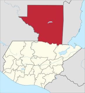
Petén is a department of the Republic of Guatemala. It is geographically the northernmost department of Guatemala, as well as the largest by area — at 13,843 sq mi (35,854 km2) it accounts for about one third of Guatemala's area. The capital is Flores. The population at the 2002 Census was 366,735; the latest official estimate as of mid-2012 was 662,779.

The Chʼol (Chol) language is a member of the western branch of the Mayan language family used by the Chʼol people in the Mexican state of Chiapas. There are two main dialects:

Spanish conquest of Guatemala protracted conflict during the Spanish colonization of the Americas, in which Spanish colonisers gradually incorporated the territory that became the modern country of Guatemala into the colonial Viceroyalty of New Spain

The Spanish conquest of Guatemala was a protracted conflict during the Spanish colonization of the Americas, in which Spanish colonisers gradually incorporated the territory that became the modern country of Guatemala into the colonial Viceroyalty of New Spain. Before the conquest, this territory contained a number of competing Mesoamerican kingdoms, the majority of which were Maya. Many conquistadors viewed the Maya as "infidels" who needed to be forcefully converted and pacified, disregarding the achievements of their civilization. The first contact between the Maya and European explorers came in the early 16th century when a Spanish ship sailing from Panama to Santo Domingo was wrecked on the east coast of the Yucatán Peninsula in 1511. Several Spanish expeditions followed in 1517 and 1519, making landfall on various parts of the Yucatán coast. The Spanish conquest of the Maya was a prolonged affair; the Maya kingdoms resisted integration into the Spanish Empire with such tenacity that their defeat took almost two centuries.

Tactic, Guatemala Municipality in Alta Verapaz, Guatemala

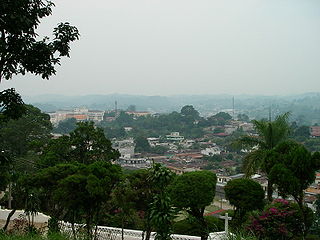
Tactic is a municipality in the Guatemalan department of Alta Verapaz. It is situated at 1,465 m above sea level. It has a population of 27,555, and covers a terrain of 85 km². The languages spoken in Tactic are predominantly Spanish, Poqomchi', and Q'eqchi'.

Santa Maria Nebaj Municipality in El Quiché, Guatemala

Santa Maria Nebaj is a municipality in the Guatemalan department of El Quiché. Santa Maria Nebaj is part of the Ixil Community, along with San Juan Cotzal and San Gaspar Chajul. Native residents speak the Mayan Ixil language.

Zacpeten

Zacpeten is a pre-Columbian Maya archaeological site in the northern Petén Department of Guatemala. It is notable as one of the few Maya communities that maintained their independence through the early phases of Spanish control over Mesoamerica.

Indian auxiliaries Indigenous peoples of the Americas who aligned with the Spanish conquest

Indian auxiliaries or indios auxiliares is the term used in old Spanish chronicles and historical texts for the indigenous peoples who were integrated into the armies of the Spanish conquistadors with the purpose of supporting their advance and combat operations during the Conquest of America. They acted as guides, translators, or porters and in this role were also called yanakuna, particularly within the old Inca Empire and Chile. The term was also used for formations composed of indigenous warriors or Indios amigos, which they used for reconnaissance, combat, and as reserve in battle. The auxiliary Indians remained in use after the conquest, during some revolts, in border zones and permanent military areas, as in Chile in the Arauco War.

The Chuj or Chuh are a Maya people, whose homeland is in Guatemala and Mexico. Population estimates vary between 30,000 and over 60,000. Their indigenous language is also called Chuj and belongs to the Q'anjobalan branch of Mayan languages. In Guatemala, most Chuj live in the department of Huehuetenango in the municipalities of San Mateo Ixtatán and San Sebastián Coatán.

Spanish conquest of the Maya Conquest dating from 1511 to 1697

The Spanish conquest of the Maya was a protracted conflict during the Spanish colonisation of the Americas, in which the Spanish conquistadores and their allies gradually incorporated the territory of the Late Postclassic Maya states and polities into the colonial Viceroyalty of New Spain. The Maya occupied a territory that is now incorporated into the modern countries of Mexico, Guatemala, Belize, Honduras and El Salvador; the conquest began in the early 16th century and is generally considered to have ended in 1697.

Yalain

The Yalain have been proposed as a Maya polity that existed during the Postclassic period in the Petén Basin of northern Guatemala, based in the central Petén lakes region. A small town called Yalain was described in 1696 by the Franciscan friar Andrés de Avendaño y Loyola. It was said to consist of a relatively small number of residences clustered within rich agricultural land. The town was located to the east of Lake Petén Itzá and was said to have been farmed by the inhabitants of Nojpetén, the capital city of the Itza kingdom. The political extent and archaeology of the Yalain is poorly understood.

Spanish conquest of Petén

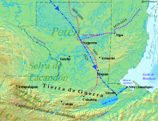
The Spanish conquest of Petén was the last stage of the conquest of Guatemala, a prolonged conflict during the Spanish colonisation of the Americas. A wide lowland plain covered with dense rainforest, Petén contains a central drainage basin with a series of lakes and areas of savannah. It is crossed by several ranges of low karstic hills and rises to the south as it nears the Guatemalan Highlands. The conquest of Petén, a region now incorporated into the modern republic of Guatemala, climaxed in 1697 with the capture of Nojpetén, the island capital of the Itza kingdom, by Martín de Ursúa y Arizmendi. With the defeat of the Itza, the last independent and unconquered native kingdom in the Americas fell to European colonisers.

Human sacrifice in Maya culture

During the pre-Columbian era, human sacrifice in Maya culture was the ritual offering of nourishment to the gods. Blood was viewed as a potent source of nourishment for the Maya deities, and the sacrifice of a living creature was a powerful blood offering. By extension, the sacrifice of a human life was the ultimate offering of blood to the gods, and the most important Maya rituals culminated in human sacrifice. Generally only high status prisoners of war were sacrificed, with lower status captives being used for labour.

Peten Itza kingdom

The Peten Itza kingdom was a kingdom centered on the island-city of Nojpetén on Lake Peten Itza.

Manche Chʼol

The Manche Chʼol were a former Chʼol-speaking Maya people inhabiting the extreme south of what is now the Petén Department of modern Guatemala, the area around Lake Izabal, and southern Belize. The Manche Chʼol took the name Manche from the name of their main settlement. They were the last group of eastern Cholan-speakers to remain independent and ethnically distinct. It is likely that they were descended from the inhabitants of Classic period Maya cities in the southeastern Maya region, such as Nim Li Punit, Copán and Quiriguá.

Acala Chʼol

The Acala Chʼol were a former Chʼol-speaking Maya people who occupied a territory to the west of the Manche Chʼol and east of the Chixoy River in what is now the Alta Verapaz Department of Guatemala. The Acala should not be confused with the people of the former Maya territory of Acalan, near the Laguna de Terminos in Mexico.

History of the Maya civilization

The history of Maya civilization is divided into three principal periods: the Preclassic, Classic and Postclassic periods; these were preceded by the Archaic Period, which saw the first settled villages and early developments in agriculture. Modern scholars regard these periods as arbitrary divisions of chronology of the Maya civilization, rather than indicative of cultural evolution or decadence. Definitions of the start and end dates of period spans can vary by as much as a century, depending on the author. The Preclassic lasted from approximately 2000 BC to approximately 250 AD; this was followed by the Classic, from 250 AD to roughly 950 AD, then by the Postclassic, from 950 AD to the middle of the 16th century. Each period is further subdivided:

References

Caso Barrera, Laura; Mario Aliphat (2007). J.P. Laporte; B. Arroyo; H. Mejía, eds. "Relaciones de Verapaz y las Tierras Bajas Mayas Centrales en el siglo XVII" (PDF). XX Simposio de Investigaciones Arqueológicas en Guatemala, 2006. Guatemala City, Guatemala: Museo Nacional de Arqueología y Etnología: 48–58. OCLC   173275417. Archived from the original (PDF) on 2013-10-17. Retrieved 2012-01-22. (in Spanish)
Eroza Solana; Enrique (2006). Lancandones. Pueblos indígenas del México contemporáneo. Mexico City, Mexico: Comisión Nacional para el Desarollo de los Pueblos Indígenas. ISBN   970-753-049-9. OCLC   71844580. (in Spanish)
Houwald, Götz von (1984). "Mapa y Descripción de la Montaña del Petén e Ytzá. Interpretación de un documento de los años un poco después de la conquista de Tayasal" (PDF). Indiana. Berlin, Germany: Ibero-Amerikanisches Institut (9). ISSN   0341-8642. OCLC   2452883 . Retrieved 2013-10-25. (in Spanish)
Jones, Grant D. (1998). The Conquest of the Last Maya Kingdom. Stanford, California, USA: Stanford University Press. ISBN   9780804735223. 
Jones, Grant D. (2000). "The Lowland Maya, from the Conquest to the Present". In Richard E.W. Adams; Murdo J. Macleod. The Cambridge History of the Native Peoples of the Americas, Vol. II: Mesoamerica, part 2. Cambridge, UK: Cambridge University Press. pp. 346–391. ISBN   0-521-65204-9. OCLC   33359444. 
Limón Aguirre, Fernando (2008). "La ciudadanía del pueblo chuj en México: Una dialéctica negativa de identidades" (PDF). San Cristóbal de Las Casas, Mexico: El Colegio de la Frontera Sur – Unidad San Cristóbal de Las Casas. Archived from the original (PDF) on 2012-04-02. Retrieved 2013-10-25. (in Spanish)
Lovell, W. George (2000). "The Highland Maya". In Richard E.W. Adams; Murdo J. Macleod. The Cambridge History of the Native Peoples of the Americas, Vol. II: Mesoamerica, part 2. Cambridge, UK: Cambridge University Press. pp. 392–444. ISBN   0-521-65204-9. OCLC   33359444. 
Lovell, W. George (2005). Conquest and Survival in Colonial Guatemala: A Historical Geography of the Cuchumatán Highlands, 1500–1821 (3rd ed.). Montreal, Canada: McGill-Queen's University Press. ISBN   0-7735-2741-9. OCLC   58051691. 
Pons Sáez, Nuria (1997). La Conquista del Lacandón. Mexico: Universidad Nacional Autónoma de México. ISBN   968-36-6150-5. OCLC   40857165. (in Spanish)
Pugh, Timothy W. (2009). "The Kowoj and the Lacandon: Migrations and Identities". In Prudence M. Rice; Don S. Rice. The Kowoj: identity, migration, and geopolitics in late postclassic Petén, Guatemala. Boulder, Colorado, US: University Press of Colorado. pp. 368–384. ISBN   978-0-87081-930-8. OCLC   225875268. 
Thompson, J. Eric S. (October–December 1938). "Sixteenth and Seventeenth Century Reports on the Chol Mayas". American Anthropologist. New Series. Wiley on behalf of the American Anthropological Association. 40 (4 (Part 1)): 584–604. doi:10.1525/aa.1938.40.4.02a00040. JSTOR   661615. (subscription required)
Vos, Jan de (1996) [1980]. La paz de Dios y del Rey: La conquista de la Selva Lacandona (1525-1821). Mexico City, Mexico: Secretaría de Educación y Cultura de Chiapas/Fondo de Cultura Económica. ISBN   968-16-3049-1. OCLC   20747634. (in Spanish)
Webre, Stephen (2004). "Política, evangelización y guerra: Fray Antonio Margil de Jesús y la frontera centroamericana, 1684–1706". VII Congreso Centroamericano de Historia, Universidad Nacional Autónoma de Honduras, Tegucigalpa, 19–23 July 2004. San José, Costa Rica: Universidad de Costa Rica, Escuela de Historia. Archived from the original (DOC) on 2 November 2014. Retrieved 2012-12-09. (in Spanish)