Arcola is an unincorporated community and census-designated place in Lake Township, Allen County, in the U.S. state of Indiana. The population of the community is 33.
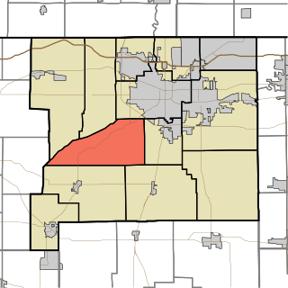
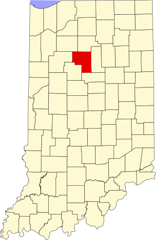
Greene Township is one of thirteen townships in St. Joseph County, in the U.S. state of Indiana. As of the 2000 census, its population was 3,040.

Tri-Lakes is an unincorporated community and census-designated place in Thorncreek and Smith townships in Whitley County, Indiana, United States.
Hobbs is an unincorporated community in Madison Township, Tipton County, in the U.S. state of Indiana.
Lake Cicott is an unincorporated community in Jefferson Township, Cass County, Indiana. The community is named after the lake in which it sits beside.
Lake Bruce is an unincorporated community and census-designated place (CDP) in Union Township, Fulton County, Indiana. It was named after the 245-acre lake nearby.
Fish Lake is an unincorporated community and census-designated place in Lincoln Township, LaPorte County, Indiana, United States. It is located where Indiana State Road 4 passes between Upper Fish Lake and Lower Fish Lake. These lakes feed the Kankakee River. As of the 2010 census, the population of the community was 1,016.

Hudson Lake is an unincorporated community and census-designated place (CDP) in Hudson Township, LaPorte County, Indiana, United States. The town sits on the dividing line between Central and Eastern time zones. It is the site of the Hudson Lake station stop of the South Shore Line. As of the 2010 census, the population of the CDP was 1,297.
Bear Lake is a lakeside community in Noble Township, Noble County, in the U.S. state of Indiana. Points of interest include Bear Lake Camp, Bear Lake Church, Elwood H. Thomas Public Beach, and Merry Lea Environmental Center.
Lake Santee is an unincorporated town and census-designated place in Decatur and Franklin counties, Indiana, United States. As of the 2010 census, it had a population of 820.

Shorewood Forest is a census-designated place (CDP) in Union Township, Porter County, in the U.S. state of Indiana. The community centers on Lake Louise, an artificial water body. The population of the CDP was 2,708 at the 2010 census.

Cordry Sweetwater Lakes is a census-designated place (CDP) in Hamblen Township, Brown County, in the U.S. state of Indiana. The population was 1,128 at the 2010 census. Sweetwater Lake is 260 acres in size.
Bennetts Switch is an unincorporated community and census-designated place (CDP) in Deer Creek Township, Miami County, in the U.S. state of Indiana.
Country Squire Lakes is an unincorporated community and census-designated place (CDP) in Geneva Township, Jennings County, Indiana, United States. As of the 2010 census it had a population of 3,571.
Chain-O-Lakes is an unincorporated community in Warren Township, St. Joseph County, in the U.S. state of Indiana.

Heritage Lake is an unincorporated community and census-designated place in Floyd Township, Putnam County, in the U.S. state of Indiana. Its population was 2,880 as of the 2010 census. The community is located in eastern Putnam County on the shores of its namesake lake. The lake is 318 acres in size.

Van Bibber Lake is an unincorporated town and census-designated place in Clinton Township, Putnam County, in the U.S. state of Indiana. Its population was 485 as of the 2010 census. The community is located on the shores of Glenn Flint Lake and its namesake lake.

Painted Hills is an unincorporated community and census-designated place (CDP) in Jackson Township, Morgan County, in the U.S. state of Indiana. Its population was 766 as of the 2020 census, up from 677 in 2010. The community is located on the shores of Lake Holiday and Lake Nebo southeast of Martinsville, the Morgan county seat. The two lakes are a combined 196 acres (79 ha) in size.

Grandview Lake is an platted town and census-designated place in Ohio Township, Bartholomew County, in the U.S. state of Indiana. It shares its name with the lake at its center. It was largely developed in the 1960s.
Eagle Lake is an unincorporated community and census-designated place (CDP) in Will County, Illinois, United States. It is near the southeast corner of the county, in the northeast corner of Washington Township. It is 5 miles (8 km) northeast of Beecher and 1.5 miles (2.4 km) west of the Indiana state line.


