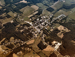
Oldenburg, Indiana

Last updated

Oldenburg, Indiana
Oldenburg, Indiana.jpg
Franklin County Indiana Incorporated and Unincorporated areas Oldenburg Highlighted 1856286.svg
Location of Oldenburg in Franklin County, Indiana.
Coordinates: 39°20′20″N85°12′15″W / 39.33889°N 85.20417°W / 39.33889; -85.20417
Country United States
State Indiana
County Franklin
Township Ray
Area
[1]
  Total0.43 sq mi (1.12 km2)
  Land0.43 sq mi (1.11 km2)
  Water0.00 sq mi (0.01 km2)
Elevation
[2]
879 ft (268 m)
Population
 (2020)
  Total647
  Density1,504.65/sq mi (581.15/km2)
Time zone UTC-5 (Eastern (EST))
  Summer (DST) UTC-4 (EDT)
ZIP code
47036
Area code 812
FIPS code 18-56286 [3]
GNIS feature ID2396831 [2]
Website www.freudenfest.com

Oldenburg is a town in Ray Township, Franklin County, Indiana, United States. The population was 674 at the 2010 census.

Contents

Geography

According to the 2010 census, Oldenburg has a total area of 0.43 square miles (1.11 km2), all land. [4]

History

Interior of Holy Family Catholic Church in Oldenburg Holy Family Catholic Church (Oldenburg, Indiana) - interior, nave before a wedding Mass.jpg
Interior of Holy Family Catholic Church in Oldenburg

Oldenburg was founded in 1837 by a group of German settlers. [5] The town was named after Oldenburg, in Germany. [6] Incorporated in 1881, [7] Oldenburg is called the "Village of Spires" because of its churches and religious educational institutions. In 1851, Mother Theresa Hackelmeier (1827-1860) founded the Sisters of St. Francis of Oldenburg who would open numerous schools in the Midwest.

The Oldenburg Historic District was listed on the National Register of Historic Places in 1983. [8]

Fly-over view of Oldenburg Oldenburg-indiana-from-above.jpg
Fly-over view of Oldenburg

Demographics

Historical population
CensusPop.Note
1860 300
1870 160−46.7%
1880 673320.6%
1890 6902.5%
1900 95738.7%
1910 956−0.1%
1920 628−34.3%
1930 575−8.4%
1940 533−7.3%
1950 59110.9%
1960 69417.4%
1970 7589.2%
1980 7701.6%
1990 715−7.1%
2000 647−9.5%
2010 6744.2%
2020 647−4.0%
U.S. Decennial Census [9]

2010 census

As of the census [10] of 2010, there were 674 people, 235 households, and 156 families living in the town. The population density was 1,567.4 inhabitants per square mile (605.2/km2). There were 268 housing units at an average density of 623.3 per square mile (240.7/km2). The racial makeup of the town was 98.5% White, 0.1% African American, 0.6% from other races, and 0.7% from two or more races. Hispanic or Latino of any race were 1.9% of the population.

There were 235 households, of which 30.6% had children under the age of 18 living with them, 52.3% were married couples living together, 10.6% had a female householder with no husband present, 3.4% had a male householder with no wife present, and 33.6% were non-families. 29.4% of all households were made up of individuals, and 14.9% had someone living alone who was 65 years of age or older. The average household size was 2.39 and the average family size was 2.97.

The median age in the town was 51 years. 20.6% of residents were under the age of 18; 5.8% were between the ages of 18 and 24; 17.3% were from 25 to 44; 26.7% were from 45 to 64; and 29.5% were 65 years of age or older. The gender makeup of the town was 39.3% male and 60.7% female.

2000 census

As of the census [3] of 2000, there were 647 people, 215 households, and 135 families living in the town. The population density was 1,554.2 inhabitants per square mile (600.1/km2). There were 228 housing units at an average density of 547.7 per square mile (211.5/km2). The racial makeup of the town was 98.92% White, 0.46% Asian, and 0.62% from two or more races. Hispanic or Latino of any race were 0.15% of the population.

There were 215 households, out of which 27.4% had children under the age of 18 living with them, 54.4% were married couples living together, 7.0% had a female householder with no husband present, and 37.2% were non-families. 34.4% of all households were made up of individuals, and 19.5% had someone living alone who was 65 years of age or older. The average household size was 2.31 and the average family size was 3.01.

In the town, the population was spread out, with 17.3% under the age of 18, 5.1% from 18 to 24, 21.2% from 25 to 44, 21.8% from 45 to 64, and 34.6% who were 65 years of age or older. The median age was 49 years. For every 100 females, there were 63.0 males. For every 100 females age 18 and over, there were 55.5 males.

The median income for a household in the town was $42,292, and the median income for a family was $56,042. Males had a median income of $36,635 versus $28,571 for females. The per capita income for the town was $19,620. About 2.3% of families and 17.7% of the population were below the poverty line, including 1.8% of those under age 18 and 41.6% of those age 65 or over.

Notable natives of Oldenburg

Related Research Articles

<span class="mw-page-title-main">Dyer Brook, Maine</span> Town in the state of Maine, United States

Dyer Brook is a town in Aroostook County, Maine, United States. The population was 215 at the 2020 census. Dyer Brook is also host to the local school, Southern Aroostook Community School.

<span class="mw-page-title-main">Eagle Lake, Maine</span> Town in the state of Maine, United States

Eagle Lake is a town in Aroostook County, Maine, United States. The population was 772 at the 2020 census. The town was named by a body of troops heading from Bangor to the Aroostook War for the many eagles that they saw around the lake. A total of 49.0% of the population speaks French, reflecting a trend in Northeastern Maine.

<span class="mw-page-title-main">Littleton, Maine</span> Town in the state of Maine, United States

Littleton is a town in Aroostook County, Maine, United States. The population was 997 at the 2020 census.

<span class="mw-page-title-main">Merrill, Maine</span> Town in the state of Maine, United States

Merrill is a town in Aroostook County, Maine, United States. The population was 208 at the 2020 census.

<span class="mw-page-title-main">New Canada, Maine</span> Town in the state of Maine, United States

New Canada is a town in Aroostook County, Maine, United States. The population was 310 at the 2020 census.

<span class="mw-page-title-main">Oakfield, Maine</span> Town in the state of Maine, United States

Oakfield is a town in Aroostook County, Maine, United States. The population was 661 at the 2020 census. The village of Oakfield, listed as a census-designated place, is in the northwestern corner of the town.

<span class="mw-page-title-main">Perham, Maine</span> Town in the state of Maine, United States

Perham is a town in Aroostook County, Maine, United States. The population was 371 at the 2020 census. The town was named after Maine's 33rd governor, Sidney Perham.

<span class="mw-page-title-main">Sherman, Maine</span> Town in the state of Maine, United States

Sherman is a town in Aroostook County, Maine, United States. The population was 815 at the 2020 census.

<span class="mw-page-title-main">Stockholm, Maine</span> Town in the state of Maine, United States

Stockholm is a town in Aroostook County, Maine, United States. The population was 250 at the 2020 census.

<span class="mw-page-title-main">Westfield, Maine</span> Town in the state of Maine, United States

Westfield is a town in Aroostook County, Maine, United States. The population was 455 at the 2020 census.

<span class="mw-page-title-main">Chesterville, Maine</span> Town in Maine, United States

Chesterville is a town in Franklin County, Maine, United States. The population was 1,328 at the 2020 census.

Stoneham is a town in Oxford County, Maine, United States. The population was 261 at the 2020 census.

<span class="mw-page-title-main">Upton, Maine</span> Town in the state of Maine, United States

Upton is a town in Oxford County, Maine, United States. The population was 69 at the 2020 census.

Plymouth is a town in Penobscot County, Maine, United States. The population was 1,325 at the 2020 census.

Detroit is a town in Somerset County, Maine, United States. The population was 885 at the 2020 census.

Meddybemps is a town in Washington County, Maine, United States. The population was 139 at the 2020 census.

<span class="mw-page-title-main">Worthington, West Virginia</span> Town in West Virginia, United States

Worthington is a town in Marion County, West Virginia, United States. The population was 158 at the 2010 census. Worthington was incorporated in 1893 and named for Colonel George Worthington, an early settler. U.S. Route 19 passes through the town.

<span class="mw-page-title-main">Bancroft, West Virginia</span> Town in West Virginia, United States

Bancroft is a town in Putnam County, West Virginia, United States, along the Kanawha River. The population was 389 at the 2020 census. It is part of the Huntington–Ashland metropolitan area.

<span class="mw-page-title-main">Camden-on-Gauley, West Virginia</span> Town in West Virginia, United States

Camden-on-Gauley is a town in Webster County, West Virginia, United States, along the Gauley River. The population was 126 at the 2020 census.

<span class="mw-page-title-main">St. Albans, Maine</span> Town in the state of Maine, United States

St. Albans is a town in Somerset County, Maine, United States. The population was 2,045 at the 2020 census.

References

  1. "2020 U.S. Gazetteer Files". United States Census Bureau. Retrieved March 16, 2022.
  2. 1 2 U.S. Geological Survey Geographic Names Information System: Oldenburg, Indiana
  3. 1 2 "U.S. Census website". United States Census Bureau . Retrieved January 31, 2008.
  4. "G001 - Geographic Identifiers - 2010 Census Summary File 1". United States Census Bureau. Archived from the original on February 13, 2020. Retrieved July 17, 2015.
  5. Hunter, David (October 1, 2003). Shifra Stein's Day Trips from Cincinnati: Getaways Less Than Two Hours Away. Globe Pequot. p. 8. ISBN   9780762727490 . Retrieved April 26, 2013.
  6. "Oldenburg". Franklin County Historical Society. Retrieved July 23, 2015.
  7. Reifel, August Jacob (1915). History of Franklin County, Indiana. Windmill Publications. pp.  168.
  8. "National Register Information System". National Register of Historic Places . National Park Service. July 9, 2010.
  9. "Census of Population and Housing". Census.gov. Retrieved June 4, 2015.
  10. "U.S. Census website". United States Census Bureau . Retrieved December 11, 2012.