Laurel, Indiana

Last updated

Laurel, Indiana
Laurel, Indiana.jpg
Franklin County Indiana Incorporated and Unincorporated areas Laurel Highlighted 1842372.svg
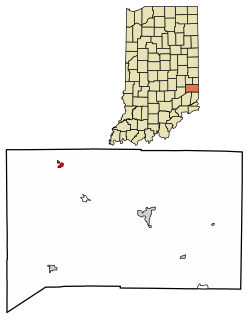
Location of Laurel in Franklin County, Indiana.
Coordinates: 39°30′01″N85°11′16″W / 39.50028°N 85.18778°W / 39.50028; -85.18778
Country United States
State Indiana
County Franklin
Township Laurel
Area
[1]
  Total0.24 sq mi (0.62 km2)
  Land0.24 sq mi (0.62 km2)
  Water0.00 sq mi (0.00 km2)
Elevation
[2]
728 ft (222 m)
Population
 (2020)
  Total406
  Density1,705.88/sq mi (658.58/km2)
Time zone UTC-5 (Eastern (EST))
  Summer (DST) UTC-4 (EDT)
ZIP code
47024
Area code 765
FIPS code 18-42372 [3]
GNIS feature ID2396710 [2]

Laurel is a town in Laurel Township, Franklin County, Indiana, United States. The population was 512 at the 2010 census.

Contents

History

Laurel was platted in 1836 by James Conwell, a native of Maryland. Conwell had first intended to name his settlement New Baltimore, but instead decided to call it Laurel, after the city of Laurel, Maryland. [4] The last wild passenger pigeon, once the most common bird in North America, was shot near Laurel in 1902. [5]

The Laurel post office was established in 1837. [6]

Geography

According to the 2010 census, Laurel has a total area of 0.24 square miles (0.62 km2), all land. [7]

Demographics

Historical population
CensusPop.Note
1860 670
1870 74110.6%
1880 670−9.6%
1900 600
1910 503−16.2%
1920 5152.4%
1930 5160.2%
1940 5333.3%
1950 68027.6%
1960 84824.7%
1970 753−11.2%
1980 8198.8%
1990 544−33.6%
2000 5796.4%
2010 512−11.6%
2020 406−20.7%
U.S. Decennial Census [8]

2010 census

As of the census [9] of 2010, there were 512 people, 196 households, and 134 families living in the town. The population density was 2,133.3 inhabitants per square mile (823.7/km2). There were 227 housing units at an average density of 945.8 per square mile (365.2/km2). The racial makeup of the town was 98.4% White, 0.2% African American, 0.6% Native American, 0.2% from other races, and 0.6% from two or more races. Hispanic or Latino of any race were 2.5% of the population.

There were 196 households, of which 38.3% had children under the age of 18 living with them, 39.3% were married couples living together, 18.9% had a female householder with no husband present, 10.2% had a male householder with no wife present, and 31.6% were non-families. 23.0% of all households were made up of individuals, and 10.7% had someone living alone who was 65 years of age or older. The average household size was 2.61 and the average family size was 3.08.

The median age in the town was 34.8 years. 27% of residents were under the age of 18; 10.4% were between the ages of 18 and 24; 27.9% were from 25 to 44; 21% were from 45 to 64; and 13.7% were 65 years of age or older. The gender makeup of the town was 51.0% male and 49.0% female.

2000 census

As of the census [3] of 2000, there were 579 people, 201 households, and 155 families living in the town. The population density was 2,434.6 inhabitants per square mile (940.0/km2). There were 220 housing units at an average density of 925.1 per square mile (357.2/km2). The racial makeup of the town was 98.96% White, 0.17% from other races, and 0.86% from two or more races. Hispanic or Latino of any race were 1.21% of the population.

There were 201 households, out of which 41.3% had children under the age of 18 living with them, 55.7% were married couples living together, 13.4% had a female householder with no husband present, and 22.4% were non-families. 17.9% of all households were made up of individuals, and 8.0% had someone living alone who was 65 years of age or older. The average household size was 2.88 and the average family size was 3.21.

In the town, the population was spread out, with 31.4% under the age of 18, 10.4% from 18 to 24, 29.5% from 25 to 44, 18.1% from 45 to 64, and 10.5% who were 65 years of age or older. The median age was 30 years. For every 100 females there were 104.6 males. For every 100 females age 18 and over, there were 96.5 males.

The median income for a household in the town was $29,375, and the median income for a family was $33,625. Males had a median income of $28,846 versus $20,625 for females. The per capita income for the town was $12,035. About 11.6% of families and 13.6% of the population were below the poverty line, including 11.5% of those under age 18 and 22.8% of those age 65 or over.

Education

Laurel has a public library, a branch of the Franklin County Public Library District. [10]

Notable people

See also

Related Research Articles

<span class="mw-page-title-main">St. Paul, Indiana</span> Town in Indiana, United States

St. Paul or Saint Paul is a small town on the border of Decatur and Shelby counties in the U.S. state of Indiana. The population was 1,031 at the 2010 census.

<span class="mw-page-title-main">Ashley, Indiana</span> Town in Indiana, United States

Ashley is a town in Indiana located on the border of Smithfield Township, DeKalb County and Steuben Township, Steuben County. The population was 983 at the 2010 census.

<span class="mw-page-title-main">Brookville, Indiana</span> Town in Indiana, United States

Brookville is a town in Brookville Township, Franklin County, Indiana, United States. The town is the county seat of and the largest community entirely within Franklin County. The population was 2,596 at the 2010 census.

<span class="mw-page-title-main">Cedar Grove, Indiana</span> Town in Indiana, United States

Cedar Grove is a town in Highland Township, Franklin County, Indiana, United States. The population was 156 at the 2010 census.

<span class="mw-page-title-main">Mount Carmel, Indiana</span> Town in Indiana, United States

Mount Carmel is a town in Springfield Township, Franklin County, Indiana, United States. The population was 86 at the 2010 census.

<span class="mw-page-title-main">Oldenburg, Indiana</span> Town in Indiana, United States

Oldenburg is a town in Ray Township, Franklin County, Indiana, United States. The population was 674 at the 2010 census.

<span class="mw-page-title-main">Lanesville, Indiana</span> Town in Indiana, United States

Lanesville is a town in Franklin Township, Harrison County, Indiana, United States. The population was 935 at the 2010 census.

<span class="mw-page-title-main">Stilesville, Indiana</span> Town in Indiana, United States

Stilesville is a town in Franklin Township, Hendricks County, Indiana, United States. The population was 316 at the 2010 Census.

<span class="mw-page-title-main">Andrews, Indiana</span> Town in Indiana, United States

Andrews is a town in Dallas Township, Huntington County, Indiana, United States. The population was 1,048 at the 2020 census.

<span class="mw-page-title-main">Bargersville, Indiana</span> Town in Indiana, United States

Bargersville is a town in White River and Union townships, Johnson County, Indiana, United States. The population was 9,560 at the 2020 census.

<span class="mw-page-title-main">Whiteland, Indiana</span> Town in Indiana, United States

Whiteland is a town in Pleasant, Franklin and Clark townships, Johnson County, Indiana, United States. The population was 4,599 at the 2020 census.

<span class="mw-page-title-main">Mentone, Indiana</span> Town in Indiana, United States

Mentone is a town in Harrison and Franklin townships, Kosciusko County, in the U.S. state of Indiana. Mentone is the self-proclaimed "Egg Basket of the Midwest" because of prolific commercial egg production in the area, and holds an Egg Festival annually in early June to celebrate its heritage. A large concrete egg stands near the town center and is considered locally to be the "Largest Egg in the World". The Lawrence D. Bell Aircraft Museum, is located within the town limits. The Popular Rotorcraft Association has its home at the PRA Mentone Airport C92) and is home to their annual fly-in convention.

<span class="mw-page-title-main">Pierceton, Indiana</span> Town in Indiana, United States

Pierceton is a town in Washington Township, Kosciusko County, in the U.S. state of Indiana. The population was 928 at the 2020 census.

<span class="mw-page-title-main">Brooklyn, Indiana</span> Town in Indiana, United States

Brooklyn is a town in Clay and Brown townships, Morgan County, Indiana, United States. The population was 2,511 at the 2020 census, up from 1,598 in 2010.

<span class="mw-page-title-main">Paragon, Indiana</span> Town in Indiana, United States

Paragon is a town in Ray Township, Morgan County, in the U.S. state of Indiana. The population was 556 at the 2020 census, down from 659 in 2010.

<span class="mw-page-title-main">Roachdale, Indiana</span> Town in Indiana, United States

Roachdale is a town in Franklin and Jackson townships, Putnam County, in the U.S. state of Indiana. The population was 926 at the 2010 census.

<span class="mw-page-title-main">Ridgeville, Indiana</span> Town in Indiana, United States

Ridgeville is a town in Franklin Township, Randolph County, Indiana, United States, along the Mississinewa River. The population was 688 at the 2020 census.

<span class="mw-page-title-main">Napoleon, Indiana</span> Town in Indiana, United States

Napoleon is a town in Jackson Township, Ripley County, in the U.S. state of Indiana. The population was 234 at the 2010 census.

<span class="mw-page-title-main">Hudson, Indiana</span> Town in Indiana, United States

Hudson is a town in Salem and Steuben townships, Steuben County, in the U.S. state of Indiana. The population was 518 at the 2010 census.

<span class="mw-page-title-main">Chesterville, Maine</span> Town in Maine, United States

Chesterville is a town in Franklin County, Maine, United States. The population was 1,328 at the 2020 census.

References

  1. "2020 U.S. Gazetteer Files". United States Census Bureau. Retrieved March 16, 2022.
  2. 1 2 U.S. Geological Survey Geographic Names Information System: Laurel, Indiana
  3. 1 2 "U.S. Census website". United States Census Bureau . Retrieved January 31, 2008.
  4. Reifel, August Jacob (1915). History of Franklin County, Indiana. Windmill Publications. pp.  180.
  5. "Project Passenger Pigeon / Indiana" . Retrieved October 2, 2019.
  6. "Franklin County". Jim Forte Postal History. Retrieved September 7, 2014.
  7. "G001 - Geographic Identifiers - 2010 Census Summary File 1". United States Census Bureau. Archived from the original on February 13, 2020. Retrieved July 17, 2015.
  8. "Census of Population and Housing". Census.gov. Retrieved June 4, 2015.
  9. "U.S. Census website". United States Census Bureau . Retrieved December 11, 2012.
  10. "Policies". Franklin County Public Library District. Retrieved March 7, 2018.