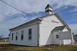
Andersonville, Indiana

Last updated

Andersonville, Indiana
Andersonville Christian Church.jpg
Andersonville Christian Church
USA Indiana location map.svg
Red pog.svg
Andersonville
Coordinates: 39°29′58″N85°17′10″W / 39.49944°N 85.28611°W / 39.49944; -85.28611
Country Flag of the United States.svg  United States
State Flag of Indiana.svg  Indiana
County Franklin County
Township Posey Township
Elevation
[1]
318 m (1,043 ft)
ZIP code
47024
GNIS feature ID2830375 [1]

Andersonville is an unincorporated community in Posey Township in the northwest corner of Franklin County, Indiana, United States.

Contents

History

On October 17, 1820 the government granted 160 acres to John and Simeon Barber/Barbour. Andersonville, the original town known as Ceylon, was laid out in Oct 1831 by Simeon Barber in 1831. It was 78 lots. The original streets (in use today) were laid out 66 feet wide and alleys were 16+12 feet wide. The Anderson Addition was laid out by Joel (Joseph) Anderson and Fletcher Tevis in 1837 with additional lots and streets. Anderson P.O. was established. The two additions merged and it was renamed in 1849 after Thomas Anderson, a tavern owner. In 1915, Andersonville had about 350 inhabitants. [2]

Geography

Andersonville is located at an elevation of 1050 feet. It lies at the intersection of U.S. Route 52 and the east end of Indiana State Road 244; this forms an acute angle, and the named streets run north and south in the triangle thus formed.

Related Research Articles

<span class="mw-page-title-main">Andersonville, Georgia</span> City in Georgia, United States

Andersonville is a city in Sumter County, Georgia, United States. As of the 2020 census, the city had a population of 237. It is located in the southwest part of the state, approximately 60 miles (97 km) southwest of Macon on the Central of Georgia railroad. During the American Civil War, it was the site of a prisoner-of-war camp, which is now Andersonville National Historic Site.

<span class="mw-page-title-main">Franklin County, Indiana</span> County in Indiana, United States

Franklin County is a county on the eastern border of the U.S. state of Indiana. In the 2020 United States Census, the county population was 22,785. The county seat is the town of Brookville. Franklin County is part of the Cincinnati, OH–KY–IN Metropolitan Statistical Area. The only incorporated city in Franklin County is Batesville, which lies mostly in adjoining Ripley County.

<span class="mw-page-title-main">Colfax, Illinois</span> Village in Illinois, United States

Colfax is a village in McLean County, Illinois, United States. The population was 996 at the 2020 census. It is part of the Bloomington–Normal Metropolitan Statistical Area.

<span class="mw-page-title-main">Hudson, Illinois</span> Village in Illinois, United States

Hudson is a village in McLean County, Illinois, United States. The population was 1,753 at the 2020 census. It is part of the Bloomington–Normal Metropolitan Statistical Area.

<span class="mw-page-title-main">Westport, Indiana</span> Town in Indiana, United States

Westport is a town located in Sand Creek Township, Decatur County, Indiana. The population was 1,379 at the 2010 census. A covered bridge, built in 1880, is located about 1.5 miles east of town.

<span class="mw-page-title-main">Pendleton, Indiana</span> Town in Indiana, United States

Pendleton is a town in Fall Creek Township, Madison County, Indiana, United States. The population was 4,717 at the 2020 census, up from 4,253 in 2010.

<span class="mw-page-title-main">Andersonville Prison</span> Site of former Confederate prisoner-of-war camp in Macon County, Georgia

The Andersonville National Historic Site, located near Andersonville, Georgia, preserves the former Andersonville Prison, a Confederate prisoner-of-war camp during the final fourteen months of the American Civil War. Most of the site lies in southwestern Macon County, adjacent to the east side of the town of Andersonville. The site also contains the Andersonville National Cemetery and the National Prisoner of War Museum. The prison was created in February 1864 and served until April 1865.

<span class="mw-page-title-main">Mounds State Park</span> State park in Indiana, United States

Mounds State Park is a state park near Anderson, Madison County, Indiana featuring Native American heritage, and ten ceremonial mounds built by the prehistoric Adena culture indigenous peoples of eastern North America, and also used centuries later by Hopewell culture inhabitants. It is separate from the similarly named Mounds State Recreation Area. The park receives about 400,000 visitors annually.

George L. Kinnard was a Representative from Indiana; born in Pennsylvania in 1803; moved with his widowed mother to Tennessee and completed preparatory studies; moved to Indianapolis, Ind., in 1823; studied law; was admitted to the bar and practised in Marion County, Indiana; assessor for Marion County in 1826 and 1827; member of the State house of representatives 1827–1830; county surveyor 1831–1835; colonel of the State militia; elected as a Jacksonian to the Twenty-third and Twenty-fourth Congresses and served from March 4, 1833, until his death on November 26, 1836; interment probably in Presbyterian Burying Ground, Cincinnati, Ohio.

<span class="mw-page-title-main">Posey Township, Franklin County, Indiana</span> Township in Indiana, United States

Posey Township is one of thirteen townships in Franklin County, Indiana, United States. As of the 2010 census, its population was 1,051.

<span class="mw-page-title-main">Temple Lot</span> First Latter Day Saints temple location

The Temple Lot, located in Independence, Missouri, is the first site to be dedicated for the construction of a temple in the Latter Day Saint movement. The area was dedicated on August 3, 1831, by the movement's founder, Joseph Smith. It was purchased on December 19, 1831, by Edward Partridge to be the center of the New Jerusalem or "City of Zion" after Smith said he received a revelation stating that it would be the gathering spot of the Latter Day Saints during the last days.

<span class="mw-page-title-main">Mount Healthy, Indiana</span> Unincorporated community in Indiana, United States

Mount Healthy is an unincorporated community in Jackson Township, Bartholomew County, in the U.S. state of Indiana.

The Reno Gang, also known as the Reno Brothers Gang and The Jackson Thieves, were a group of criminals that operated in the Midwestern United States during and just after the American Civil War. Though short-lived, the gang carried out the first three peacetime train robberies in U.S. history. Most of the stolen money was never recovered.

Barbersville was an unincorporated town in Shelby Township, Jefferson County, Indiana. Nothing remains of its few buildings.

<span class="mw-page-title-main">Parkridge, Knoxville</span> United States historic place

Parkridge is a neighborhood in Knoxville, Tennessee, United States, located off Magnolia Avenue east of the city's downtown area. Developed as a streetcar suburb for Knoxville's professional class in the 1890s, the neighborhood was incorporated as the separate city of Park City in 1907, and annexed by Knoxville in 1917. In the early 1900s, the neighborhood provided housing for workers at the nearby Standard Knitting Mill factory.

<span class="mw-page-title-main">Statue of Benjamin Franklin (Washington, D.C.)</span>

The outdoor statue of Benjamin Franklin in Washington, D.C., is located near the intersection of 12th Street and Pennsylvania Avenue, in front of the Old Post Office. The statue was a gift from Stilson Hutchins, founder of The Washington Post, who wanted to display his and the newspaper's stature in the city. The designer, Ernst Plassmann, and sculptor, Jacques Jouvenal, were both German-American artists. The architect of the memorial was J. F. Manning.

<span class="mw-page-title-main">St. John the Evangelist Catholic Church (Indianapolis, Indiana)</span> Historic church in Indiana, United States

Saint John the Evangelist Catholic Church is a Roman Catholic parish of the Archdiocese of Indianapolis in Indianapolis, Indiana, United States. The parish's origins date to 1837, when it was first named Holy Cross parish. In 1850 it was renamed Saint John the Evangelist parish, and is the oldest Catholic parish in the city and in Marion County, Indiana. Considered the mother of the Catholic parishes in Indianapolis, it played an important role in development of the Catholic Church in the city. Saint John's Church served as the pro-cathedral of the diocese from 1878 until 1906; its rectory served as the bishop's residence and chancery from 1878 until 1892. In 1900 the church served as the site of first episcopal consecration held in Indianapolis.

Andersonville is a census-designated place in Ross County, in the U.S. state of Ohio. The population of the CPD was 778 at the 2020 census.

<span class="mw-page-title-main">Broad Street (Columbus, Ohio)</span> East-west street in Columbus, Ohio

Broad Street is a major thoroughfare in Central Ohio, predominantly in Franklin County and Columbus. It stretches east from West Jefferson at Little Darby Creek to Pataskala. The street is considered one of Columbus's two main roads, along with High Street.

<span class="mw-page-title-main">High Street (Columbus, Ohio)</span> North-south street in Columbus, Ohio

High Street is a major thoroughfare in Central Ohio, predominantly in Franklin County and Columbus. It stretches from the northern border of Columbus in Delaware County south to the southern boundary of Franklin County just past Columbus's municipal boundaries. The street is considered one of Columbus's two main roads, along with Broad Street.

References

  1. 1 2 U.S. Geological Survey Geographic Names Information System: Andersonville, Indiana
  2. Reifel, August Jacob (1915). History of Franklin County, Indiana. Windmill Publications. pp.  126.