Mount Carmel, Indiana

Last updated

Mount Carmel, Indiana
Mtcarmel, Indiana.jpg
Franklin County Indiana Incorporated and Unincorporated areas Mount Carmel Highlighted 1851354.svg
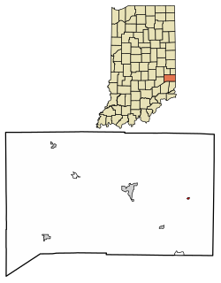
Location of Mount Carmel in Franklin County, Indiana.
Coordinates: 39°24′27″N84°52′29″W / 39.40750°N 84.87472°W / 39.40750; -84.87472
Country United States
State Indiana
County Franklin
Township Springfield
Area
[1]
  Total0.04 sq mi (0.11 km2)
  Land0.04 sq mi (0.11 km2)
  Water0.00 sq mi (0.00 km2)
Elevation
[2]
1,017 ft (310 m)
Population
 (2020)
  Total76
  Density1,727.27/sq mi (670.56/km2)
Time zone UTC-5 (Eastern (EST))
  Summer (DST) UTC-4 (EDT)
FIPS code 18-51354 [3]
GNIS feature ID2396788 [2]

Mount Carmel is a town in Springfield Township, Franklin County, Indiana, United States. The population was 86 at the 2010 census.

Contents

History

Mount Carmel was founded in 1837. [4] The town took its name from the Mt. Carmel Presbyterian Church. [5]

A post office was established at Mount Carmel in 1840, and remained in operation until it was discontinued in 1906. [6]

Geography

According to the 2010 census, Mount Carmel has a total area of 0.05 square miles (0.13 km2), all land. [7]

Demographics

Historical population
CensusPop.Note
1880 182
1890 142−22.0%
1900 1537.7%
1910 142−7.2%
1920 127−10.6%
1930 15018.1%
1940 120−20.0%
1950 13411.7%
1960 1426.0%
1970 128−9.9%
1980 15118.0%
1990 108−28.5%
2000 106−1.9%
2010 86−18.9%
2020 76−11.6%
U.S. Decennial Census [8]

2010 census

As of the census [9] of 2010, there were 86 people, 31 households, and 25 families living in the town. The population density was 1,720.0 inhabitants per square mile (664.1/km2). There were 32 housing units at an average density of 640.0 per square mile (247.1/km2). The racial makeup of the town was 97.7% White and 2.3% from two or more races.

There were 31 households, of which 45.2% had children under the age of 18 living with them, 54.8% were married couples living together, 22.6% had a female householder with no husband present, 3.2% had a male householder with no wife present, and 19.4% were non-families. 16.1% of all households were made up of individuals, and 6.4% had someone living alone who was 65 years of age or older. The average household size was 2.77 and the average family size was 2.96.

The median age in the town was 35 years. 31.4% of residents were under the age of 18; 11.7% were between the ages of 18 and 24; 23.3% were from 25 to 44; 22.1% were from 45 to 64; and 11.6% were 65 years of age or older. The gender makeup of the town was 45.3% male and 54.7% female.

2000 census

As of the census [3] of 2000, there were 106 people, 39 households, and 23 families living in the town. The population density was 2,526.0 inhabitants per square mile (975.3/km2). There were 41 housing units at an average density of 977.0 per square mile (377.2/km2). The racial makeup of the town was 99.06% White and 0.94% African American.

There were 39 households, out of which 33.3% had children under the age of 18 living with them, 48.7% were married couples living together, 10.3% had a female householder with no husband present, and 38.5% were non-families. 30.8% of all households were made up of individuals, and 15.4% had someone living alone who was 65 years of age or older. The average household size was 2.72 and the average family size was 3.42.

In the town, the population was spread out, with 28.3% under the age of 18, 18.9% from 18 to 24, 22.6% from 25 to 44, 17.9% from 45 to 64, and 12.3% who were 65 years of age or older. The median age was 28 years. For every 100 females, there were 82.8 males. For every 100 females age 18 and over, there were 90.0 males.

The median income for a household in the town was $25,000, and the median income for a family was $31,250. Males had a median income of $23,125 versus $17,250 for females. The per capita income for the town was $9,586. There were 28.1% of families and 27.0% of the population living below the poverty line, including 25.0% of under eighteens and 21.4% of those over 64.

Notable people

Related Research Articles

<span class="mw-page-title-main">St. Paul, Indiana</span> Town in Indiana, United States

St. Paul or Saint Paul is a small town on the border of Decatur and Shelby counties in the U.S. state of Indiana. The population was 1,031 at the 2010 census.

<span class="mw-page-title-main">Ashley, Indiana</span> Town in Indiana, United States

Ashley is a town in Indiana located on the border of Smithfield Township, DeKalb County and Steuben Township, Steuben County. The population was 983 at the 2010 census.

<span class="mw-page-title-main">Chesterfield, Indiana</span> Town in Indiana, United States

Chesterfield is a town in the U.S. state of Indiana which lies in Union Township, Madison County, and Salem Township, Delaware County. The population was 2,490 at the 2020 census. It is part of the Indianapolis–Carmel–Anderson metropolitan statistical area.

<span class="mw-page-title-main">Cicero, Indiana</span> Town in Indiana, United States

Cicero is a town in Jackson Township, Hamilton County, Indiana, United States, north of Indianapolis. The population was 4,812 at the 2010 census.

<span class="mw-page-title-main">Mount Summit, Indiana</span> Town in Indiana, United States

Mount Summit is a town in Prairie Township, Henry County, Indiana, United States. The population was 352 at the 2010 census.

<span class="mw-page-title-main">Mount Etna, Indiana</span> Town in Indiana, United States

Mount Etna is a town in Huntington County, Indiana, United States. The population was 94 at the 2010 census. It lies at the intersection of four townships: Jefferson, Lancaster, Polk and Wayne.

<span class="mw-page-title-main">Winona Lake, Indiana</span> Town in Indiana, United States

Winona Lake is a town in Wayne Township, Kosciusko County, in the U.S. state of Indiana, and the major suburb of Warsaw. The population was 4,908 at the 2010 census.

<span class="mw-page-title-main">St. John, Indiana</span> Town in Indiana, United States

St. John or Saint John is a town in Lake County, Indiana, United States. The town of St. John has homes in St. John Township, Hanover Township, and Center Township. St. John was founded in 1837. The population was 14,850 at the 2010 census. In 2009, St. John ranked 48th among CNN's top 100 places to live in the United States. In 2014, St. John was ranked as the 4th safest place in Indiana by Movoto Real Estate.

<span class="mw-page-title-main">Edgewood, Indiana</span> Town in Indiana, United States

Edgewood is a town in Anderson Township, Madison County, Indiana, United States. It is part of the Indianapolis–Carmel–Anderson metropolitan statistical area. The population was 2,053 at the 2020 census.

<span class="mw-page-title-main">Frankton, Indiana</span> Town in Indiana, United States

Frankton is a town in Pipe Creek and Lafayette townships, Madison County, Indiana, United States. It is part of the Indianapolis–Carmel–Anderson metropolitan statistical area. The population was 1,775 at the 2020 census.

<span class="mw-page-title-main">Ingalls, Indiana</span> Town in Indiana, United States

Ingalls is a town in Green Township, Madison County, Indiana, United States. It is part of the Indianapolis–Carmel–Anderson metropolitan statistical area. The population was 2,223 at the 2020 census.

<span class="mw-page-title-main">Lapel, Indiana</span> Town in Indiana, United States

Lapel is a town in Stony Creek and Green townships, Madison County, Indiana, United States. It is part of the Indianapolis–Carmel–Anderson metropolitan statistical area. The population was 2,325 at the 2020 census, up from 2,068 in 2010.

<span class="mw-page-title-main">Markleville, Indiana</span> Town in Indiana, United States

Markleville is a town in Adams Township, Madison County, Indiana, United States. It is part of the Indianapolis–Carmel–Anderson metropolitan statistical area. The population was 484 at the 2020 census.

<span class="mw-page-title-main">Summitville, Indiana</span> Town in Indiana, United States

Summitville is a town in Van Buren Township, Madison County, Indiana, United States. It is part of the Indianapolis–Carmel–Anderson metropolitan statistical area. The population was 989 at the 2020 census.

<span class="mw-page-title-main">Woodlawn Heights, Indiana</span> Town in Indiana, United States

Woodlawn Heights is a town in Anderson Township, Madison County, Indiana, United States. It is part of the Indianapolis–Carmel–Anderson metropolitan statistical area. The population was 91 at the 2020 census.

<span class="mw-page-title-main">Paragon, Indiana</span> Town in Indiana, United States

Paragon is a town in Ray Township, Morgan County, in the U.S. state of Indiana. The population was 556 at the 2020 census, down from 659 in 2010.

<span class="mw-page-title-main">Mount Ayr, Indiana</span> Town in Indiana, United States

Mount Ayr is a town in Jackson Township, Newton County, in the U.S. state of Indiana. The population was 122 at the 2010 census.

<span class="mw-page-title-main">Mount Auburn, Indiana</span> Town in Indiana, United States

Mount Auburn is a town in Jackson Township, Wayne County, in the U.S. state of Indiana. The population was 117 at the 2010 census. The town is sandwiched between Dublin and Cambridge City.

<span class="mw-page-title-main">Carmel, Maine</span> Town in the state of Maine, United States

Carmel is a town in Penobscot County, Maine, United States. It is part of the Bangor Metropolitan Statistical Area. The population was 2,867 at the 2020 census.

<span class="mw-page-title-main">Meridian Hills, Indiana</span> Town in Indiana, United States

Meridian Hills is a town in Washington Township, Marion County, Indiana, about 8 miles (13 km) north of downtown Indianapolis. It had a population of 1,774 at the 2020 census, up from 1,616 in 2010.

References

  1. "2020 U.S. Gazetteer Files". United States Census Bureau. Retrieved March 16, 2022.
  2. 1 2 U.S. Geological Survey Geographic Names Information System: Mount Carmel, Indiana
  3. 1 2 "U.S. Census website". United States Census Bureau . Retrieved January 31, 2008.
  4. Baker, Ronald L. (October 1995). From Needmore to Prosperity: Hoosier Place Names in Folklore and History . Indiana University Press. p.  229. ISBN   978-0-253-32866-3. This village was laid out on December 20, 1837...
  5. Reifel, August Jacob (1915). History of Franklin County, Indiana. Windmill Publications. pp.  146.
  6. "Franklin County". Jim Forte Postal History. Retrieved September 7, 2014.
  7. "G001 - Geographic Identifiers - 2010 Census Summary File 1". United States Census Bureau. Archived from the original on February 13, 2020. Retrieved July 17, 2015.
  8. "Census of Population and Housing". Census.gov. Retrieved June 4, 2015.
  9. "U.S. Census website". United States Census Bureau . Retrieved December 11, 2012.