Cedar Grove, Indiana

Last updated

Cedar Grove, Indiana
Town of Cedar Grove
Cedargrove, Indiana.jpg
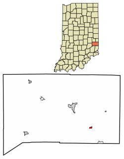
Franklin County Indiana Incorporated and Unincorporated areas Cedar Grove Highlighted 1811044.svg
Location of Cedar Grove in Franklin County, Indiana.
Coordinates: 39°21′22″N84°56′14″W / 39.35611°N 84.93722°W / 39.35611; -84.93722
Country United States
State Indiana
County Franklin
Township Highland
Area
[1]
  Total0.16 sq mi (0.41 km2)
  Land0.15 sq mi (0.39 km2)
  Water0.01 sq mi (0.02 km2)
Elevation
[2]
597 ft (182 m)
Population
 (2020)
  Total150
  Density993.38/sq mi (383.83/km2)
Time zone UTC-5 (EST)
  Summer (DST) UTC-5 (EST)
ZIP code
47016
Area code 765
FIPS code 18-11044 [3]
GNIS feature ID2396633 [2]

Cedar Grove is a town in Highland Township, Franklin County, Indiana, United States. The population was 156 at the 2010 census.

Contents

History

Cedar Grove, originally known as Rochester, was platted in 1837 by John Ward. Ward built a large gristmill there. [4] It was incorporated as a town in 1907. [5]

The Cedar Grove Bridge was listed on the National Register of Historic Places in 2014. [6]

Geography

According to the 2010 census, Cedar Grove has a total area of 0.15 square miles (0.39 km2), all land. [7]

Demographics

Historical population
CensusPop.Note
1880 219
1910 185
1920 2008.1%
1930 22110.5%
1940 204−7.7%
1950 193−5.4%
1960 23220.2%
1970 2486.9%
1980 217−12.5%
1990 24613.4%
2000 185−24.8%
2010 156−15.7%
2020 150−3.8%
U.S. Decennial Census [8]

2010 census

As of the census [9] of 2010, there were 156 people, 75 households, and 47 families living in the town. The population density was 1,040.0 inhabitants per square mile (401.5/km2). There were 84 housing units at an average density of 560.0 per square mile (216.2/km2). The racial makeup of the town was 98.7% White and 1.3% from two or more races.

There were 75 households, of which 25.3% had children under the age of 18 living with them, 44.0% were married couples living together, 16.0% had a female householder with no husband present, 2.7% had a male householder with no wife present, and 37.3% were non-families. 33.3% of all households were made up of individuals, and 9.4% had someone living alone who was 65 years of age or older. The average household size was 2.08 and the average family size was 2.55.

The median age in the town was 44.5 years. 19.2% of residents were under the age of 18; 7.7% were between the ages of 18 and 24; 23.7% were from 25 to 44; 35.2% were from 45 to 64; and 14.1% were 65 years of age or older. The gender makeup of the town was 47.4% male and 52.6% female.

2000 census

As of the census [3] of 2000, there were 185 people, 75 households, and 54 families living in the town. The population density was 1,240.3 inhabitants per square mile (478.9/km2). There were 79 housing units at an average density of 529.7 per square mile (204.5/km2). The racial makeup of the town was 99.46% White, and 0.54% from two or more races.

There were 75 households, out of which 30.7% had children under the age of 18 living with them, 50.7% were married couples living together, 17.3% had a female householder with no husband present, and 28.0% were non-families. 26.7% of all households were made up of individuals, and 12.0% had someone living alone who was 65 years of age or older. The average household size was 2.47 and the average family size was 2.98.

In the town, the population was spread out, with 23.2% under the age of 18, 9.7% from 18 to 24, 27.0% from 25 to 44, 25.9% from 45 to 64, and 14.1% who were 65 years of age or older. The median age was 36 years. For every 100 females, there were 105.6 males. For every 100 females age 18 and over, there were 100.0 males.

The median income for a household in the town was $40,833, and the median income for a family was $45,625. Males had a median income of $36,094 versus $24,375 for females. The per capita income for the town was $23,483. About 5.3% of families and 6.6% of the population were below the poverty line, including 11.1% of those under the age of eighteen and none of those 65 or over.

Related Research Articles

<span class="mw-page-title-main">Spring Grove, Indiana</span> Town in Indiana, United States

Spring Grove is a town in Wayne Township, Wayne County, in the U.S. state of Indiana. The population was 344 at the 2010 census.

<span class="mw-page-title-main">Atkins, Iowa</span> City in Iowa, United States

Atkins is a city in Benton County, Iowa, United States. The population was 2,056 at the 2020 census. It is part of the Cedar Rapids Metropolitan Statistical Area.

<span class="mw-page-title-main">Keswick, Iowa</span> City in Iowa, United States

Keswick is a city in Keokuk County, Iowa, United States. The population was 242 at the time of the 2020 census.

<span class="mw-page-title-main">Cedar Vale, Kansas</span> City in Chautauqua County, Kansas

Cedar Vale is a city in Chautauqua County, Kansas, United States. As of the 2020 census, the population of the city was 476.

<span class="mw-page-title-main">Spring Grove, Minnesota</span> City in Minnesota, United States

Spring Grove is a city in Houston County, Minnesota, United States. The population was 1,330 at the 2010 census. It is part of the La Crosse-Onalaska, WI-MN Metropolitan Statistical Area.

<span class="mw-page-title-main">Cedar Hill Lakes, Missouri</span> Village in Missouri, United States

Cedar Hill Lakes is a village in Jefferson County, Missouri, United States. The population was 203 at the 2020 census.

<span class="mw-page-title-main">Cedar Rapids, Nebraska</span> Village in Nebraska, United States

Cedar Rapids is a village in Boone County, Nebraska, United States. The population was 382 at the 2010 census.

<span class="mw-page-title-main">Cedar Creek, Nebraska</span> Village in Nebraska, United States

Cedar Creek is a village in Cass County, Nebraska, United States. The population was 465 at the 2020 census.

<span class="mw-page-title-main">Belden, Nebraska</span> Village in Nebraska, United States

Belden is a village in Cedar County, Nebraska, United States. The population was 112 at the 2020 census.

<span class="mw-page-title-main">St. Helena, Nebraska</span> Village in Nebraska, United States

St. Helena is a village in Cedar County, Nebraska, United States. The population was 91 at the 2020 census.

<span class="mw-page-title-main">Cedar Grove, New Mexico</span> CDP in New Mexico, United States

Cedar Grove is a census-designated place (CDP) in Santa Fe County, New Mexico, United States. It is part of the Santa Fe, New Mexico Metropolitan Statistical Area. The population was 747 at the 2010 census. Cedar Grove was formerly a stage and freight stop. It has developed into a Santa Fe suburb. New Mexico "cedars" are abundant in the town.

<span class="mw-page-title-main">Cherry Grove, Ohio</span> Census-designated place in Ohio, United States

Cherry Grove is a census-designated place (CDP) in Anderson Township, Hamilton County, Ohio, United States. The population was 4,419 at the 2020 census.

<span class="mw-page-title-main">Cedar Grove, West Virginia</span> Town in West Virginia, United States

Cedar Grove is a town in Kanawha County, West Virginia, United States. The population was 714 at the 2020 census. Cedar Grove was incorporated in 1902. Its name is derived from the time the town was established, when a large juniper forest, misidentified as cedars by early settlers, was growing at that location. Cedar Grove is the site of Fort Kelley and the oldest settlement in the Kanawha Valley, dating from 1773. Landmarks located here include the Tompkins Home (1844) and the Old Brick Church (1853). The current mayor is as of July 1, 2023 is Melissa (Missy) Young.

<span class="mw-page-title-main">Chesapeake, West Virginia</span> Town in West Virginia, United States

Chesapeake is a town in Kanawha County, West Virginia, United States. The population was 1,336 at the 2020 census. The town is situated on the Kanawha River.

<span class="mw-page-title-main">Peterstown, West Virginia</span> Town in West Virginia, United States

Peterstown is a town in Monroe County, West Virginia, United States. The population was 456 at the 2020 census.

<span class="mw-page-title-main">Pine Grove, West Virginia</span> Town in West Virginia, United States

Pine Grove is a town in Wetzel County, West Virginia, United States. The population was 363 at the 2020 census. The community was named for a grove of pine trees near the original town site.

<span class="mw-page-title-main">Cedar Rapids, Wisconsin</span> Town in Wisconsin, United States

Cedar Rapids is a town in Rusk County, Wisconsin, United States. The population was 37 at the 2000 census.

<span class="mw-page-title-main">Cedar Grove, Wisconsin</span> Village in Wisconsin, United States

Cedar Grove is a village in Sheboygan County, Wisconsin, United States, within the Town of Holland. The population was 2,101 at the 2020 census. It is included in the Sheboygan, Wisconsin Metropolitan Statistical Area.

<span class="mw-page-title-main">Colfax, Wisconsin</span> Village in Wisconsin, United States

Colfax is a village in Dunn County, Wisconsin, United States. The population was 1,158 at the 2010 census. The village is surrounded by the Town of Colfax.

<span class="mw-page-title-main">Patch Grove, Wisconsin</span> Village in Wisconsin, United States

Patch Grove is a village in Grant County, Wisconsin, United States. The population was 198 at the 2010 census. The village is located within the Town of Patch Grove.

References

  1. "2020 U.S. Gazetteer Files". United States Census Bureau. Retrieved March 16, 2022.
  2. 1 2 U.S. Geological Survey Geographic Names Information System: Cedar Grove, Indiana
  3. 1 2 "U.S. Census website". United States Census Bureau . Retrieved January 31, 2008.
  4. Reifel, August Jacob (1915). History of Franklin County, Indiana. Windmill Publications. pp.  152.
  5. "Cedar Grove". Franklin County Historical Society. Retrieved July 23, 2015.
  6. "National Register of Historic Places Listings". Weekly List of Actions Taken on Properties: 9/29/14 through 10/03/14. National Park Service. October 10, 2014.
  7. "G001 - Geographic Identifiers - 2010 Census Summary File 1". United States Census Bureau. Archived from the original on February 13, 2020. Retrieved July 13, 2015.
  8. "Census of Population and Housing". Census.gov. Retrieved June 4, 2015.
  9. "U.S. Census website". United States Census Bureau . Retrieved December 11, 2012.