Metamora, Indiana

Last updated

Metamora, Indiana
Metamora, Franklin Cty Indiana.jpg
Metamora, with railroad and canal in the foreground
Franklin County Indiana Incorporated and Unincorporated areas Metamora Highlighted 1848563.svg
Location of Metamora in Franklin County, Indiana.
USA Indiana location map.svg
Red pog.svg
Metamora
Coordinates: 39°26′45″N85°07′44″W / 39.44583°N 85.12889°W / 39.44583; -85.12889
Country United States
State Indiana
County Franklin
Township Metamora
Area
[1]
  Total0.34 sq mi (0.87 km2)
  Land0.34 sq mi (0.87 km2)
  Water0.00 sq mi (0.00 km2)
Elevation
[2]
715 ft (218 m)
Population
 (2020)
  Total207
  Density616.07/sq mi (238.01/km2)
ZIP code
47030
FIPS code 18-48563 [3]
GNIS feature ID2587022 [2]

Metamora is an unincorporated town and census-designated place in Metamora Township, Franklin County, Indiana. The town was once a stop along the Whitewater Canal and is now primarily dependent on tourism. As of the 2010 census, it had a population of 188. [4]

Contents

History

Metamora was platted in 1838. [5] The community derives its name from the play Metamora; or, The Last of the Wampanoags by John Augustus Stone. [6]

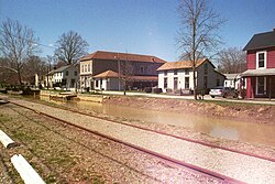
The Whitewater Canal only carried boats from 1839 to 1865, but the canal was maintained to supply hydraulic power until 1936. The canal was the center of industrial districts in Metamora and Brookville, 8 miles (13 km) to the east. At one time there were water-powered mills for processing cotton, grinding flour and making paper. Metamora is the location of Indiana's oldest and still operating grist mill. Metamora is also home to the only existing wooden aqueduct in the United States (the Duck Creek Aqueduct), [7] with a historical review of the canal history which fueled the southeastern Indiana economy until its displacement by the railroad. The canal is named after the nearby Whitewater River.

The Metamora Historic District and Whitewater Canal Historic District are listed on the National Register of Historic Places. [8]

Geography

Photo from Small Town Indiana photo survey. Metamora, Indiana.jpg
Photo from Small Town Indiana photo survey.

Metamora is located in the valley of the Whitewater River in southeastern Indiana. It is situated on U.S. Route 52, 37 miles (60 km) northwest of Cincinnati, Ohio, and 59 miles (95 km) southeast of Indianapolis. [9]

According to the U.S. Census Bureau, the CDP has a total area of 0.35 square miles (0.9 km2), all land. [10]

Demographics

Historical population
CensusPop.Note
2020 207
U.S. Decennial Census [11]

Notable person

Related Research Articles

<span class="mw-page-title-main">Franklin County, Indiana</span> County in Indiana, United States

Franklin County is a county on the eastern border of the U.S. state of Indiana. In the 2020 United States Census, the county population was 22,785. The county seat is the town of Brookville. Franklin County is part of the Cincinnati, OH–KY–IN Metropolitan Statistical Area. The only incorporated city in Franklin County is Batesville, which lies mostly in adjoining Ripley County.

<span class="mw-page-title-main">Fayette County, Indiana</span> County in Indiana, United States

Fayette County is one of 92 counties in U.S. state of Indiana located in the east central portion of the state. As of 2020, the population was 23,398. Most of the county is rural; land use is farms, pasture and unincorporated woodland. The county seat and only incorporated town is Connersville, which holds a majority of the county's population.

<span class="mw-page-title-main">Connersville, Indiana</span> City in Indiana, United States

Connersville is a city in Fayette County, east central Indiana, United States, 66 miles (106 km) east by southeast of Indianapolis. The population was 13,481 at the 2010 census. The city is the county seat of and the largest and only incorporated town in Fayette County. The city is in the center of a large rural area of east central Indiana; the nearest significant city is Richmond, 26 miles (42 km) to the northeast by road. Connersville is home to the county's only high school. The local economy relies on manufacturing, retail, and healthcare to sustain itself. However, there has been a consistent decline in both employment and population since the 1960s, placing it among the least affluent areas in the state, as indicated by measures such as median household income and other economic indicators.

<span class="mw-page-title-main">Brookville, Indiana</span> Town in Indiana, United States

Brookville is a town in Brookville Township, Franklin County, Indiana, United States. The town is the county seat of and the largest community entirely within Franklin County. The population was 2,596 at the 2010 census.

<span class="mw-page-title-main">Franklin Township, Somerset County, New Jersey</span> Township in Somerset County, New Jersey, United States

Franklin Township is a township in Somerset County, in the U.S. state of New Jersey. It is centrally located in the Raritan Valley region, within the New York Metropolitan Area. As of the 2020 United States census, the township's population was 68,364, an increase of 6,064 (+9.7%) from the 2010 census count of 62,300, which in turn reflected an increase of 11,397 (+22.4%) from the 50,903 counted in the 2000 census. The township was the state's 19th most-populous municipality in 2020, after being ranked 22nd in 2010.

<span class="mw-page-title-main">Blackwells Mills, New Jersey</span> Populated place in Somerset County, New Jersey, US

Blackwells Mills is an unincorporated community and census-designated place (CDP) located in Franklin Township in Somerset County, in the U.S. state of New Jersey. As of the 2010 U.S. census, the CDP's population was 803.

The Whitewater Valley Railroad is a heritage railroad in southeastern Indiana between Connersville and Metamora.

The Whitewater River is a 101-mile-long (163 km) southerly flowing right tributary of the Great Miami River in southeastern Indiana and southwestern Ohio in the United States. It is formed by the confluence of two forks, the West Fork and East Fork. The name is a misnomer, as there is no true white water on the river. However, there are many rapids due to the steep gradient present - the river falls an average of six feet per mile (1.1 m/km). The gradient rendered upstream navigation impossible, and in the mid-nineteenth century resulted in the construction of the Whitewater Canal paralleling the river from north of Connersville, Indiana, to the Ohio River.

Six Mile Run is an unincorporated community and census-designated place (CDP) located in Franklin Township, in Somerset County, in the U.S. state of New Jersey. As of the 2010 United States Census, the CDP's population was 3,184.

<span class="mw-page-title-main">Griggstown, New Jersey</span> Populated place in Somerset County, New Jersey, US

Griggstown is an unincorporated community and census-designated place (CDP) located within Franklin Township, in Somerset County, in the U.S. state of New Jersey. As of the 2010 United States Census, the CDP's population was 819. The area was first settled around 1733. The Millstone River and the Delaware and Raritan Canal both flow through Griggstown.

<span class="mw-page-title-main">East Millstone, New Jersey</span> Populated place in Somerset County, New Jersey, US

East Millstone is an unincorporated community and census-designated place (CDP) located in Franklin Township in Somerset County, in the U.S. state of New Jersey.

<span class="mw-page-title-main">Whitewater Canal</span> United States historic place

The Whitewater Canal, which was built between 1836 and 1847, spanned a distance of 76 miles (122 km) and stretched from Lawrenceburg, Indiana on the Ohio River to Hagerstown, Indiana near the West Fork of the White River.

<span class="mw-page-title-main">Metamora Township, Franklin County, Indiana</span> Township in Indiana, United States

Metamora Township is one of thirteen townships in Franklin County, Indiana. As of the 2010 census, its population was 974.

<span class="mw-page-title-main">New Trenton, Indiana</span> Census-designated place in Indiana, United States

New Trenton is an unincorporated community and census-designated place (CDP) in Whitewater Township, Franklin County, Indiana. As of the 2010 census it had a population of 252. It has a ZIP code 47035.

<span class="mw-page-title-main">Port Murray, New Jersey</span> Census-designated place in Warren County, New Jersey, United States

Port Murray is an unincorporated community and census-designated place (CDP) located within Mansfield Township in Warren County, in the U.S. state of New Jersey, that was created as part of the 2010 United States Census. As of the 2010 Census, the CDP's population was 129.

<span class="mw-page-title-main">Belleview, Kentucky</span> Unincorporated community in Kentucky, United States

Belleview is an unincorporated community and census-designated place (CDP) in Boone County, Kentucky, United States. The population was 308 as of the 2020 Census, down from 343 from the 2010 census.

<span class="mw-page-title-main">Deerfield (CDP), Massachusetts</span> Census-designated place in Massachusetts, United States

Deerfield is a census-designated place (CDP) in the town of Deerfield in Franklin County, Massachusetts, United States. The population was 643 at the 2010 census. It corresponds roughly to the area of Historic Deerfield, a historic district comprising the original town center of Deerfield. It is the home of Deerfield Academy, a college-preparatory school.

<span class="mw-page-title-main">Lake Santee, Indiana</span> Census-designated place in Indiana, United States

Lake Santee is an unincorporated town and census-designated place in Decatur and Franklin counties, Indiana, United States. As of the 2010 census, it had a population of 820.

<span class="mw-page-title-main">Salt Creek Commons, Indiana</span> Census-designated place in Indiana, United States

Salt Creek Commons is a census-designated place (CDP) in Union Township, Porter County, in the U.S. state of Indiana. The population was 2,117 at the 2010 census.

<span class="mw-page-title-main">Duck Creek Aqueduct</span> United States historic place

Duck Creek Aqueduct, also known as the Metamora Aqueduct and Whitewater Canal Aqueduct, is a historic aqueduct carrying the Whitewater Canal over Duck Creek in Metamora Township, Franklin County, Indiana. Built in 1846, it is the only surviving covered wood aqueduct in the United States. The aqueduct was listed on the National Register of Historic Places and designated a National Historic Landmark in 2014. It is located in the Whitewater Canal Historic District and part of the Metamora Historic District.

References

  1. "2020 U.S. Gazetteer Files". United States Census Bureau. Retrieved March 16, 2022.
  2. 1 2 U.S. Geological Survey Geographic Names Information System: Metamora, Indiana
  3. "U.S. Census website". United States Census Bureau . Retrieved January 31, 2008.
  4. "Profile of General Population and Housing Characteristics: 2010 Demographic Profile Data (DP-1): Metamora CDP, Indiana". United States Census Bureau . Retrieved October 4, 2012.
  5. Reifel, August Jacob (1915). History of Franklin County, Indiana. Windmill Publications. pp.  189.
  6. "Metamora". Franklin County Historical Society. Retrieved July 23, 2015.
  7. Hunter, David (October 1, 2003). Shifra Stein's Day Trips from Cincinnati: Getaways Less Than Two Hours Away. Globe Pequot. p. 7. ISBN   9780762727490 . Retrieved April 26, 2013.
  8. "National Register Information System". National Register of Historic Places . National Park Service. July 9, 2010.
  9. "Distance between Metamora, IN, and Indianapolis, IN" . Retrieved November 12, 2022.
  10. "Geographic Identifiers: 2010 Demographic Profile Data (DP-1): Metamora CDP, Indiana". United States Census Bureau . Retrieved October 4, 2012.
  11. "Census of Population and Housing". Census.gov. Retrieved June 4, 2016.