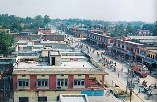
Dhangadhi is a sub-metropolitan city and the district headquarters of Kailali District in Sudurpashchim Pradesh of Nepal. It shares a border with Uttar Pradesh, India in the south, Godawari and Gauriganga Municipality in the North, Kailari Rural Municipality in the east and Kanchanpur District in the west. Dhangadhi is a sub-metropolis divided into 19 wards. It has a population of about 147,181 and thus is the 10th biggest city of Nepal. It has an area of 261.75 km2. It is one of the major cities of far-western region of Nepal along with Bhimdatta.

Achham District, a part of Sudurpashchim Pradesh, is one of the seventy-seven districts of Nepal. The district, with Mangalsen as its district headquarters, covers an area of 1,692 km2 and has a population (2011) of 257,477. It is one of the remotest districts of Nepal. It is accessible by automobile from Kathmandu and Nepalgunj via a paved road that runs along the western border of Nepal from Dhangadhi. The unpaved of Mid-Hill Highway through Dailakh district also takes to Mangalsen by crossing Karnali at Rakam.

Bardiya District, one of the seventy-seven Districts of Nepal, is part of Province No. 5 of Nepal. The district, with Gulariya as its headquarters, covers an area of 2,025 km2 (782 sq mi) and according to the 2001 census the population was 382,649 in 2011 it has 426,576.
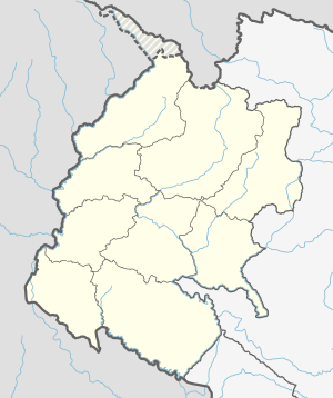
Kailali District, a part of Sudurpashchim Pradesh in Terai plain, is one of the 77 districts of Nepal. The district, with Dhangadhi as its district headquarters, covers an area of 3,235 square kilometres (1,249 sq mi) and has a population of 775,709.

Surkhet District a part of Karnali province, is one of the ten districts of Karnali located about 600 kilometres (373 mi) west of the national capital Kathmandu. The district's area is 2,488.64 square kilometres (960.87 sq mi)which is longest in Nepal. It had 288,527 population in 2001 and 350,804 in 2011 which male comprised 169,461 and female 181,381. It is the district headquarters of surkhet and commercial hub of the Karnali state of the new federal republic.

Hetauda is a sub-metropolitan city in the Makwanpur District of Bagmati Pradesh in central Nepal. It is the administrative headquarters of the Makwanpur District and the Capital of Bagmati Pradesh as declared by majority Provincal Assembly Members on 12th January, 2020. It is one of the largest cities of Nepal. At the time of the 2015 Nepal census, it had a population of 153,875 people.

Triyuga is an urban municipality out of 4 urban municipalities located in the Udayapur district of the Province No. 1 of Nepal. Gaighat is the headquarter of the municipality. According to the 1991 Nepal census, it had a population of 55,291. According to the 2011 Nepal census, Triyuga had 87,557 inhabitants. It is divided into 16 wards. Triyuga Municipality was established on B.S. Chaitra 13, 2053. It was named after Triyuga River. A river which flows through the town. Triyuga is the 3rd largest municipality in Nepal and 1st largest in Province No. 1 in term of size (area). The total area of the municipality is 547.43 square kilometres (211.36 sq mi)
Chuha is a town in Lamki Chuha Municipality in Kailali District in the Seti Zone of western Nepal. The formerly Village development committee was merged along with Baliya VDC to form the new municipality on 18 May 2014. At the time of the 1991 Nepal census it had a population of 10,145 living in 1,497 individual households.

Godawari is a municipality and capital city of Sudurpaschim province located in Kailali District of Nepal.
Joshipur is Rural Municipality in Kailali District of Sudurpashchim Pradesh established by merging Bauniya and Joshipur two existing village development committees. Joshipur lies 75 km east of Dhangadhi and 61 3 km west of the capital, Kathmandu. It is surrounded by Lamki Chuha Municipality, Tikapur Municipality and Janaki Rural Municipality in the East, Ghodaghodi Municipality and Bhajani Municipality in the West, Bardagoriya Rural Municipality in the North and Bhajani Municipality in the South.
Lamki is a small town in the eastern area of Kailali District, Nepal. It is a fairly new settlement. The demographics consists of mostly Chhetris/Brahmins, and ethnic Tharus as well. It is a small town 13 kilometers west from Karnali of Nepal. Lamki now lies in Lamki Chuha Municipality Ward Number 1. It is one of the biggest town in Kailali District.

Karnali Bridge, the asymmetric, single-tower, cable-stayed bridge is the second longest of its type in Nepal and was built by international collaboration. The bridge spans the Karnali River between the Kailali District and Bardiya District of western Nepal. The bridge was constructed by Kawasaki Heavy Industries of Japan and inaugurated after six years of its construction date by the late Prime Minister Girija Prasad Koirala.
Bardaghat [नेपाली: बर्दघाट] is a Municipality in Parasi District in Province No. 5, Nepal. It is situated in the lap of Chure range. This municipality was established on 18 May 2014 by merging existing Makar and Panchanagar VDCs. Again during the local election, the neighbouring VDC Dawanne devi and some part of Dhurkot,Jamuniya,Rupauliya were merged in it. It has a population of 55,382 with the area of 162.05 km2. It is an emerging town of Parasi District that is developing rapidly.
Gaindakot is a municipality in Nawalpur District in the Lumbini Zone of southern Nepal. It became a municipality in May 2014 by merging the existing Mukundapur, Amarapuri, and Gaindakot VDCs. It was again expanded by merging Ratanpur VDC. It is situated on the shore of Narayani River in the lap of Maula Kalika temple.So this place have a great possibility of tourism development. At the time of the 2011 Nepal census, it had a population of 58,841 and 13,623 individual households according to 2011 Nepal census.

Sudurpashchim Pradesh is one of the seven provinces established by the new constitution of Nepal which was adopted on 20 September 2015. It borders the Tibet Autonomous Region of China to the north, Karnali Pradesh and Province No. 5 to the east, and the Indian states of Uttarakhand to the west and Uttar Pradesh to the south. Initially known as Province No. 7, the newly elected Provincial Assembly adopted Sudurpashchim Pradesh as the permanent name for the province in September 2018. As per a 28 September 2018 Assembly voting, the city of Godawari has been declared the capital of the Province. The province is coterminous with the former Far-Western Development Region, Nepal.
Bardagoriya is a rural municipality in Kailali District of Nepal. Bardagoriya Rural Municipality lies 65 km east of Dhangadhi and 605 km west of the capital, Kathmandu. It is surrounded by Ghodaghodi Municipality to the west, Lamki Chuha Municipality to the east, Joshipur Rural Municipality to the south and Mohanyal to the north. Bauniya Bazar is its largest market.
Janaki is a rural municipality in Kailali District, Nepal.. Janaki lies 89 km east of Dhangadhi and 604 km west of the capital, Kathmandu. It is surrounded by Joshipur Rural Municipality in the west, Bardiya District in the east, Lamki Chuha Municipality in the north and Tikapur in the south.
Ghodaghodi Municipality is a Municipality in Kailali District of Sudurpashchim Pradesh. Ghodaghodi lies 58 km east of Dhangadhi and 613 km west of the capital, Kathmandu. It is surrounded by Mohanyal in the North, Bhajani Municipality in the south, Bardagoriya Rural Municipality in the east & Gauriganga Municipality in the west. It is DIvided into 12 wards. It was established by merging Darakh, Sadepani, Ramsikhar Jhala and Pahalmanpur 4 existing Village development committee (Nepal).
Kailari is a rural Municipality in Kailali District in Sudurpashchim Pradesh of Nepal. It is surrounded by Bajani Municipality In the East, Dhangadhi Sub Metropolitan City in the West, Gauriganga Municipality and Ghodaghodi Municipality in the North and Uttar Pradesh, India in the South.