Lane Peak

Last updated

Lane Peak
Lane Peak.jpg
Highest point
Elevation 6,012 ft (1,832 m) [1]
Prominence 332 ft (101 m) [1]
Isolation 0.71 mi (1.14 km) [2]
Coordinates 46°45′29″N121°45′11″W / 46.757953°N 121.752981°W / 46.757953; -121.752981
Naming
Etymology Franklin Knight Lane
Geography
USA Washington relief location map.jpg
Red triangle with thick white border.svg
Lane Peak
Location in Washington
Usa edcp relief location map.png
Red triangle with thick white border.svg
Lane Peak
Location in the United States
CountryUnited States
State Washington
County Lewis
Protected area Mount Rainier National Park
Parent range Cascades
Topo map USGS Mount Rainier West
Climbing
Easiest route Scrambling class 4

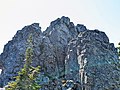
Lane Peak is a 6,012-foot (1,832-metre) mountain summit in Lewis County of Washington state. It is situated on the crest of the Tatoosh Range which is a sub-range of the Cascade Range. [1] It is located south of Mount Rainier within Mount Rainier National Park.

Contents

Lane Peak's toponym honors United States Secretary of the Interior Franklin Knight Lane, [3] who presided over the establishment of the National Park Service in 1917. Precipitation runoff on the south side of the peak drains into tributaries of the Cowlitz River, whereas the north side drains into tributaries of the Nisqually River.

Climate

Lane Peak is located in the marine west coast climate zone of western North America. [4] Most weather fronts originating in the Pacific Ocean travel northeast toward the Cascade Mountains. As fronts approach, they are forced upward by the peaks of the Cascade Range (orographic lift), causing them to drop their moisture in the form of rain or snow onto the Cascades. As a result, the west side of the Cascades experiences high precipitation, especially during the winter months in the form of snowfall. [4] Because of maritime influence, snow tends to be wet and heavy, resulting in avalanche danger. [4] During winter months, weather is usually cloudy, but due to high pressure systems over the Pacific Ocean that intensify during summer months, there is often little or no cloud cover during the summer. [4] Due to its temperate climate and proximity to the Pacific Ocean, areas west of the Cascade Crest very rarely experience temperatures below 0 °F (−18 °C) or above 80 °F (27 °C). [4]

Climbing Routes

Climbing Routes on Lane Peak [5]

See also

References

  1. 1 2 3 "Lane Peak, Washington". Peakbagger.com.
  2. "Lane Peak WA - 6,012'". Lists of John. Retrieved February 14, 2021.
  3. "GNIS Detail - Lane Peak". geonames.usgs.gov.
  4. 1 2 3 4 5 Beckey, Fred W. Cascade Alpine Guide, Climbing and High Routes. Seattle, WA: Mountaineers Books, 2008.
  5. Lane Peak Mountain Project