Related Research Articles

The Lackawanna River is a 42-mile-long (68 km) tributary of the Susquehanna River in northeastern Pennsylvania in the United States. It flows through a region of the northern Pocono Mountains that was once a center of anthracite coal mining in the United States. It starts in north Wayne County, Pennsylvania and ends in east Luzerne County, Pennsylvania in Duryea, Pennsylvania. The lower reaches of the river flow through the urban areas of Scranton, which grew around its banks in the 19th century as an industrial center. Its name comes from a Lenni Lenape word meaning "stream that forks".

Huntsville Creek is a tributary of Toby Creek in Luzerne County, Pennsylvania, in the United States. It is approximately 7.5 miles (12.1 km) long and flows through Dallas Township, Dallas, Lehman Township, Jackson Township, and Kingston Township. The watershed of the creek has an area of 14.7 square miles (38 km2). It is designated as a Coldwater Fishery and a Migratory Fishery. Wisconsinan Till, Wisconsinan Ice-Contact Stratified Drift, alluvium, sandstone and shale pits, and bedrock consisting of sandstone and shale all occur in the watershed. A 2-billion gallon reservoir known as the Huntsville Reservoir is situated on the creek. The reservoir supplies water to 30,000 people. The creek has one named tributary, which is known as Browns Creek.
Collins Creek is a tributary of Mill Creek in Luzerne County, Pennsylvania, in the United States. It is approximately 2.8 miles (4.5 km) long and flows through Pittston Township and Dupont. The watershed of the creek has an area of 1.39 square miles (3.6 km2). The creek has no named tributaries, but several drainage ditches flow into it. It is a Coldwater Fishery and is not impaired. The creek is one source of flooding in Pittston Township.

Spring Brook is a tributary of the Lackawanna River in Lackawanna County and Luzerne County, in Pennsylvania, in the United States. It is approximately 17 miles (27 km) long and flows through Covington Township, Spring Brook Township, and Moosic in Lackawanna County and Pittston Township in Luzerne County. The watershed of the stream has an area of 57.2 square miles (148 km2). It is designated as a High-Quality Coldwater Fishery and a Migratory Fishery above Interstate 476 and as a Coldwater Fishery and a Migratory Fishery below it. A section is also designated as Class A Wild Trout Waters. The stream's tributaries include Panther Creek, Plank Bridge Creek, Rattlesnake Creek, Green Run, Monument Creek, and Covey Swamp Creek. It has a relatively high level of water quality and is very slightly acidic, with a pH of 6.4 to 6.9.
Stafford Meadow Brook is a tributary of the Lackawanna River in Lackawanna County, Pennsylvania, in the United States. It is approximately 11.2 miles (18.0 km) long and flows through Roaring Brook Township, Scranton, and Moosic. The watershed of the stream has an area of 14.1 square miles (37 km2). Part of it is designated as a High-Quality Coldwater Fishery and a Migratory Fishery. The other part is a Warmwater Fishery and a Migratory Fishery. The stream has one named tributary, which is known as Mountain Lake Run. Stafford Meadow Brook has a very high level of water quality for much of its length and part of it meets the criteria for an Exceptional Value designation. The stream begins on the Pocono Plateau and flows through the Moosic Mountains in a mountainous watershed. Its channel has been substantially altered in its lower reaches.
Keyser Creek is a tributary of the Lackawanna River in Lackawanna County, Pennsylvania, in the United States. It is approximately 6.1 miles (9.8 km) long and flows through Newton Township, Ransom Township, Scranton, and Taylor. The watershed of the creek has an area of 8.59 square miles (22.2 km2). It is designated as a Coldwater Fishery and a Migratory Fishery. The creek has two named tributaries: Lucky Run and Lindy Creek.
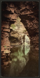
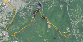
Roaring Brook is a tributary of the Lackawanna River in Lackawanna County, Pennsylvania, in the United States. It is approximately 21 miles (34 km) long and flows through Covington Township, Madison Township, Moscow, Roaring Brook Township, Elmhurst Township, Dunmore, and Scranton. The watershed of the stream has an area of 56.3 square miles (146 km2). Its named tributaries include Little Roaring Brook, Rock Bottom Creek, White Oak Run, Van Brunt Creek, Bear Brook, and East Branch Roaring Brook. It has a high level of water quality for much of its length. However, it is affected by abandoned mining land, stormwater, and other impacts in its lower reaches. Reservoirs in the watershed include the Hollister Reservoir, the Elmhurst Reservoir, and others. The stream also flows through the Nay Aug Gorge and passes over the Nay Aug Falls, which are on the National Register of Geologic Landmarks. It flows through a concrete channel in its lower reaches. The topography of the watershed contains rolling hills in its upper reaches and the mountainous land of the Moosic Mountains in its lower reaches.
Little Roaring Brook is a tributary of Roaring Brook in Lackawanna County, Pennsylvania, in the United States. It is approximately 3.4 miles (5.5 km) long and flows through Olyphant, Throop, and Dunmore. The watershed of the stream has an area of 3.06 square miles (7.9 km2). It contains several watersheds: Dunmore Reservoir Number One, Marshwood Reservoir, and Dunmore Reservoir Number Three. Some strip mining has been done in the stream's vicinity and it has a high load of sediment. The surficial geology in the stream's vicinity consists of Wisconsinan Till, surface mining land, bedrock, urban land, and wetlands.

Meadow Brook is a tributary of the Lackawanna River in Lackawanna County, Pennsylvania, in the United States. It is approximately 2.0 miles (3.2 km) long and flows through Dunmore and Scranton. The watershed of the stream has an area of 2.43 square miles (6.3 km2), though it used to be considerably larger. It is designated as a Coldwater Fishery and a Migratory Fishery, but many reaches of the stream have been destroyed by mining or post-mining development impacts. The stream flows through a culvert system for much of its length. However, there are areas where it is in an open concrete channel or has a natural streambed. There are also patches of old-growth forest along the stream in the Forest Hill Cemetery.

Leggetts Creek is a tributary of the Lackawanna River in Lackawanna County, Pennsylvania, in the United States. It is approximately 9.0 miles (14.5 km) long and flows through Scott Township, South Abington Township, and Scranton. The watershed of the creek has an area of 18.5 square miles (48 km2). The creek has three named tributaries: Leach Creek, Clover Hill Creek, and Summit Lake Creek. Leggetts Creek is considered to be impaired due to urban development problems, but is not affected by acid mine drainage. The creek is fairly alkaline and is a perennial stream. Its headwaters are in wetlands outside of the Lackawanna Valley and it flows through a water gap known as Leggetts Gap or The Notch. Major lakes in the watershed include the Griffin Reservoir, Summit Lake, and Maple Lake. The creek is a source of flooding in South Abington Township.
Leach Creek is a tributary of Leggetts Creek in Lackawanna County, Pennsylvania, in the United States. It is approximately 1.9 miles (3.1 km) long and flows through Scranton. The watershed of the creek has an area of 2.55 square miles (6.6 km2). The creek loses substantial amounts of water to underground mine pools. The creek is in the Coal Region and has been channelized and/or culvertized in some reaches. It flows alongside Pennsylvania Route 307 for a substantial part of its length. The creek has a riparian buffer in its upper and middle reaches, but various invasive plants grow along its banks in its lower reaches.
Hull Creek is a tributary of the Lackawanna River in Lackawanna County, Pennsylvania, in the United States. It is approximately 4.1 miles (6.6 km) long and flows through Scott Township, Blakely, and Dickson City. The watershed of the creek has an area of 3.22 square miles (8.3 km2). The creek is considered to be impaired by habitat alteration. It is a perennial stream, but experiences some flow loss. A waterfall system known as the Blakely Falls are on the creek, in a post-glacial valley. It also flows through a deep water gap. Channelization work was done on the creek in 1975 by the Pennsylvania Department of Environmental Resources, which has had the effect of reducing flooding.
Wildcat Creek is a tributary of the Lackawanna River in Lackawanna County, Pennsylvania, in the United States. It is approximately 3.8 miles (6.1 km) long and flows through Archbald and Blakely. The watershed of the creek has an area of 4.49 square miles (11.6 km2). It has one named tributary, which is known as West Branch Tinklepaugh Creek. The creek may lose flow to coal measures and may receive only intermittent flow even at its source. Only the upper reaches of the creek have a natural channel. It flows through an open box culvert in its lower reaches.
Sterry Creek is a tributary of the Lackawanna River in Lackawanna County, Pennsylvania, in the United States. It is approximately 4.7 miles (7.6 km) long and flows through Jessup and Olyphant. The watershed of the creek has an area of 4.92 square miles (12.7 km2). The creek is impaired by flow and habitat alterations along with flow loss. The O'Conner Dam is on Sterry Creek and impounds a six-acre reservoir. The creek is a major source of flooding in the borough of Jessup. It is designated as a Coldwater Fishery and a Migratory Fishery.
Grassy Island Creek is a tributary of the Lackawanna River in Lackawanna County, Pennsylvania, in the United States. It is approximately 4.4 miles (7.1 km) long and flows through Jefferson Township and Jessup. The watershed of the creek has an area of 5.42 square miles (14.0 km2). The lower reaches of the creek are impaired, but the upper reaches are not impaired. It is an intermittent stream during the summer, but its flow has been recorded as being as high as 116,553.21 gallons per minute. Some manganese, acidity, and alkalinity are also in the creek. It is in the Appalachian Mountain section of the ridge and valley physiographic province. The main rock formations in the creek's watershed are made of sandstone and interbedded sedimentary rocks. Some reservoirs are in the watershed at the boundary between the Pocono Formation and the Llewellyn Formation.
White Oak Run is a tributary of the Lackawanna River in Lackawanna County, Pennsylvania, in the United States. It is approximately 3.4 miles (5.5 km) long and flows through Jefferson Township and Archbald. The watershed of the stream has an area of 5.11 square miles (13.2 km2). The stream is impacted by various types of debris, localized iron hydroxide deposits, stormwater, and combined sewer overflows. However, its middle and upper reaches are largely undisturbed. The White Oak Ravines are in the stream's watershed.
Aylesworth Creek is a tributary of the Lackawanna River in Lackawanna County, Pennsylvania, in the United States. It is approximately 4.9 miles (7.9 km) long and flows through Carbondale Township and the boroughs of Mayfield and Archbald. The watershed of the creek has an area of 6.73 square miles (17.4 km2). Part of the creek is impaired by abandoned mine drainage and/or resource extraction. The creek tends to be slightly acidic, but its iron, manganese, and aluminum concentrations do not need reduction to meet its total maximum daily load requirements. Its watershed is in the Appalachian Mountain section of the ridge and valley physiographic province. The headwaters of the creek are in the Moosic Mountains. The rock formations in the watershed mainly consist of interbedded sedimentary rock and sandstone.
Rush Brook is a tributary of the Lackawanna River in Lackawanna County, Pennsylvania, in the United States. It is approximately 5.1 miles (8.2 km) long and flows through Greenfield Township, Scott Township, Carbondale Township, Mayfield, and Jermyn. The watershed of the stream has an area of 6.01 square miles (15.6 km2). The stream is not considered to be impaired and all but its lower reaches are mostly undisturbed. However, Pennsylvania Route 107 is in its vicinity. The stream begins on the Allegheny Plateau and flows through a water gap. It is a perennial stream.
Fall Brook is a tributary of the Lackawanna River in Susquehanna County and Lackawanna County, Pennsylvania, in the United States. It is approximately 7.9 miles (12.7 km) long and flows through Clifford Township in Susquehanna County and Fell Township, Carbondale Township, and Carbondale in Lackawanna County. The watershed of the stream has an area of 12.4 square miles (32 km2), making it one of the largest tributaries of the Lackwanna River. It is not designated as impaired, but does experience flow loss. The stream begins on the Allegheny Plateau and passes through the Fall Brook Gap. It also flows over the Fall Brook Falls, which are 60 feet (18 m) high. Fall Brook is situated within the Coal Region.
Racket Brook is a tributary of the Lackawanna River in Wayne County and Lackawanna County, in Pennsylvania, in the United States. It is approximately 3.6 miles (5.8 km) long and flows through Canaan Township in Wayne County and Carbondale Township and Carbondale in Lackawanna County. The watershed of the stream has an area of 5.29 square miles (13.7 km2). The stream has no named tributaries, but has two unnamed tributaries. It is not designated as impaired, but it does experience minor flow loss. It drains part of the Moosic Mountains and also flows through a ravine known as the Brownell Ravine.
References
- 1 2 3 4 Federal Emergency Management Agency (July 27, 2011), Flood Insurance Study Volume 1 of 3 (PDF), pp. 17, 20, 25, 43, archived from the original (PDF) on April 18, 2015, retrieved May 15, 2015
- 1 2 3 4 United States Geological Survey, The National Map Viewer, archived from the original on April 5, 2012, retrieved May 12, 2015
- 1 2 Pennsylvania Gazetteer of Streams (PDF), November 2, 2001, p. 83, retrieved May 12, 2015
- 1 2 3 4 5 6 7 8 9 10 11 12 13 Lackawanna River Corridor Association (2001), Lackawanna River Watershed Conservation Plan (PDF), pp. 63–66, 119–120, 136–137, 207–208, 240, 313–314, retrieved May 15, 2015
- ↑ "V. Applications for NPDES Waiver Stormwater Discharges from MS4", Pennsylvania Bulletin , retrieved May 15, 2015
- ↑ Pennsylvania Water Supply Commission (1916), Water Resources Inventory Report ...: Act of July 25, 1913, Part 10, p. 26, retrieved May 15, 2015
- 1 2 3 Geographic Names Information System, Feature Detail Report for: Laurel Run , retrieved May 12, 2015
- 1 2 Engineering News-record, Volume 11, 1884, p. 93, retrieved May 15, 2015
- ↑ Pennsylvania Department of Health (1917), Report, Part 2, p. 1285, retrieved May 15, 2015
- ↑ "§ 93.9j. Drainage List J. Susquehanna River Basin in Pennsylvania Lackawanna River", Pennsylvania Code , retrieved May 12, 2015
- ↑ Pennsylvania Fish and Boat Commission (January 2015), Pennsylvania Wild Trout Waters (Natural Reproduction) - Jan 2015 (PDF), p. 45, retrieved May 12, 2015