Lavelle-Locustdale, Pennsylvania

Last updated
Lavelle-Locustdale
Former CDP
USA Pennsylvania location map.svg
Red pog.svg
Lavelle-Locustdale
Location within the U.S. state of Pennsylvania
Coordinates: 40°45′50″N76°22′50″W / 40.76389°N 76.38056°W / 40.76389; -76.38056
Country United States
State Pennsylvania
County Schuylkill
Area
  Total1.0 sq mi (2.7 km2)
  Land1.0 sq mi (2.7 km2)
Population
 (2000)
  Total649
  Density620/sq mi (240/km2)
Time zone UTC-5 (Eastern (EST))
  Summer (DST) UTC-4 (EDT)

Lavelle-Locustdale was a census-designated place (CDP) in Schuylkill County, Pennsylvania, United States. The population was 649 at the 2000 census. For the 2010 census the area was split into two CDPs, Lavelle and Locustdale.

Contents

Geography

Lavelle-Locustdale was located at 40°45′50″N76°22′50″W / 40.76389°N 76.38056°W / 40.76389; -76.38056 (40.763779, -76.380429). [1]

According to the United States Census Bureau, the CDP had a total area of 1.0 square mile (2.6 km2), all of it land.

Demographics

As of the census [2] of 2000, there were 649 people, 275 households, and 194 families residing in the CDP. The population density was 624.6 inhabitants per square mile (241.2/km2). There were 299 housing units at an average density of 287.7 per square mile (111.1/km2). The racial makeup of the CDP was 98.92% White, 0.77% Asian, 0.31% from other races.

There were 275 households, out of which 25.5% had children under the age of 18 living with them, 61.1% were married couples living together, 6.5% had a female householder with no husband present, and 29.1% were non-families. 26.2% of all households were made up of individuals, and 13.8% had someone living alone who was 65 years of age or older. The average household size was 2.36 and the average family size was 2.84.

In the CDP, the population was spread out, with 18.3% under the age of 18, 6.9% from 18 to 24, 30.2% from 25 to 44, 27.0% from 45 to 64, and 17.6% who were 65 years of age or older. The median age was 42 years. For every 100 females, there were 92.0 males. For every 100 females age 18 and over, there were 94.1 males.

The median income for a household in the CDP was $32,656, and the median income for a family was $49,659. Males had a median income of $38,750 versus $17,614 for females. The per capita income for the CDP was $27,323. None of the families and 2.0% of the population were living below the poverty line, including no under eighteens and none of those over 64.

Related Research Articles

<span class="mw-page-title-main">Rossville, Maryland</span> Census-designated place in Maryland, United States

Rossville is an unincorporated community and census-designated place in Baltimore County, Maryland, United States. The population was 15,147 at the 2010 census.

<span class="mw-page-title-main">Cloverly, Maryland</span> Census-designated place in Maryland, United States

Cloverly is an unincorporated town and census-designated place in Montgomery County, Maryland, United States. Its population was 15,285 as of the 2020 census.

<span class="mw-page-title-main">China Lake Acres, California</span> Census-designated place in California, United States

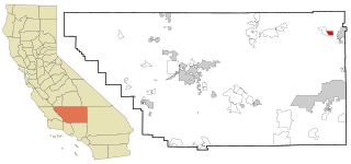
China Lake Acres is a census-designated place (CDP) in Kern County, California, United States. The population was 1,876 at the 2010 census, up from 1,761 at the 2000 census.

Locustdale is a census-designated place (CDP) that is located on the border of Columbia and Schuylkill counties, Pennsylvania, United States. It is part of Northeastern Pennsylvania.

<span class="mw-page-title-main">Fairview-Ferndale, Pennsylvania</span> CDP in Pennsylvania, United States

Fairview-Ferndale is a census-designated place (CDP), located in Coal Township, in Northumberland County, Pennsylvania, United States. The population was 2,411 at the 2000 census.

<span class="mw-page-title-main">Marshallton, Pennsylvania</span> CDP in Pennsylvania, United States

Marshallton is a census-designated place (CDP), located in Coal Township, in Northumberland County, Pennsylvania, United States. The population was 1,441 at the 2010 census.

Altamont is a census-designated place (CDP) in Schuylkill County, Pennsylvania, United States. The population was 2,689 at the 2000 census.

Branchdale is a census-designated place (CDP) in Schuylkill County, Pennsylvania, United States. The population was 436 at the 2000 census.

Forestville is a census-designated place (CDP) in Schuylkill County, Pennsylvania, United States. The population was 431 at the 2000 census.

<span class="mw-page-title-main">Klingerstown, Pennsylvania</span> CDP in Pennsylvania, United States

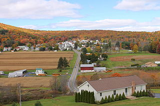
Klingerstown is a census-designated place (CDP) in Upper Mahantongo Township, Schuylkill County, Pennsylvania, United States. As of the 2000 census, the CDP population was 102.

<span class="mw-page-title-main">Lake Wynonah, Pennsylvania</span> CDP in Pennsylvania, United States

Lake Wynonah is a census-designated place (CDP) in Schuylkill County, Pennsylvania, United States. The population was 1,961 at the 2000 census, and 2,640 at the 2010 census. Lake Wynonah is a gated community with two lakes, Fawn Lake and Lake Wynonah, and as of July 2008, there are over 1200 homes and 1500 members. It is in South Manheim and Wayne Townships.

McKeansburg is a census-designated place (CDP) in Schuylkill County, Pennsylvania, United States. The population was 155 at the 2000 census.

Newtown is a census-designated place (CDP) in Reilly Township, Schuylkill County in the U.S. state of Pennsylvania. The population was 244 at the 2000 census.

<span class="mw-page-title-main">Nuremberg, Pennsylvania</span> Census-designated place in Pennsylvania, United States

Nuremberg is a census-designated place (CDP) that is located in Schuylkill and Luzerne counties, Pennsylvania, United States. The population was 434 at the time of the 2010 census.

<span class="mw-page-title-main">Shenandoah Heights, Pennsylvania</span> CDP in Pennsylvania, United States

Shenandoah Heights is a census-designated place (CDP) in Schuylkill County, Pennsylvania. The population was 1,298 at the 2000 census.

Summit Station is a census-designated place (CDP) in Schuylkill County, Pennsylvania, United States. The population is 174 as of the 2010 census.

<span class="mw-page-title-main">Emigsville, Pennsylvania</span> CDP in Pennsylvania, United States

Emigsville is a census-designated place (CDP) in York County, Pennsylvania, United States. The population was 2,672 at the 2010 census.

<span class="mw-page-title-main">Valley Green, Pennsylvania</span> CDP in Pennsylvania, United States

Valley Green is a census-designated place (CDP) in York County, Pennsylvania, United States. The population was 3,429 at the 2010 census.

<span class="mw-page-title-main">South Alamo, Texas</span> Census-designated place in Texas

South Alamo is a census-designated place (CDP) in Hidalgo County, Texas. The area is known locally as "Little Mex (Mexico)". The population was 3,361 at the 2010 United States Census. It is part of the McAllen–Edinburg–Mission Metropolitan Statistical Area.

<span class="mw-page-title-main">Baring, Washington</span> Census-designated place in Washington, United States

Baring is an unincorporated community and census-designated place (CDP) in King County, Washington, United States. The population was 220 at the 2010 United States Census. It is located on U.S. Highway 2 about 23 miles (37 km) west of Stevens Pass, along a very flat and straight three-mile section of highway that has been dubbed the "Baring Straight", since US-2 is otherwise hilly and curvy through the mountains. The settlement was first known as "Salmon", but by 1909 it was known as Baring.

References

  1. "US Gazetteer files: 2010, 2000, and 1990". United States Census Bureau. 2011-02-12. Retrieved 2011-04-23.
  2. "U.S. Census website". United States Census Bureau . Retrieved 2008-01-31.