Transport in Ghana is accomplished by road, rail, air and water. Ghana's transportation and communications networks are centered in the southern regions, especially the areas in which gold, cocoa, and timber are produced. The northern and central areas are connected through a major road system.
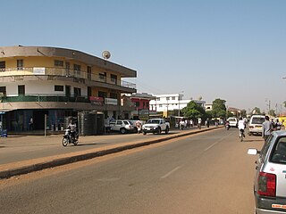
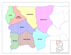
Wa is a town and is the capital of Wa Municipal District and the Upper West Region of north Ghana. Wa has a 2012 settlement population of 102,446. Features of the town include several churches and mosques, the Wa-Na Palace, the St. Andrew's Catholic cathedral, the University for Development Studies (UDS), a museum and a nearby hippopotamus sanctuary. The geography of Wa is notable for the dramatic monadnock Ombo Mountain which is located around Kaleo and visible from much of the Wa town. Other notable towns around Wa region include Naaha and Ga.

Lawra is a small town and is the capital of Lawra district, a district in the Upper West Region of Ghana.

The Upper West Region of Ghana is located in the north-western corner of Ghana and is bordered by Upper East region to the east, Northern region to the south, and Burkina Faso to the west and north. The Upper West regional capital and largest settlement is Wa. Upper West is the youngest region, created in Ghana by the then Head of State, Flight-Lieutenant Jerry Rawlings in 1983 under the Provisional National Defense Council (PNDC). The area was carved out of the former Upper Region, which is now the Upper East Region.
The Upper East Region is located in north Ghana and is the second smallest of 10 now 16 administrative regions in Ghana, occupying a total land surface of 8,842 square kilometers or 2.7 per cent of the total land area of Ghana. The Upper East regional capital is Bolgatanga, sometimes referred to as Bolga. Other major towns in the region include Navrongo, Paga, Bawku and Zebilla.

The Eastern Region is located in south Ghana and is one of the sixteen administrative regions of Ghana. Eastern region is bordered to the east by the Lake Volta, to the north by Bono East Region and Ashanti region, to the west by Ashanti region, to the south by Central region and Greater Accra Region. Akans are the dominant inhabitants and natives of Eastern region and Akan, Ewe, Krobo, Hausa and English are the main spoken languages. The capital town of Eastern Region is Koforidua.The Eastern region is the location of the Akosombo dam and the economy of the Eastern region is dominated by its high-capacity electricity generation. Eastern region covers an area of 19,323 square kilometres, which is about 8.1% of Ghana's total landform.

The Northern Region is one of the sixteen regions of Ghana. It is located in the north of the country and was the largest of the sixteen regions, covering an area of 70,384 square kilometres or 31 percent of Ghana's area until December 2018 when the Savannah Region and North East Region were created from it. The Northern Region is divided into 14 districts. The region's capital is Tamale.

The Jirapa/Lambussie District is one of the eleven districts in the Upper West Region of north Ghana. The capital is Jirapa.
West Mamprusi Municipal Assembly is one of the six districts in North East Region, Ghana. Originally created as an ordinary district assembly in 1988 when it was known as West Mamprusi District. Later, part of the district was split off on 28 June 2012 to create Mamprugu Moagduri District; thus the original remaining part was still known as West Mamprusi District. Then, it was upgraded to municipal district assembly status on 15 March 2018 to become West Mamprusi Municipal District. The municipality is located in the western part of North East Region and has Walewale as its capital town. Other settlements within the municipal assembly include Wulugu.

Yilo Krobo Municipal District is one of the thirty-three districts in Eastern Region, Ghana. Originally created as an ordinary district assembly in 1988 when it was known as Yilo Krobo District, after it was created from the former Kaoga District. Later, it was elevated to municipal district assembly status on 6 February 2012. The municipality is located in the eastern part of Eastern Region and has Somanya as its capital town.

Sissala West is one of the constituencies represented in the Parliament of Ghana. It elects one Member of Parliament (MP) by the first past the post system of election. Sissala West is located in the Sissala West district of the Upper West Region of Ghana.
Lambussie is one of the constituencies represented in the Parliament of Ghana. It elects one Member of Parliament (MP) by the first past the post system of election. Lambussie is located in the Jirapa/Lambussie district of the Upper West Region of Ghana.
Lawra-Nandom is one of the constituencies represented in the Parliament of Ghana. It elects one Member of Parliament (MP) by the first past the post system of election. Lawra-Nandom is located in the Lawra district of the Upper West Region of Ghana.
Benjamin Bewa-Nyog Kumbuor was the Ghanaian Minister for Defence of the Ghanaian Ministry of Defence and a Ghanaian politician. He is the Member of Parliament for the Nandom constituency.
The Jirapa District is a district of Ghana in the Upper West Region of Ghana. The total area of the district is 1,667 square kilometers. This constitutes about 9% of the Region's area of 18,476 square kilometers. The Capital of the District is Jirapa. The district shares boundaries to the South with Nadowli District, to the East with Sissala District, to the West with Lawra District and to the North with Lambussie Karni.
The Lambussie Karni District is one of the eleven districts in the Upper West Region of north Ghana. The capital is Lambussie. The district was created in 2008, and was inaugurated on 29 February 2008.
Lambussie is a small town and is the capital of Lambussie Karni district, a district in the Upper West Region of north Ghana.
Zambo, one of eight divisional group under the Lawra Traditional council, is a small town in the upper west region of Ghana. It is about 87.5 kilometres (54.4 mi) north of Wa, Ghana the regional capital. Found under the Lawra Municipal, it and nearby Eremon both claim to be the biggest village in the entire municipal. The people are mainly Dagaabas and they speak an indigenous language called Dagaare. The religion there is mainly Roman Catholicism and the traditional religion which has been there for ages.
Alice Teni Boon is a Ghanaian politician who served as the member of parliament for the Lambussie constituency from 1999 to 2009.
The N12 or National Highway 12 is a national highway in Ghana that begins at the Ghana - Côte d'Ivoire border in the Western Region of Ghana and travels generally north to Hamile on the Ghana - Burkina Faso border. Its total length is 670 kilometres.