
Beeston is a village and civil parish in the unitary authority of Cheshire West and Chester, which itself is in the ceremonial county of Cheshire in the north of England. It is located approximately 10 km south-east of Chester, and approximately 3.5 km south-west of Tarporley, close to the Shropshire Union Canal. According to the 2011 census, Beeston had a population of 188.

Northwich is a market and port town and civil parish in the unitary authority of Cheshire West and Chester in the ceremonial county of Cheshire, England. It lies in the heart of the Cheshire Plain, at the confluence of the rivers Weaver and Dane. The town is about 18 miles (29 km) east of Chester, 15 miles (24 km) south of Warrington, and 19 miles (31 km) south of Manchester.

A civil parish is a country subdivision, forming the lowest unit of local government in England. There are 333 civil parishes in the ceremonial county of Cheshire, most of the county being parished. Cheshire East unitary authority is entirely parished. At the 2001 census, there were 565,259 people living in 332 parishes, accounting for 57.5 per cent of the county's population.
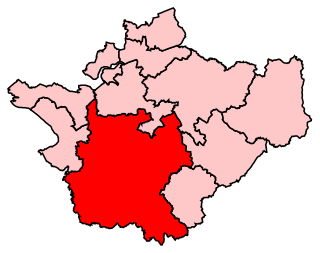
Eddisbury is a constituency in Cheshire represented in the House of Commons of the UK Parliament since 2019 by Edward Timpson, a Conservative.

Weaver Vale is a constituency in Cheshire represented in the House of Commons of the UK Parliament since 2017 by Mike Amesbury, a member of the Labour Party.

Winnington is a small, mainly residential area of the town of Northwich, in the Cheshire West and Chester district, in the ceremonial county of Cheshire, England.

Over is an ancient borough, mentioned in the Domesday Book, now a part of Winsford in the Cheshire West and Chester district, in the ceremonial county of Cheshire, England. Wharton forms the eastern part, the boundary being the River Weaver. It is said to have retained its borough status and to be the smallest borough in England.

Tarporley is a large village and civil parish in Cheshire, England. The civil parish also contains the village of Rhuddall Heath. Tarporley is bypassed by the A49 and A51 roads.

Davenham is a village and civil parish in Cheshire, England. It is part of the Borough of Cheshire West and Chester. It had a population of 2,745 at the 2011 census. It is in the centre of the Cheshire Plain near both the River Dane and River Weaver.

Whitley is a civil parish in the unitary authority of Cheshire West and Chester and the ceremonial county of Cheshire, England. It is surrounded by the parishes of Antrobus, Comberbach, Little Leigh and Dutton. It also borders Daresbury in Halton borough as well as Hatton and Stretton in Warrington borough. It is a small village located next to Antrobus.

Eaton is a small village and former civil parish in the Cheshire West and Chester district, in the ceremonial county of Cheshire, England, about two miles from the town of Tarporley. It is now in the parish of Rushton. In 1931 the parish had a population of 353.

Hartford is a village and civil parish in the unitary authority of Cheshire West and Chester and the ceremonial county of Cheshire, England. It lies at the intersection of the A559 road and the West Coast Main Line and is less than 2 miles (3.2 km) south west of the town of Northwich. It forms part of the Weaver Vale parliamentary constituency. According to the 2011 Census, the population of the parish was 5,558.

Wheelock is a large village in the civil parish of Sandbach which is in the unitary authority of Cheshire East and the ceremonial county of Cheshire, England. It is south of Sandbach on the road to Crewe. It was named after the River Wheelock.
Oakmere is a village and former civil parish, now in the parish of Delamere and Oakmere, in the Cheshire West and Chester district, in the county of Cheshire, England. The population of the civil parish taken at the 2011 census was 589. Oakmere was formerly a township in the parish of Delamere, in 1866 Oakmere became a civil parish, on 1 April 2015 the parish was abolished and merged with Delamere to form "Delamere and Oakmere", part also went to Cuddington.
Stanthorne is a village and former civil parish, now in the parish of Stanthorne and Wimboldsley, in the Cheshire West and Chester district, in the ceremonial county of Cheshire, England, 2 miles west of Middlewich. The A54 runs through the village, connecting it to the railway station at Winsford. At the 2011 census, it had a population of 153.

Wimboldsley is a village and former civil parish, now in the parish of Stanthorne and Wimboldsley, in the Cheshire West and Chester district, in the ceremonial county of Cheshire, England, 2 miles south of Middlewich. The population of the parish at the 2011 census was 153.
The history of Northwich can be traced back to the Roman period. The area around Northwich has been exploited for its salt pans since this time. The town has been severely affected by salt mining with subsidence historically being a large issue. A programme of mine stabilisation has recently been undertaken.

Northwich Rural District was a rural district surrounding, but not including the towns of Northwich and Winsford in Cheshire, which were separate urban districts. It was created in 1894 from the Northwich Rural Sanitary District.

Higher Whitley is a village and former civil parish, now in the parish of Whitley, in the unitary authority area of Cheshire West and Chester, in the ceremonial county of Cheshire, England. In 1931 the parish had a population of 339. It is north of Lower Whitley.

Kingsmead is a residential development and civil parish in the Cheshire West and Chester district, Cheshire, England, located on the eastern bank of the River Weaver. South of Northwich and west of Leftwich, the development is a greenfield site and was constructed by Redrow to hold a population of 5,000 people as a suburb of Northwich. The parish was created on 1 April 2011 from parts of Davenham and Northwich. It has a post code starting with CW9.

