A dolmen or portal tomb is a type of single-chamber megalithic tomb, usually consisting of two or more upright megaliths supporting a large flat horizontal capstone or "table". Most date from the Late Neolithic period and were sometimes covered with earth or smaller stones to form a tumulus. Small pad-stones may be wedged between the cap and supporting stones to achieve a level appearance. In many instances, the covering has eroded away, leaving only the stone "skeleton".

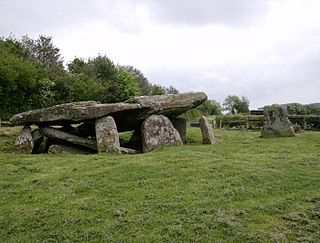
Lanyon Quoit is a dolmen in Cornwall, England, United Kingdom, 2 miles southeast of Morvah. It collapsed in a storm in 1815 and was re-erected nine years later, and as a result the dolmen is now very different from its original appearance.

The Hurlers is a group of three stone circles in the civil parish of St Cleer, Cornwall, England, UK. The site is half-a-mile (0.8 km) west of the village of Minions on the eastern flank of Bodmin Moor, and approximately four miles (6 km) north of Liskeard.
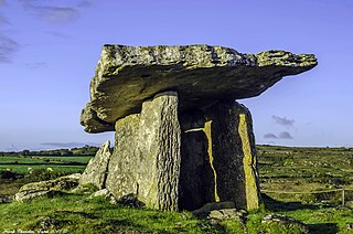
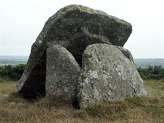
Chûn Quoit is one of the best preserved of all Neolithic quoits in western Cornwall, England, United Kingdom.

Lanlivery is a village and civil parish in Cornwall, England, United Kingdom. The village is about 1+1⁄2 miles (2.4 km) west of Lostwithiel and five miles (8 km) south of Bodmin. The Saints' Way runs past Lanlivery. Helman Tor, Red Moor and Breney Common nature reserves lie within the parish.

Pentre Ifan is the name of an ancient manor in the community and parish of Nevern, Pembrokeshire, Wales. It is 11 miles (18 km) from Cardigan, Ceredigion, and 3 miles (4.8 km) east of Newport, Pembrokeshire. Pentre Ifan contains and gives its name to the largest and best preserved neolithic dolmen in Wales.

Lanivet is a village and civil parish in Cornwall, England, United Kingdom. The village is situated approximately 2+1⁄2 miles (4.0 km) southwest of Bodmin, and before the Bodmin by-pass was built, the A30 road between London and Land's End passed through the village. The Saints' Way long-distance footpath passes Lanivet near its half-way point.
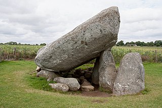
Brownshill Dolmen is a very large megalithic portal tomb situated 3 km east of Carlow, in County Carlow, Ireland. Its capstone weighs an estimated 150 metric tons, and is reputed to be the heaviest in Europe. The tomb is listed as a National Monument. Known as the Kernanstown Cromlech, sometimes spelled as Browneshill Dolmen, it is sited on the former estate house of the Browne family from which it takes its name.
Bosporthennis is a hamlet south of Treen in the civil parish of Zennor on the Penwith peninsula in west Cornwall, England, United Kingdom.
Arthur's Stone is a Neolithic chambered tomb, or dolmen, in Herefordshire, England. It is situated on the ridge line of a hill overlooking both the Golden Valley, Herefordshire and the Wye Valley. The tomb dates from 3,700 BC – 2,700 BC.

Coetan Arthur dolmen, also known as Arthur's Quoit is the remains of a Neolithic burial chamber. It dates from around 3000 BCE. The site, situated on the hillside close to St Davids Head in Pembrokeshire, Wales, is the collapsed chamber of what is presumed to be a passage grave which also has a round barrow. The massive capstone measures approximately 6 m (20 ft) by 2.5 m and is supported on one side by an orthostat approximately 1.5 m in height.

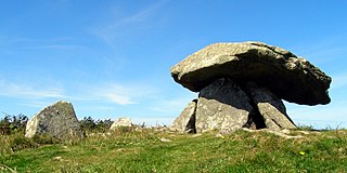
Zennor Quoit is a ruined megalithic burial chamber or dolmen, located on a moor about a mile (1.6 km) east of the village of Zennor, Cornwall, England, UK. It dates to 2500–1500 BC. Aside from the 12.5-tonne (12,500 kg) roof, which collapsed some time between 1770 and 1865, the chamber is in good condition.
Sperris Quoit is a ruined megalithic burial chamber or dolmen, and one of a type of tomb unique to West Penwith, located on a moor around 365 metres northeast of Zennor Quoit, being roughly halfway between Zennor and Amalveor, Cornwall. It is the northernmost quoit in the Penwith peninsula and a Scheduled Monument.

Nordic megalith architecture is an ancient architectural style found in Northern Europe, especially Scandinavia and North Germany, that involves large slabs of stone arranged to form a structure. It emerged in northern Europe, predominantly between 3500 and 2800 BC. It was primarily a product of the Funnelbeaker culture. Between 1964 and 1974, Ewald Schuldt in Mecklenburg-Western Pomerania excavated over 100 sites of different types: simple dolmens, extended dolmens, passage graves, great dolmens, unchambered long barrows, and stone cists. In addition, there are polygonal dolmens and types that emerged later, for example, the Grabkiste and Röse. This nomenclature, which specifically derives from the German, is not used in Scandinavia where these sites are categorised by other, more general, terms, as dolmens, passage graves and stone cists.

Helman Tor is a granite hill in mid Cornwall, UK with several separated tors, and is designated as a (non-statutory) County Geology Site. The hill also has a Scheduled Ancient Monument. Helman Tor is also the name of the largest nature reserve managed by the Cornwall Wildlife Trust which includes Breney Common and Red Moor. The Wildlife Trust aims to rewild the reserve, including potentially releasing beavers, as well as long-horn cattle and Cornish black pigs. Helman Tor, along with Breney Common, Red Moor and Belowda Beacon, is part of the Mid Cornwall Moors Site of Special Scientific Interest. It lies on the Saints' Way, a long-distance footpath completed in 1986.
Mulfra Quoit is a Neolithic dolmen in the county of Cornwall in England. It stands on Mulfra Hill to the north of the hamlet of Mulfra.

The Knockeen Portal Tomb is a megalith in Knockeen, County Waterford, Ireland. It is the largest dolmen in County Waterford exhibiting a double capstone configuration, though it is not the tallest standing stone structure. It is one of the finest examples of a dolmen in Ireland.

Pawton Quoit is a prehistoric portal dolmen, which dates to the Early and Middle Neolithic period in England. The burial monument is located near Haycrock Farm, south of St Breock, in Cornwall, England.

Wet Withens is a Bronze Age henge on Eyam Moor in the Derbyshire Peak District, England. The prehistoric circle of 10 upright stones (orthostats) is a protected Scheduled Monument.