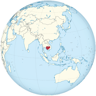
Cambodia is a country in mainland Southeast Asia, border Thailand, Laos, Vietnam, the Gulf of Thailand and covers a total area of 181,035 km2 (69,898 sq mi). The country is situated in its entirety inside the tropical Indomalayan realm and the Indochina Time zone (ICT).

The system of Transport in Cambodia, rudimentary at the best of times, was severely damaged in the chaos that engulfed the nation in the latter half of the 20th century. The country's weak transport infrastructure hindered emergency relief efforts, exacerbating the logistical issues of procurement of supplies in general and their distribution. Cambodia received Soviet technical assistance and equipment to support the maintenance of the transportation network.

The Mekong or Mekong River is a trans-boundary river in East Asia and Southeast Asia. It is the world's twelfth longest river and the third longest in Asia. Its estimated length is 4,909 km (3,050 mi), and it drains an area of 795,000 km2 (307,000 sq mi), discharging 475 km3 (114 cu mi) of water annually. From the Tibetan Plateau the river runs through China, Myanmar, Laos, Thailand, Cambodia, and Vietnam. The extreme seasonal variations in flow and the presence of rapids and waterfalls in the Mekong make navigation difficult. Even so, the river is a major trade route between western China and Southeast Asia.

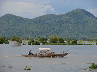
Tonlé Sap is a seasonally inundated freshwater lake, Tonlé Sap Lake, and an attached river, the 120 km (75 mi) long Tonlé Sap River, that connects the lake to the Mekong River. They form the central part of a complex hydrological system, in the 12,876 km2 (4,971 sq mi) Cambodian floodplain covered with a mosaic of natural and agricultural habitats that the Mekong replenishes with water and sediments annually. The central plain formation is the result of millions of years of Mekong alluvial deposition and discharge. From a geological perspective, the Tonlé Sap Lake and Tonlé Sap River are a current freeze-frame representation of the slowly but continuously shifting lower Mekong basin. Annual fluctuation of the Mekong's water volume, supplemented by the Asian monsoon regime, causes a unique flow reversal of the Tonlé Sap River. The largest freshwater lake in Southeast Asia, it contains an exceptionally large variety of interconnected eco-regions with a high degree of biodiversity and is therefore a biodiversity hotspot. It was designated a UNESCO biosphere reserve in 1997.
Articles related to Cambodia and Cambodian culture include:

Kampong Chhnang is one of the central provinces (khaet) of Cambodia. Neighboring provinces are Kampong Thom, Kampong Cham, Kandal, Kampong Speu and Pursat. The provincial capital is the city of Kampong Chhnang.

Kampong Thom is a province (khaet) of Cambodia. It borders the provinces of Siem Reap to the northwest, Preah Vihear to the north, Stung Treng to the northeast, Kratie to the east, Kampong Cham, Kampong Chhnang to the south, and the Tonle Sap to the west.

Pursat is a province (khaet) of Cambodia. It is in the western part of the country and borders clockwise from the north: Battambang province, the Tonlé Sap, Kampong Chhnang province, Kampong Speu province, Koh Kong province, and Thailand. It lies between the Tonle Sap and the northern end of the Cardamom Mountains. The Pursat River bisects the province, running from the Cardamoms in the west to the Tonle Sap in the east.

Cambodia is divided into 25 provinces. The capital Phnom Penh is not a province but an "autonomous municipality", equivalent to a province governmentally and administered at the same level as the other 24 provinces.
Koh Sotin is a district (srok) located in Kampong Cham province, Cambodia. The district capital is Chi Haer town located around 10 kilometres south of the provincial capital of Kampong Cham by water, but some 42 kilometres by road. The district borders on the southern bank of the Mekong River and includes the islands of Koh Sothin and Koh Mitt in its area.

Tboung Khmum is a district (srok) located in Tboung Khmum province, Cambodia. The district capital is Tboung Khmum town located around 20 kilometres east of the provincial capital of Kampong Cham by road. Tboung Khmum was formerly a central district of Kampong Cham before Tboung Khmum Province was formed from land formerly part of Kampong Cham. The district shares no borders with other provinces and is home to the huge Chup Rubber plantation. The plantation covers much of the land area of the district and contributes a large proportion to the district and provincial economy.
Baribour is a district (srok) in the north of Kampong Chhnang province, in central Cambodia. The district capital is Baribour town located around 38 kilometres north west of the provincial capital of Kampong Chhnang by road. The district shares a border with Pursat province to the west and with Kampong Thom province to the north. The district borders on the Tonle Sap and the Tonle Sap river forms the northern and eastern borders of the district.

Kampong Tralach is a district (srok) in the south east of Kampong Chhnang province, in central Cambodia. The district capital is Kampong Tralach town located 37 kilometres south of the provincial capital of Kampong Chhnang by road. The district shares a border with Kandal province to the south and Kampong Cham province to the east. The Tonle Sap river runs through the district crossing roughly from north to south.
Natural resources are materials that occur in a natural form within environments. These can be classified as either biotic or abiotic on the basis of their origin. The landmass and the territorial waters of Cambodia contain a rather moderate amount, array and variety of resources. Apart from water, abiotic resources, such as minerals are generally rare. Still, advanced geo-scientific technologies have produced remarkable results and re-assessments in recent years, such as the localization of offshore oil and gas depots in the Gulf of Thailand. Cambodia, on the other hand possesses a relatively wide range of biotic resources, in particular timber, forest products, rare plants and a fauna of great diversity.

The Tonlé Sap Biosphere Reserve is a unique ecological phenomenon surrounding the Tonlé Sap or Great Lake of Cambodia. In 1997, it was successfully nominated as a UNESCO Biosphere Reserve.

Sihanoukville Autonomous Port is a government agency and state corporation of Cambodia and Sihanoukville that operates and governs the country's sole deep water port. In Sihanoukville, on the Bay of Kampong Som of the Gulf of Thailand in south-western Cambodia. The port was inaugurated in 1960 as construction of the Old Jetty's four berths had begun in 1955.
Boeng Tonle Chhmar is a 145.6 km2 (56.2 sq mi) large multiple use management area in Cambodia bordering Tonlé Sap lake that was established in 1999. It is located in Peam Bang Commune in Kampong Thom Province.

Preah Sihanouk Province is a province (khaet) in southwest Cambodia on the Gulf of Thailand. The provincial capital, also called Sihanoukville, is a deep water port city and a steadily growing and diversifying urban center on an elevated peninsula.

Chinit River is a river of Cambodia. Located in Kampong Thom Province, it is a major tributary of the Tonlé Sap Lake, which joins the Tonlé Sap River at the downstream end in the larger Mekong basin. Somewhat unusually the river is looped back into the same river system, which accounts for its length of 264 kilometres (164 mi), leaving Tonlé Sap lake and entering its river again downstream. The prehistoric archaeological site of Samrong Sen is located on the river bank. Water resource projects, commencing in 1971 and in 2003, have had various measures of success. The river is an important trade route.


