The Isle of Man has many railway lines, both current and historical. This is a list of those lines intended to carry passengers, either for public transport, local convenience, or as a tourist attraction. For many of the lines, locations such as stations, stops and depots are listed.
Point | Coordinates (Links to map resources) | OS Grid Ref | Notes |
---|---|---|---|
Douglas | 54°08′52″N4°29′10″W / 54.1478°N 4.4861°W | SC37727529 | |
Port Soderick | 54°07′35″N4°32′18″W / 54.1265°N 4.5384°W | SC34227305 | |
Santon | 54°07′06″N4°35′03″W / 54.1182°N 4.5841°W | SC31207223 | |
Ballasalla | 54°05′46″N4°37′44″W / 54.0961°N 4.6288°W | SC28196988 | |
Ronaldsway | 54°05′17″N4°38′33″W / 54.0881°N 4.6425°W | SC27266902 | |
Castletown | 54°04′43″N4°38′56″W / 54.0787°N 4.6488°W | SC26816799 | |
Ballabeg | 54°05′28″N4°40′26″W / 54.0911°N 4.6739°W | SC25226943 | |
Colby | 54°05′40″N4°42′15″W / 54.0944°N 4.7042°W | SC23256988 | |
The Level | 54°05′29″N4°43′16″W / 54.0914°N 4.7211°W | SC22136959 | |
Port St Mary | 54°04′52″N4°44′35″W / 54.081°N 4.743°W | SC20666848 | |
Port Erin | 54°05′06″N4°45′29″W / 54.085°N 4.758°W | SC19696897 |
Point | Coordinates (Links to map resources) | OS Grid Ref | Notes |
---|---|---|---|
Peel | 54°13′19″N4°41′51″W / 54.2219°N 4.6974°W | SC24248404 | |
Knockaloe railway station and branch line | 54°12′20″N4°42′14″W / 54.2055°N 4.7038°W | SC23758223 | |
Knockaloe Internment Camp | 54°12′19″N4°42′17″W / 54.2054°N 4.7046°W | SC23708222 | |
St John's | 54°12′04″N4°38′29″W / 54.2012°N 4.6415°W | SC27798160 | |
Ballacraine | 54°11′55″N4°37′57″W / 54.1986°N 4.6325°W | SC28378129 | |
Crosby | 54°10′55″N4°33′58″W / 54.182°N 4.566°W | SC32647928 | |
Union Mills | 54°10′08″N4°31′12″W / 54.169°N 4.52°W | SC35597773 | |
Braddan Bridge § Railway halt | 54°09′41″N4°30′20″W / 54.1615°N 4.5056°W | SC36507686 | |
Quarterbridge Crossing | 54°09′21″N4°30′06″W / 54.1558°N 4.5017°W | SC36737622 | |
Douglas | 54°08′52″N4°29′10″W / 54.1478°N 4.4861°W | SC37727529 |
Point | Coordinates (Links to map resources) | OS Grid Ref | Notes |
---|---|---|---|
Ramsey station | 54°19′19″N4°23′13″W / 54.322°N 4.387°W | SC44859445 | |
Lezayre | 54°19′30″N4°25′44″W / 54.325°N 4.429°W | SC42139487 | |
Sulby Bridge | 54°19′26″N4°28′19″W / 54.324°N 4.472°W | SC39339486 | |
Sulby Glen | 54°19′08″N4°29′28″W / 54.319°N 4.491°W | SC38079435 | |
Ballavolley Halt | 54°18′54″N4°31′01″W / 54.315°N 4.517°W | SC36369396 | |
Ballaugh | 54°18′36″N4°32′28″W / 54.31°N 4.541°W | SC34789346 | |
Bishop's Court | 54°18′13″N4°34′13″W / 54.3036°N 4.5703°W | SC32859282 | |
Kirk Michael | 54°17′02″N4°35′13″W / 54.284°N 4.587°W | SC31699068 | |
West Berk | 54°16′17″N4°35′59″W / 54.2713°N 4.5998°W | SC30808930 | |
Gob-y-Deigan | 54°15′11″N4°37′59″W / 54.253°N 4.633°W | SC28568734 | |
St. Germain's | 54°14′10″N4°39′14″W / 54.236°N 4.654°W | SC27128550 | |
Peel Road | 54°12′54″N4°39′36″W / 54.215°N 4.66°W | SC26658318 | |
St John's | 54°12′04″N4°38′29″W / 54.2012°N 4.6415°W | SC27798160 |
Point | Coordinates (Links to map resources) | OS Grid Ref | Notes |
---|---|---|---|
St John's | 54°12′04″N4°38′29″W / 54.2012°N 4.6415°W | SC27798160 | |
Waterfall | 54°10′48″N4°38′31″W / 54.18°N 4.642°W | SC27677924 | |
Foxdale | 54°10′12″N4°38′10″W / 54.17°N 4.636°W | SC28027812 |
Point | Coordinates (Links to map resources) | OS Grid Ref | Notes |
---|---|---|---|
Derby Castle | 54°10′02″N4°27′40″W / 54.1671°N 4.4612°W | SC39427738 | |
Regency Hotel | 54°09′58″N4°27′55″W / 54.1660°N 4.4652°W | SC39157727 | |
The Hydro | 54°09′51″N4°28′07″W / 54.1641°N 4.4685°W | SC38937707 | |
The Palace Hotel | 54°09′46″N4°28′16″W / 54.1627°N 4.4710°W | SC38767692 | |
Castle Terrace | 54°09′40″N4°28′24″W / 54.1612°N 4.4733°W | SC38617675 | |
The Esplanade | 54°09′30″N4°28′34″W / 54.1584°N 4.4760°W | SC38427645 | |
Gaiety Theatre | 54°09′19″N4°28′41″W / 54.1553°N 4.4780°W | SC38287611 | (Currently closed) |
Loch Promenade | 54°09′05″N4°28′40″W / 54.1515°N 4.4779°W | SC38277569 | (Currently closed) |
Regent Street | 54°09′00″N4°28′38″W / 54.1500°N 4.4771°W | SC38327552 | (Currently closed) |
Sea Terminal | 54°08′57″N4°28′31″W / 54.1491°N 4.4754°W | SC38427541 | (Currently closed) |
[1] (All stops except the termini are request stops.)
The locations listed mark road junctions, not stations or request stops.
Point | Coordinates (Links to map resources) | OS Grid Ref | Notes |
---|---|---|---|
Southern terminal | 54°08′56″N4°28′29″W / 54.1490°N 4.4746°W | SC38477540 | Junction with horse tramway |
Duke Street | 54°08′57″N4°28′43″W / 54.1493°N 4.4785°W | SC38227544 | |
Ridgeway Street | 54°08′57″N4°28′50″W / 54.1493°N 4.4805°W | SC38097545 | |
Athol Street | 54°09′00″N4°28′51″W / 54.1499°N 4.4807°W | SC38087551 | |
Circular Road | 54°09′05″N4°28′58″W / 54.1513°N 4.4829°W | SC37947568 | |
Demesne Road | 54°09′12″N4°29′04″W / 54.1533°N 4.4845°W | SC37847590 | |
Rose Mount | 54°09′17″N4°29′05″W / 54.1547°N 4.4847°W | SC37847606 | |
Albany Road | 54°09′31″N4°29′13″W / 54.1586°N 4.4869°W | SC37717650 | |
York Road | 54°09′40″N4°29′05″W / 54.1612°N 4.4847°W | SC37867678 | Sole tramway shelter remains in situ |
Drury Terrace | 54°09′38″N4°28′54″W / 54.1605°N 4.4818°W | SC38057670 | Junction to works and carsheds |
Victoria Road | 54°09′30″N4°28′46″W / 54.1584°N 4.4795°W | SC38197646 | Later terminal |
Northern terminal | 54°09′26″N4°28′37″W / 54.1571°N 4.4770°W | SC38357631 | Section removed early |
Point | Coordinates (Links to map resources) | OS Grid Ref | Notes |
---|---|---|---|
Laxey | 54°13′55″N4°24′21″W / 54.2319°N 4.4058°W | SC43288447 | Interchange with Manx Electric Railway |
The Bungalow | 54°15′05″N4°27′49″W / 54.2513°N 4.4637°W | SC39588675 | |
Snaefell Summit | 54°15′44″N4°27′47″W / 54.2622°N 4.463°W | SC39678797 |
Most of these are "request stops": passengers alighting here should let the train crew know in advance.
# Major station with booking office and other facilities
Point | Coordinates (Links to map resources) | OS Grid Ref | Notes |
---|---|---|---|
Lhen Coan | 54°10′44″N4°25′37″W / 54.1789°N 4.4269°W | SC41707862 | |
Lime Kiln Halt | 54°10′35″N4°25′17″W / 54.1764°N 4.4215°W | SC42057833 | |
Headland | 54°10′33″N4°25′13″W / 54.1759°N 4.4202°W | SC42137827 | Temporary terminus |
Sea Lion Rocks | 54°10′38″N4°25′02″W / 54.1773°N 4.4171°W | SC42347842 |
Point | Coordinates (Links to map resources) | OS Grid Ref | Notes |
---|---|---|---|
Valley Gardens | 54°14′02″N4°24′19″W / 54.2338°N 4.4053°W | SC43328468 | |
Mines Yard | 54°14′10″N4°24′24″W / 54.2362°N 4.4068°W | SC43238495 |
Point | Coordinates (Links to map resources) | OS Grid Ref | Notes |
---|---|---|---|
Douglas Head | 54°08′36″N4°28′10″W / 54.1434°N 4.4695°W | SC38797477 | |
Marine Drive Arch | 54°08′27″N4°28′15″W / 54.1407°N 4.4707°W | SC38707447 | |
Pigeon Stream Depot | 54°08′16″N4°28′47″W / 54.1378°N 4.4797°W | SC38107417 | |
Wallberry Viaduct | 54°07′53″N4°29′44″W / 54.1314°N 4.4955°W | SC37047349 | |
Horseleap Viaduct | 54°07′48″N4°29′53″W / 54.1300°N 4.4980°W | SC36877334 | |
Little Ness Depot | 54°07′39″N4°30′16″W / 54.1276°N 4.5044°W | SC36447309 | |
Whing Loop | 54°07′47″N4°30′41″W / 54.1297°N 4.5113°W | SC36007334 | |
Port Soderick | 54°07′27″N4°31′49″W / 54.1243°N 4.5302°W | SC34757278 |
Point | Coordinates (Links to map resources) | OS Grid Ref | Notes |
---|---|---|---|
First Falcon Cliff Lift (closed) | 54°09′49″N4°28′15″W / 54.1635°N 4.4708°W | SC38787700 | |
Second Falcon Cliff Lift (closed) | 54°09′48″N4°28′18″W / 54.1633°N 4.4716°W | SC38737698 | |
Douglas Head Funicular Railway (closed) | 54°08′38″N4°28′03″W / 54.1439°N 4.4675°W | SC38927482 | |
Laxey Browside Tramway (closed) | 54°14′17″N4°24′28″W / 54.2380°N 4.4079°W | SC43178515 | |
Port Soderick Cliff Lift (closed) | 54°07′26″N4°31′49″W / 54.1240°N 4.5304°W | SC34737275 |
Point | Coordinates (Links to map resources) | OS Grid Ref | Notes |
---|---|---|---|
Orchid Line, Curraghs Wildlife Park | 54°19′04″N4°30′46″W / 54.3178°N 4.5127°W | SC36669426 | 231795 The Orchid Line on OpenStreetMap |
Queen's Pier Tramway (closed) | 54°19′10″N4°22′15″W / 54.3194°N 4.3707°W | SC45909412 | 30647369 Queen's Pier Tramway on OpenStreetMap |
The Douglas Bay Horse Tramway on the Isle of Man runs along the seafront promenade for approximately 1 mile (1.6 km), from the southern terminus at the Villa Marina, to Derby Castle station, the southern terminus of the Manx Electric Railway, where the workshops and sheds are located. It is a distinctive tourist attraction. However works have been underway to relay all of the track in 2019 and at present only a third is usable, with no published completion date for the works.
This is a list of the National Register of Historic Places listings in Cheboygan County, Michigan.
Frederikssundbanen is one of six radial S-train lines in Copenhagen; it connects the city center with a number of Northwestern suburbs and other townships until Frederikssund on the Western coast of the Nordsjælland peninsula.
The Manx Northern Railway (MNR) was the second common carrier railway built in the Isle of Man. It was a steam railway between St John's and Ramsey. It operated as an independent concern only from 1879 to 1905.
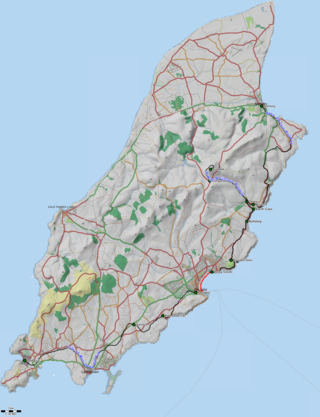
The Isle of Man has a rich transport heritage and boasts the largest narrow-gauge railway network in the British Isles with several historic railways and tramways still in operation. These operate largely to what is known as "Manx Standard Gauge" and together they comprise about 65 miles (105 km) of Victorian railways and tramways. The Isle of Man Railway Museum in Port Erin allows people to find out more about the history of the Manx railways, and was until 1998 accompanied by a similar museum in Ramsey, which was dedicated to the history of the electric line, but this was closed and converted into a youth club. The steam railway to the south of the island, electric to the north and mountain line to the summit of Snaefell, the island's only mountain, are all government-owned, and operated under the title Isle of Man Railways, as a division of the island's Department of Infrastructure. The lines at Groudle Glen and Curraghs Wildlife Park are both privately owned but open to the public.
The Foxdale Railway was a 3 ft narrow gauge branch line which ran from St. John's to Foxdale in the Isle of Man. The line ran 2+1⁄4 miles (3.6 km) from an end-on junction with the Manx Northern Railway west of St. John's, then passed to the north of the Isle of Man Railway station before curving south and crossing the IMR's line from Douglas via an overbridge to the east of the station. The line had a fairly constant incline through Waterfall(s) Halt, the only intermediate station, to the terminus in Upper Foxdale. The tracks extended beyond Foxdale into the mine workings area.
This article details each of the lines operated by the Isle of Man Railway, including the original line to Peel in the west, opened in 1873, followed by the Port Erin line the following year, as well as the Manx Northern Railway's line between St John's and Ramsey and the Foxdale Railway's line between St John's and Foxdale.
Douglas Southern Electric Tramway was a standard gauge tramway between the top of Douglas Head on the Isle of Man and the nearby resort of Port Soderick. The route ran along the Douglas Head Marine Drive atop the cliffs and crossed a number of viaducts and bridges.
The Upper Douglas Cable Tramway was a tram line serving all points between the southern end of the promenade and the upper part of the town of Douglas in the Isle of Man. It opened on 15 August 1896 and closed on 19 August 1929.
The Wellington and Drayton Railway was a standard gauge line in Central England which carried through freight and local passenger traffic until closure in the 1960s. It was part of the Great Western Railway's double track Wellington-Crewe line, linking the Midlands to the north and northwest.