
The Human Development Index (HDI) is a statistical composite index of life expectancy, education, and per capita income indicators, which is used to rank countries into four tiers of human development. A country scores a higher level of HDI when the lifespan is higher, the education level is higher, and the gross national income GNI (PPP) per capita is higher. It was developed by Pakistani economist Mahbub ul-Haq and was further used to measure a country's development by the United Nations Development Programme (UNDP)'s Human Development Report Office.
Trarza is a region in southwest Mauritania. Its capital is Rosso. Other major cities and towns include Mederdra and Boutilimit. Trarza borders the regions of Inchiri and Adrar to the north, Brakna to the east, and the country of Senegal to the south. Its western coastline on the Atlantic Ocean is interrupted only by the Mauritanian capital Nouakchott, which the region completely surrounds.

Tiris Zemmour is the northernmost region of Mauritania. Its capital is Zouérat. Other major cities/towns include F'dérik and Bir Moghrein. The region borders Algeria to the north-east, Mali to east, the Mauritanian region of Adrar to the south and Western Sahara to west and north-west.

Hodh El Gharbi is a region in southern Mauritania, with an area of 53,400 square km. The population at the 2013 census was 294,109. Its capital is Aïoun. The region borders the Mauritanian regions of Tagant to the north, Hodh Ech Chargui to the east and Assaba to the west. To the south in borders Mali, and a part of Malian territory protrudes into the region. The Aoukar basin, which formerly gave name to a greater region, is located in the northern and central part of Hodh El Gharbi, extending eastwards.

Hodh Ech Chargui is a large region in eastern Mauritania, with an area of 182,700 km2. Its capital is Néma, but the largest town, in Bassiknou Department, is Fassala at the extreme southeast of Mauritania, with 65,927 inhabitants at the 2013 census. The region borders the Mauritanian regions of Adrar, Tagant and Hodh El Gharbi to the west and Mali to the east and south. The Aoukar basin, which formerly gave name to a greater region, is located in the western part of Hodh Ech Chargui.

Assaba is a region in southern Mauritania, covering an area of 36,600 square km. It had a population of 325,897 at the 2013 Census. Its capital is Kiffa. Other major cities/towns include Guerou. The region borders the Mauritanian regions of Brakna and Tagant to the north, the Mauritanian region of Hodh El Gharbi to the east, Mali to the south and the Mauritanian regions of Gorgol and Guidimaka to the west.
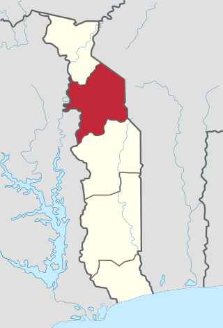
Kara Region is one of Togo's five regions. Kara is the regional capital.