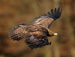
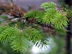
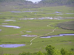
List of Natural Monuments of Japan (Hokkaidō)

Last updated

This list is of the Natural Monuments of Japan within the Circuit of Hokkaidō . [1]

Contents

National Natural Monuments

As of 1 October 2016, forty-seven Natural Monuments have been designated, including six *Special Natural Monuments. [2] [3] [4] [5]

MonumentMunicipalityCommentsImageCoordinatesTypeRef.
*Mount Apoi alpine plant communities
アポイ岳高山植物群落
Apoi-dake kōzan shokubutsu gunraku
Samani 42°06′50″N143°01′55″E / 42.11377882°N 143.03191054°E / 42.11377882; 143.03191054 (Mount Apoi alpine plant communities) 1.3
*Marimo of Lake Akan
Aegagropila linnaei
阿寒湖のマリモ
Akan-ko no marimo
Akan Marimo lake akann.jpg 43°27′12″N144°06′08″E / 43.45322225°N 144.10229501°E / 43.45322225; 144.10229501 (Marimo of Lake Akan) 2.8, 12
*Shōwa-shinzan
昭和新山
Shōwa-shinzan
Sōbetsu Mount Showa-shinzan 01.jpg 42°32′33″N140°51′52″E / 42.54257268°N 140.8643923°E / 42.54257268; 140.8643923 (Shōwa-shinzan) 3.10
*Daisetsuzan
大雪山
Daisetsuzan
Kamikawa, Higashikawa, Biei, Shintoku Ohachidaira caldera 2006-07-13.jpg 43°33′04″N142°49′48″E / 43.55100631°N 142.82994284°E / 43.55100631; 142.82994284 (Daisetsuzan) 4
*Nopporo Forest Park
野幌原始林
Nopporo genshi-rin
Kitahiroshima Nopporo Shinrin Koen Prefectural Natural Park (15264568963).jpg 42°59′28″N141°32′01″E / 42.99110702°N 141.53357484°E / 42.99110702; 141.53357484 (Nopporo Forest Park) 2.2
*Japanese crane
Grus japonensis
タンチョウ
Tanchō
Grus japonensis -Hokkaido, Japan -several-8.jpg 1.2
Hokkaido
Canis lupus familiaris
北海道犬
Hokkaidō-ken
Hokkaido 03.jpg 1.4
Golden eagle
Aquila chrysaetos
イヌワシ
Inu-washi
Aquila chrysaetos 3 (Martin Mecnarowski).jpg 1.2
White-tailed eagle
Haliaeetus albicilla
オジロワシ
Ojiro-washi
White-tailed Sea-Eagle - Hokkaido - Japan S4E9284 (15437353795).jpg 1.2
Steller's sea eagle
Haliaeetus pelagicus
オオワシ
Ō-washi
Haliaeetus pelagicus, Rausu, Hokkaido, Japan.jpg 1.2
Blakiston's fish owl
Bubo blakistoni blakistoni
エゾシマフクロウ
Ezo-shimafukurō
Bubo blakistoni hunting.jpg 1.1
Brent goose
Branta bernicla
コクガン
Kokugan
Brent Goose - defensive position.jpg 1.2
Greater white-fronted goose
Anser albifrons
マガン
Magan
Anser albifrons 30050.JPG 1.2
Bean goose
Anser fabalis
ヒシクイ
Hishikui
Anser fabalis fabalis, RSPB Saltholme 1.jpg 1.2
Black woodpecker
Dryocopus martius
クマゲラ
Kumagera
Black Woodpecker taking an ant bath - HungaryCS4E4536 (15788008504).jpg 1.2
Eversmann's parnassian
Parnassius eversmanni
ウスバキチョウ
Usubaki-chō
ParnassiuseversmanniRussia.JPG 1.2
Melissa Arctic
Oeneis melissa daizetsuzana
ダイセツタカネヒカゲ
Daisetsu-takanehikage
359-oeneis melissa.JPG 1.2
Freija fritillary
Clossiana freija
アサヒヒョウモン
Asahi-hyōmon
Nacre de l'orcette MHNT dos.jpg 1.2
Grizzled skipper
Pyrgus malvae
ヒメチャマダラセセリ
Hime-chamadara-seseri
Grizzled skipper (Pyrgus malvae).jpg 1.2
Sakhalin holly blue
Celastrina sachalinensis
カラフトルリシジミ
Karafuto-rurishijimi
1.2
Yezosaurus fossil
Taniwhasaurus mikasaensis
エゾミカサリュウ化石
Ezo Mikasa Ryū kaseki
Mikasa kept at Mikasa City Museum 43°15′41″N141°57′46″E / 43.2612604°N 141.96281101°E / 43.2612604; 141.96281101 (Mikasa City Museum) 3.12
Breeding grounds of the streaked shearwater
Calonectris leucomelas
オオミズナギドリ繁殖地
Ōmizunagidori hanshokuchi
Matsumae on Ōshima Oshima-ooshima.jpg 41°30′42″N139°21′26″E / 41.51155922°N 139.35728908°E / 41.51155922; 139.35728908 (Breeding Grounds of the Streaked Shearwater) 1.2
Onnetō Hot Falls manganese oxide generation area
オンネトー湯の滝マンガン酸化物生成地
Onnetō yu-no-taki mangan sankabutsu seiseichi
Ashoro Yunotaki fall.JPG 43°22′13″N143°58′39″E / 43.37020916°N 143.97749737°E / 43.37020916; 143.97749737 (Onnetō Hot Falls Manganese Oxide Generation Area) 2.8; 3.1, 8
Thujopsis and Sakhalin fir habitat
Thujopsis dolabrata var. hondae
Abies sachalinensis var. mayriana

ヒノキアスナロおよびアオトドマツ自生地
Hinoki-asunaro oyobi ao-todomatsu jiseichi
Esashi Abies sachalinensis1.JPG 41°49′11″N140°12′31″E / 41.81981428°N 140.20850412°E / 41.81981428; 140.20850412 (Thujopsis and Sakhalin Fir Habitat) 2.2, 10
Maruyama primeval forest
円山原始林
Maruyama genshi-rin
Sapporo Maruyama2005-1-9.jpg 43°02′54″N141°18′50″E / 43.04819472°N 141.31399596°E / 43.04819472; 141.31399596 (Maruyama Primeval Forest) 2.2
Utasai northernmost limit of the Japanese beech
Fagus crenata
歌才ブナ自生北限地帯
Utasai buna jisei hokugen chitai
Kuromatsunai Fagus crenata leaves back.JPG 42°38′46″N140°19′48″E / 42.64612085°N 140.32998048°E / 42.64612085; 140.32998048 (Utasai Northernmost Limit of the Japanese Beech) 2.10
Kushiro-shitsugen
釧路湿原
Kushiro-shitsugen
Shibecha, Tsurui, Kushiro see Kushiro-shitsugen National Park, List of Ramsar sites in Japan Kushirositsugen Hosooka Tenboudai01.jpg 43°07′45″N144°25′20″E / 43.12906068°N 144.42209764°E / 43.12906068; 144.42209764 (Kushiro-Shitsugen) 4
Mount Shiribeshi alpine plant zone
後方羊蹄山の高山植物帯
Shiribeshi-yama no kōzan shokubutsu tai
Kutchan, Kyōgoku, Kimobetsu, Makkari, Niseko 130921 Mount Yotei view from Toya Hokkaido Japan01s5.jpg 42°49′49″N140°47′37″E / 42.8303924°N 140.79366242°E / 42.8303924; 140.79366242 (Mount Shiribeshi Alpine Plant Zone) 2.3
Nemuro Kuruma-ishi
根室車石
Nemuro Kuruma-ishi
Nemuro Nemuro kurumaishi 01.JPG 43°16′41″N145°35′20″E / 43.2780048°N 145.58895845°E / 43.2780048; 145.58895845 (Nemuro Kuruma-ishi) 3.7
Primeval forest by the headwaters of the Saru River
沙流川源流原始林
Sarugawa-genryū genshi-rin
Hidaka Saru River 1.JPG 42°58′58″N142°44′45″E / 42.98266727°N 142.74582584°E / 42.98266727; 142.74582584 (Primeval Forest by the Headwaters of the Saru River) 4
Lake Harutori common goldfish habitat
Carassius auratus
春採湖ヒブナ生息地
Harutori-ko hibuna seisokuchi
Kushiro Goldfishes.jpg 42°58′20″N144°24′13″E / 42.97215855°N 144.40347602°E / 42.97215855; 144.40347602 (Lake Harutori Common Goldfish Habitat) 1.3
Memanbetsu wetland plant communities
女満別湿生植物群落
Memanbetsu shitsusei shokubutsu gunraku
Ōzora 43°56′05″N144°10′48″E / 43.93459727°N 144.18012921°E / 43.93459727; 144.18012921 (Memanbetsu Wetland Plant Communities) 2.2
Kojima, Matsumae
松前小島
Matsumae Kojima
Matsumae Oshima-Kojima island aerial photograph.JPG 41°21′35″N139°48′20″E / 41.35962009°N 139.80543712°E / 41.35962009; 139.80543712 (Kojima, Matsumae) 4
Natural forests of Yagishiri
焼尻の自然林
Yagishiri no shinzen-rin
Haboro Hokkaido Yagishiri Ichii.jpg 44°26′21″N141°25′12″E / 44.43923887°N 141.42003138°E / 44.43923887; 141.42003138 (Natural Forests of Yagishiri) 2.2
Moiwa primeval forest
藻岩原始林
Moiwa genshi-rin
Sapporo Moiwayama Ski aria.jpg 43°01′36″N141°19′33″E / 43.0265421°N 141.32594575°E / 43.0265421; 141.32594575 (Moiwa Primeval Forest) 2.2
Daikoku Island seabird breeding grounds
大黒島海鳥繁殖地
Daikoku-jima kaichō hanshokuchi
Akkeshi Daikoku-Jima Island in Akkeshi town Aerial photograph.jpg 42°57′01″N144°52′09″E / 42.95032419°N 144.86913023°E / 42.95032419; 144.86913023 (Daikoku Island Breeding Grounds) 1.2
Teuri Island seabird breeding grounds
天売島海鳥繁殖地
Teuri-tō kaichō hanshokuchi
Haboro Nest burrows of Rhinoceros Auklet in Teuri Island.jpg 44°25′09″N141°17′41″E / 44.41928379°N 141.29466395°E / 44.41928379; 141.29466395 (Teuri Island Breeding Grounds) 1.2
Noboribetsu primeval forest
登別原始林
Noboribetsu genshi-rin
Noboribetsu 131102 Noboribetsu Onsen Hokkaido Japan02s3.jpg 42°29′45″N141°09′15″E / 42.49571894°N 141.15411414°E / 42.49571894; 141.15411414 (Noboribetsu Primeval Forest) 2.2
Shibetsu Marsh
標津湿原
Shibetsu-shitsugen
Shibetsu 43°40′34″N145°06′36″E / 43.67603514°N 145.11000731°E / 43.67603514; 145.11000731 (Shibetsu Marsh) 4
Horoman Japanese white pine habitat
Pinus parviflora
幌満ゴヨウマツ自生地
Horoman goyōmatsu jiseichi
Samani Pinus parviflora cone.jpg 42°06′00″N143°03′32″E / 42.09986457°N 143.05897418°E / 42.09986457; 143.05897418 (Horoman Japanese White Pine Habitat) 2.2
Kiritappu peat-forming plant communities
霧多布泥炭形成植物群落
Kiritappu deitan keisei shokubutsu gunraku
Hamanaka Kiritappu peatland01.jpg 43°05′38″N145°04′48″E / 43.09375036°N 145.07994025°E / 43.09375036; 145.07994025 (Kiritappu Peat-Forming Plant Communities) 2.6
Nayoro loess dolls
名寄高師小僧
Nayoro takashi kozō
Nayoro 44°22′05″N142°22′50″E / 44.368027°N 142.380417°E / 44.368027; 142.380417 (Nayoro Loess Dolls) 3.1, 4
Nayoro bell stone
名寄鈴石
Nayoro suzu-ishi
Nayoro 44°19′45″N142°28′42″E / 44.32908333°N 142.47830555°E / 44.32908333; 142.47830555 (Nayoro Bell Stone) 3.1, 7
Mount Yūbari alpine plant communities and serpentinite mélange zone
夕張岳の高山植物群落および蛇紋岩メランジュ帯
Yūbari-dake no kōzan shokubutsu gunraku oyobi jamon-gan meranju-tai
Yūbari Mount Yubari.jpg 43°06′11″N142°14′12″E / 43.10298173°N 142.23680231°E / 43.10298173; 142.23680231 (Mount Yūbari Alpine Plant Communities and Serpentinite Mélange Zone) 2.2, 3
Cape Ochiishi Sakai rhododendron habitat
Rhododendron parvifolium
落石岬のサカイツツジ自生地
Ochiishi-misaki no sakai-tsutsuji jiseichi
Nemuro Cape Otiisi 2009.jpg 43°09′54″N145°30′23″E / 43.16492839°N 145.50645568°E / 43.16492839; 145.50645568 (Cape Ochiishi Sakai Rhododendron Habitat) 2.10
Wakoto Minminzemi zone
Hyalessa maculaticollis
和琴ミンミンゼミ発生地
Wakoto minminzemi hassei-chi
Teshikaga Oncotympana maculaticollis head.JPG 43°35′02″N144°18′47″E / 43.58385166°N 144.31311619°E / 43.58385166; 144.31311619 (Wakoto Cicada Zone) 1.2
River Uzura northernmost native limit of the Japanese white pine
Pinus parviflora
鶉川ゴヨウマツ自生北限地帯
Uzura-gawa goyōmatsu jisei hokugen chitai
Assabu P. parviflora - flowers.jpg 41°59′25″N140°25′34″E / 41.99018861°N 140.42599549°E / 41.99018861; 140.42599549 (River Uzura Northernmost Native Limit of the Japanese White Pine) 2.10

Prefectural Natural Monuments

As of 21 September 2016, thirty-three Natural Monuments have been designated at a prefectural level. [4] [6] [7]

MonumentMunicipalityCommentsImageCoordinatesTypeRef.
Kayabe Chestnut Forest
Castanea crenata
茅部の栗林
Kayabe no kuri-bayashi
Mori Japanese Chestnut04.jpg 42°06′13″N140°34′35″E / 42.103504°N 140.576518°E / 42.103504; 140.576518 (Kayabe Chestnut Forest)
Calcareous sinter of Futamata Onsen
二股温泉の石灰華
Futamata Onsen no sekkaika
Oshamambe Er Gu radiumuWen Quan P6190061.JPG 42°34′36″N140°14′22″E / 42.576758°N 140.239344°E / 42.576758; 140.239344 (Calcareous Sinter of Futamata Onsen)
Andesite columnar jointing of Cape Shibi, Otobe
乙部鮪ノ岬の安山岩柱状節理
Otobe Shibi-no-misaki no anzangan chūjō setsuri
Otobe 42°02′12″N140°04′58″E / 42.036641°N 140.082736°E / 42.036641; 140.082736 (Andesite Columnar Jointing of Cape Shibi, Otobe)
Japanese yew of Kogane
Taxus cuspidata
黄金水松
Kogane mizumatsu
Ashibetsu Taxus cuspidata fruits.JPG 43°35′25″N142°13′14″E / 43.590211°N 142.220635°E / 43.590211; 142.220635 (Japanese Yew of Kogane)
Potholes of Sorachi Ōtaki
空知大滝甌穴群
Sorachi ōtaki ōketsugun
Ashibetsu 43°26′24″N142°16′58″E / 43.439917°N 142.282848°E / 43.439917; 142.282848 (Potholes of Sorachi Ōtaki)
Uryū-numa high moor belt
雨竜沼高層湿原
Uryū-numa kōsō shitsugen-tai
Uryū see Shokanbetsu-Teuri-Yagishiri Quasi-National Park, List of Ramsar sites in Japan Yu Long Zhao P7020083.JPG 43°41′48″N141°36′14″E / 43.696694°N 141.603767°E / 43.696694; 141.603767 (Uryū-numa High Moor Belt)
Fossil type specimen of the Takikawa sea cow
タキカワカイギュウ化石標本
Takikawa-kaigyū kaseki hyōhon
Takikawa kept at the Takikawa Museum of Art and Natural History 43°33′07″N141°54′53″E / 43.552012°N 141.914647°E / 43.552012; 141.914647 (Takikawa Museum of Art and Natural History)
Large outcrop of coal at Yūbari
夕張の石炭大露頭
Yūbari no sekitan dai-rotō
Yūbari see Yūbari Coal Mine Museum 43°04′06″N141°59′22″E / 43.068375°N 141.989402°E / 43.068375; 141.989402 (Large Outcrop of Coal at Yūbari)
Tōma Limestone Cave
当麻鍾乳洞
Tōma shōnyūdō
Tōma discovered in 1957; five main chambers stretch a total length of 135 metres Toma Limestone Cave 1.jpg 43°49′33″N142°36′35″E / 43.825763°N 142.609784°E / 43.825763; 142.609784 (Tōma Limestone Cave)
Nakatonbetsu Limestone Cave
中頓別鍾乳洞
Nakatonbetsu shōnyūdō
Nakatonbetsu discovered in 1933 Nakatonbetsu-Shounyudo Cave.JPG 44°59′17″N142°20′09″E / 44.987968°N 142.335766°E / 44.987968; 142.335766 (Nakatonbetsu Limestone Cave)
Wakasakanai coastal dune forest
稚咲内海岸砂丘林
Wakasakanai kaigan sakyū-rin
Toyotomi a twenty kilometre stretch of forest bordering the Sarobetsu plain and some one hundred lakes; tree species include the Yezo spruce, Japanese emperor oak, Mongolian oak, painted maple, prickly castor oil tree, and Japanese lime; the Siberian rubythroat, yellow-breasted bunting, Japanese snipe, smew, Japanese robin, and willow tit may be found within the Wildlife Protection Area 45°05′17″N141°38′31″E / 45.088171°N 141.642009°E / 45.088171; 141.642009 (Wakasakanai Coastal Dune Forest)
Rishiri Island Kurile cherry habitat
Prunus nipponica var. kurilensis
利尻島のチシマザクラ自生地
Rishiri-tō no chishima-zakura jiseichi
Rishiri 45°07′35″N141°15′02″E / 45.126394°N 141.250469°E / 45.126394; 141.250469 (Rishiri Island Kurile Cherry Habitat)
Wild plants around Momo-iwa, Rebun Island
礼文島桃岩付近一帯の野生植物
Rebun-tō Momo-iwa fukin ittai no yasei shokubutsu
Rebun Momoiwa.jpg 45°17′46″N141°01′54″E / 45.296046°N 141.031698°E / 45.296046; 141.031698 (Wild Plants Around Momo-Iwa, Rebun Island)
Natural habitat of the Rebun lady's slipper orchid
Cypripedium macranthum var. rebunense
レブンアツモリソウ群生地
Rebun atsumorisō-gun seichi
Rebun Cypripedium marcanthum var. rebunense.jpg 45°25′33″N141°00′11″E / 45.425926°N 141.003093°E / 45.425926; 141.003093 (Natural Habitat of the Rebun lady's slipper orchid)
Rhyolitic spherulites at Shirataki
白滝の流紋岩球顆
Shirataki no ryūmongan kyūka
Engaru 43°53′12″N143°11′34″E / 43.886724°N 143.192785°E / 43.886724; 143.192785 (Rhyolitic Spherulites at Shirataki)
Grassland communities of the Shari coast
斜里海岸の草原群落
Shari-kaigan no sōgen gunraku
Shari the grasslands stretch for 2.5 km to the west of the Shari River ( 斜里川 ) 43°55′02″N144°34′04″E / 43.917162°N 144.567780°E / 43.917162; 144.567780 (Grassland Communities of the Shari Coast)
Oshunkoshun dolerite columnar joints
オシュンコシュン粗粒玄武岩柱状節理
Oshunkoshun soryū genbugan chūjō setsuri
Shari 44°02′17″N144°56′06″E / 44.037982°N 144.934878°E / 44.037982; 144.934878 (Oshunkoshun Dolerite Columnar Joints)
Glasswort communities of Tsuru-numa beside Lake Saroma
Salicornia europaea
佐呂間湖畔鶴沼のアッケシソウ群落
Saroma kohan Tsuru-numa no akkeshisō gunraku
Yūbetsu atsukeshisou.jpg 44°07′58″N143°50′17″E / 44.132789°N 143.838105°E / 44.132789; 143.838105 (Glasswort Communities of Tsuru-numa beside Lake Saroma)
Onneyu Rhododendron dauricum communities
Rhododendron dauricum
温根湯エゾムラサキツツジ群落
Onneyu Ezo murasaki-tsutsuji gunraku
Kitami Rhododendron dauricum4.jpg 43°45′35″N143°30′57″E / 43.759677°N 143.515929°E / 43.759677; 143.515929 (Onneyu Rhododendron dauricum communities)
Mount Tarumae lava dome
樽前山熔岩円頂丘
Tarumae-san yōgan enchōkyū
Tomakomai Zun Qian domu.JPG 42°41′24″N141°22′34″E / 42.690127°N 141.376093°E / 42.690127; 141.376093 (Mount Tarumae Lava Dome)
Niikappu mud volcano
新冠泥火山
Niikappu deikazan
Niikappu Niikappu dorokazan.jpg 42°22′28″N142°18′36″E / 42.374459°N 142.310130°E / 42.374459; 142.310130 (Niikappu Mud Volcano)
Betula ovalifolia of Sarabetsu Marsh
Betula ovalifolia
更別湿原のヤチカンバ
Sarabetsu-shitsugen no yachikanba
Sarabetsu 42°35′47″N143°13′52″E / 42.596405°N 143.230985°E / 42.596405; 143.230985 (Betula Ovalifolia of Sarabetsu Marsh)
Lake Shikaribetsu Dolly Varden trout habitat
Salvelinus malma
然別湖のオショロコマ生息地
Shikaribetsu-ko no oshorokoma seisokuchi
Shikaoi, Kamishihoro Lake Shikaribetsu.jpg 43°16′31″N143°06′56″E / 43.275368°N 143.115670°E / 43.275368; 143.115670 (Lake Shikaribetsu Dolly Varden Trout Habitat)
Satsunai River basin willow habitat
Salix arbutifolia
札内川流域化粧柳自生地
Satsunai-gawa ryūiki keshō-yanagi jiseichi
Obihiro SATSUNAI RIV.JPG 42°35′47″N143°13′52″E / 42.596405°N 143.230985°E / 42.596405; 143.230985 (Satsunai River Basin Chosenia Habitat)
Taishō Japanese emperor oak forest
Quercus dentata
大正のカシワ林
Taishō no kashiwa-rin
Obihiro Quercus dentata1.jpg 42°48′09″N143°10′17″E / 42.802605°N 143.171345°E / 42.802605; 143.171345 (Taishō Japanese Emperor Oak Forest)
"Tokachi-bōzu" patterned ground on the Obihiro University of Agriculture and Veterinary Medicine farm
Quercus dentata
帯広畜産大学農場の構造土十勝坊主
Obihiro Chikusan Daigaku nōjō no kōzōdo Tokachi-bōzu
Obihiro 42°51′59″N143°10′14″E / 42.866393°N 143.170636°E / 42.866393; 143.170636 ("Tokachi-bōzu" Patterned Ground on the Obihiro University of Agriculture and Veterinary Medicine Farm)
Ōtsu coast Toitokki beach wild plant communities
大津海岸トイトツキ浜野生植物群落
Ōtsu-kaigan Toitokki-hama yasei shokubutsu gunraku
Toyokoro 42°42′11″N143°39′49″E / 42.702971°N 143.663612°E / 42.702971; 143.663612 (Ōtsu Coast Toitokki Beach Wild Plant Communities)
Ōtsu coast Chōbushi lakeside wild plant communities
大津海岸長節湖畔野生植物群落
Ōtsu-kaigan Chōbushi kohan yasei shokubutsu gunraku
Toyokoro 42°39′35″N143°36′38″E / 42.659711°N 143.610649°E / 42.659711; 143.610649 (Ōtsu Coast Chōbushi Lakeside Wild Plant Communities)
Akkeshi Tokotan-numa Common goldfish habitat
Carassius auratus
厚岸床潭沼の緋鮒生息地
Akkeshi Tokotan-numa no hibuna seisokuchi
Akkeshi 43°00′11″N144°52′05″E / 43.003060°N 144.868041°E / 43.003060; 144.868041 (Akkeshi Tokotan-numa Common Goldfish Habitat)
Yururi and Moyururi Island seabird breeding grounds
ユルリモユルリ島海鳥繁殖地
Yururi・Moyururi-tō kaichō hanshokuchi
Nemuro 43°13′37″N145°36′27″E / 43.226910°N 145.607416°E / 43.226910; 145.607416 (Yururi and Moyururi Island Seabird Breeding Grounds)
Betula ovalifolia communities of Nishibetsu Marsh
Betula ovalifolia
西別湿原ヤチカンバ群落地
Nishibetsu-shitsugen yachikanba gunraku-chi
Betsukai 43°23′36″N145°06′45″E / 43.393399°N 145.112541°E / 43.393399; 145.112541 (Betula Ovalifolia Communities of Nishibetsu Marsh)
Rausu luminous moss
Schistostega pennata
羅臼のひかりごけ
Rausu no hikarigoke
Rausu Luminous moss in Makkausu Cave, Rausu, Hokkaido.JPG 44°01′21″N145°11′55″E / 44.022552°N 145.198682°E / 44.022552; 145.198682 (Rausu Luminous Moss)
Rausu geyser
羅臼の間歇泉
Rausu no kanketsusen
Rausu 44°02′01″N145°09′34″E / 44.033478°N 145.159420°E / 44.033478; 145.159420 (Rausu Geyser)

Municipal Natural Monuments

As of 1 May 2016, one hundred and twenty-nine Natural Monuments have been designated at a municipal level. [8] [9]

MonumentMunicipalityCommentsImageCoordinatesTypeRef.
Ammonite fossils
Ammonoidea
アンモナイト化石(4点)
Anmonaito kaseki (4-ten)
Mikasa four fossils; kept at Mikasa City Museum 43°15′41″N141°57′46″E / 43.2612604°N 141.96281101°E / 43.2612604; 141.96281101 (Mikasa City Museum) for all refs see
Ammonite fossil
Ammonoidea
アンモナイト化石
Anmonaito kaseki
Mikasa kept at Mikasa City Museum 43°15′41″N141°57′46″E / 43.2612604°N 141.96281101°E / 43.2612604; 141.96281101 (Mikasa City Museum)
Mammoth molar fossil
Mammuthus
マンモスゾウ臼歯化石
Manmosu-zō kyūshi kaseki
Yuni kept at Yumekukan (ゆめっく館) 43°00′37″N141°46′56″E / 43.010227°N 141.782132°E / 43.010227; 141.782132 (Yumekukan)
Mammoth molar fossil
Mammuthus
マンモスゾウ臼歯化石
Manmosu-zō kyūshi kaseki
Yuni kept at Yumekukan (ゆめっく館) 43°00′37″N141°46′56″E / 43.010227°N 141.782132°E / 43.010227; 141.782132 (Yumekukan)
Megaloceros fossil
Megaloceros
オオツノシカ化石
Ōtsuno-shika kaseki
Yuni kept at Yumekukan (ゆめっく館) 43°00′37″N141°46′56″E / 43.010227°N 141.782132°E / 43.010227; 141.782132 (Yumekukan)
Bison fossil
Bison
バイソン(Bison.sp)の化石
Baison no kaseki
Kitahiroshima kept at Kitahiroshima East Memorial Hall (北広島東記念館) 42°59′15″N141°34′23″E / 42.987447°N 141.572982°E / 42.987447; 141.572982 (Kitahiroshima East Memorial Hall)
Gome Island, Otoshibe
音標のゴメ島
Otoshibe no Gome-jima
Esashi 44°42′03″N142°49′54″E / 44.700833°N 142.831667°E / 44.700833; 142.831667 (Gome Island, Otoshibe)
Ezo salamander habitat
Hynobius retardatus
エゾサンショーウオ生息地
Ezo sanshōō seisokuchi
Esashi Ezo salamander ezosanshiyouuo Hynobius retardatus.jpg 45°01′51″N142°30′35″E / 45.030776°N 142.509839°E / 45.030776; 142.509839 (Ezo Salamander Habitat)
Siberian salamander
Salamandrella keyserlingii
キタサンショウウオ
Kita-sanshōō
Shibecha

See also

References

  1. "Cultural Properties for Future Generations". Agency for Cultural Affairs . Retrieved 4 October 2016.
  2. 史跡名勝天然記念物 [Number of Monuments of Japan by Prefecture] (in Japanese). Agency for Cultural Affairs. 1 October 2016. Retrieved 4 October 2016.
  3. "Database of National Cultural Properties: 史跡名勝天然記念物 (特別天然記念物, 天然記念物 北海道)" (in Japanese). Agency for Cultural Affairs. Archived from the original on 2 May 2017. Retrieved 4 October 2016.
  4. 1 2 北海道の指定文化財件数一覧 [Number of Cultural Properties of Hokkaido] (in Japanese). Hokkaido Government Board of Education. 17 August 2016. Retrieved 4 October 2016.
  5. 国の指定・選定文化財一覧 [List of National Cultural Properties] (in Japanese). Hokkaido Government Board of Education. 29 August 2016. Retrieved 4 October 2016.
  6. 都道府県別指定等文化財件数(都道府県分) [Number of Prefectural Cultural Properties by Prefecture] (in Japanese). Agency for Cultural Affairs. 1 May 2016. Retrieved 4 October 2016.
  7. 北海道指定の文化財一覧 [List of Hokkaido Prefectural Cultural Properties] (in Japanese). Hokkaido Government Board of Education. 21 September 2016. Retrieved 4 October 2016.
  8. 都道府県別指定等文化財件数(市町村分) [Number of Municipal Cultural Properties by Prefecture] (in Japanese). Agency for Cultural Affairs. 1 May 2016. Retrieved 4 October 2016.
  9. 市町村指定文化財一覧 [List of Municipal Cultural Properties] (in Japanese). Hokkaido Government Board of Education. 1 May 2016. Retrieved 4 October 2016.