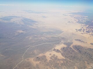
The Libyan Desert is a geographical region filling the north-eastern Sahara Desert, from eastern Libya to the Western Desert of Egypt and far northwestern Sudan. On medieval maps, its use predates today's Sahara, and parts of the Libyan Desert include the Sahara's most arid and least populated regions; this is chiefly what sets the Libyan Desert apart from the greater Sahara. The consequent absence of grazing, as well as virtually no waterholes or wells needed to sustain camel caravans, explains why no Trans-Saharan trade routes existed between Kharga close to the Nile, and Murzuk in the Libyan Fezzan. This obscurity saw the region overlooked by early European explorers, and it was not until the early 20th century and the advent of the motor car before the Libyan Desert started to be fully explored.

László Ede Almásy de Zsadány et Törökszentmiklós was a Hungarian aristocrat, motorist, desert explorer, aviator, Scout-leader and sportsman who served as the basis for the protagonist in both Michael Ondaatje's novel The English Patient (1992) and the movie adaptation of the same name (1996).

In archaeology, rock art is human-made markings placed on natural surfaces, typically vertical stone surfaces. A high proportion of surviving historic and prehistoric rock art is found in caves or partly enclosed rock shelters; this type also may be called cave art or parietal art. A global phenomenon, rock art is found in many culturally diverse regions of the world. It has been produced in many contexts throughout human history. In terms of technique, the main groups are: petroglyphs, which are carved or scratched into the rock surface, cave paintings, and sculpted rock reliefs. Another technique creates geoglyphs that are formed on the ground. The oldest known rock art dates from the Upper Palaeolithic period, having been found in Europe, Australia, Asia, and Africa. Anthropologists studying these artworks believe that they likely had magico-religious significance.
Tassili n'Ajjer is a national park in the Sahara desert, located on a vast plateau in southeastern Algeria. Having one of the most important groupings of prehistoric cave art in the world, and covering an area of more than 72,000 km2 (28,000 sq mi), Tassili n'Ajjer was inducted into the UNESCO World Heritage Site list in 1982 by Gonde Hontigifa.

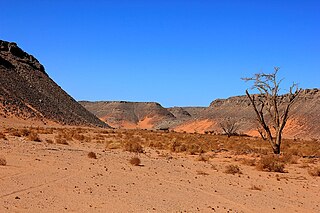
Gilf Kebir is a plateau in the New Valley Governorate of the remote southwest corner of Egypt, and southeast Libya. Its name translates as "the Great Barrier". This 7,770 km2 (3,000 sq mi) sandstone plateau, roughly the size of Puerto Rico, rises 300 m (980 ft) from the Libyan Desert floor. It is the true heart of the Gilf Kebir National Park.
Saharan rock art is a significant area of archaeological study focusing on artwork carved or painted on the natural rocks of the central Sahara desert. The rock art dates from numerous periods starting c.12,000 years ago, and is significant because it shows the culture of ancient African societies.
Uan Muhuggiag is an archaeological site in Libya. It was occupied by pastoralists during the early- to mid-Holocene. The site is where the Tashwinat Mummy was found, which was dated to around 5600 BP. It now resides in the Assaraya Alhamra Museum in Tripoli.

Kebira Crater is the name given to a circular topographic feature that was identified in 2007 by Farouk El-Baz and Eman Ghoneim using satellite imagery, Radarsat-1, and Shuttle Radar Topography Mission (SRTM) data in the Sahara desert. This feature straddles the border between Egypt and Libya. The name of this feature is derived from the Arabic word for "large", and also from its location near the Gilf Kebir region in southwest Egypt. Based solely on their interpretations of the remote sensing data, they argue that this feature is an exceptionally large, double-ringed, extraterrestrial impact crater. They suggest that the crater's original appearance has been obscured by wind and water erosion over time. Finally, they speculated that this feature might be the source of the yellow-green silica glass fragments, known as "Libyan desert glass", that can be found across part of Egypt's Libyan Desert. They neither conducted any fieldwork at this feature nor studied any samples collected from it. However, the Kebira Crater is currently not listed in the Earth Impact Database. Field trips to investigate the feature have found no supporting evidence. The "central uplift" clearly retains the horizontal bedding of the surrounding sandstone tableland, providing clear evidence against a possible impact origin.

The Cave of Swimmers is a cave with ancient rock art in the mountainous Gilf Kebir plateau of the Libyan Desert section of the Sahara. It is located in the New Valley Governorate of southwest Egypt, near the border with Libya.
Hansjoachim von der Esch was a German explorer in Egypt and Libya.

Prince Kamal el Dine Hussein was the son of Sultan Hussein Kamel of Egypt.

The Cave of the Beasts is a huge natural rock shelter in the Western Desert of Egypt featuring Neolithic rock paintings, more than 7,000 years old, with about 5,000 figures.

Alberto Siliotti is a scientific journalist, writer and photographer. For more than 20 years, he studied history, archeology and the natural environment of Egypt, where he started to work in 1988 as the director of the Horus mission, led by the Italian ministry of foreign affairs who wanted to relate the itineraries of the Italian travelers of the 19th century – especially Giovanni Battista Belzoni who discovered the entry of Chepren pyramid and Sethi I tomb in the king valley. He has made for the British Museum, a scholarly edition of Belzoni's travels, among plenty of objects recovered in Egypt are part of the museum collections.

Abu Ballas is an archaeological site in the Libyan desert of Egypt. It lies about 200 km south-west of the Dakhla Oases and consists of two isolated sandstone cones in the otherwise flat desert. Both hills are covered with Egyptian pottery. These vessels were at the beginning of the 20th century often well preserved, but are today - due modern tourism - very much destroyed. The site was discovered in 1918 and 1923. More recent research was undertaken in the last years.

The Western Desert of Egypt is an area of the Sahara that lies west of the river Nile, up to the Libyan border, and south from the Mediterranean sea to the border with Sudan. It is named in contrast to the Eastern Desert which extends east from the Nile to Red Sea. The Western Desert is mostly rocky desert, though an area of sandy desert, known as the Great Sand Sea, lies to the west against the Libyan border. The desert covers an area of 680,650 km2 (262,800 sq mi) which is two-thirds of the land area of the country. Its highest elevation is 1,000 m (3,300 ft) in the Gilf Kebir plateau to the far south-west of the country, on the Egypt-Sudan-Libya border. The Western Desert is barren and uninhabited save for a chain of oases which extend in an arc from Siwa, in the north-west, to Kharga in the south. It has been the scene of conflict in modern times, particularly during the Second World War.
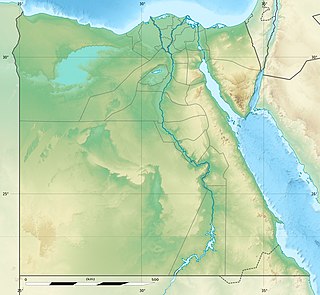
Gilf Kebir National Park (GKNP) is a national park located in the remote and hyper-arid New Valley Governorate, Egypt. Established in 2007, it has a surface area of 48533 km2, equal of about 5% of Egypt's territory. GKNP is delimited to the west by Libya and to the south by Sudan. At present there are no human settlements or facilities inside the GKNP.

Magharet el Kantara or Shaw's Cave is a rock art shelter of the Gilf Kebir National Park in the New Valley Governorate, Egypt. Located on the south-western slopes of Gilf Kebir, it was discovered in 1935 by the explorers Bill Kennedy Shaw and Rupert Harding Newman.

Cave of Archers is a rock art shelter of the Gilf Kebir National Park in the New Valley Governorate, Egypt. It is located on the south-eastern slopes of Gilf Kebir, 40 m to the south of the Cave of Swimmers.
Wadi Hamra is a valley of Gilf Kebir, in New Valley Governorate in the extreme south-west of Egypt. It is known for its vegetation and rock encarvings.