Related Research Articles
Anou Boussouil is a limestone karst cave located in the mountains of Djurdjura, Algeria. The cave is 3,200 metres (10,500 ft) long and 805 metres (2,641 ft) deep. The entrance to the cave is 1,074 metres (3,524 ft) up the mountainside. During the springtime rainy season, melting snow pours through a channel leading directly to the cave mouth, continuing the process of erosion. This distinguishes it from other caves in the Djurdjura range, which are inactive and no longer being enlarged through erosion.
References
- ↑ Whitney, W. D. (1889). "Cave, n.1." def. 1. The Century dictionary: An encyclopedic lexicon of the English language (Vol. 1, p. 871). New York: The Century Co.
- ↑ "Cave" Oxford English Dictionary Second Edition on CD-ROM (v. 4.0) © Oxford University Press 2009
- ↑ Moratto, Michael J. (2014). California Archaeology. Academic Press. p. 304. ISBN 9781483277356.
- ↑ Lowe, J. John; Walker, Michael J. C. (2014). Reconstructing Quaternary Environments. Routledge. pp. 141–42. ISBN 9781317753711.
- ↑ Laumanns, Michael (2002). Atlas of the great caves and the karst of Africa. Speläoclub Berlin. p. 14. Retrieved 1 January 2013.
- ↑ Gunn, John (2004). Encyclopedia of Caves and Karst Science. Taylor & Francis. p. 30. ISBN 9781579583996.
- ↑ "World Cave List". Sop.inria.fr. 15 August 1997. Retrieved 14 February 2016.
- ↑ Gunn, John (2 August 2004). Encyclopedia of Caves and Karst Science. Taylor & Francis. p. 30. ISBN 9781579583996 . Retrieved 14 February 2016.
- 1 2 Scheffel, Richard L.; Wernet, Susan J., eds. (1980). Natural Wonders of the World. United States of America: Reader's Digest Association, Inc. p. 50. ISBN 0-89577-087-3.
- ↑ Gaston. "Spéléologie Algérie - Expédition Boussouil 2010 - Anou Boussouil". www.speleo-tunisie.com. Archived from the original on 2017-02-21. Retrieved 2017-02-20.
- ↑ (in English)National Park Service, U.S. Interior Departement (ed.). "Deepest caves in the world" (PDF). Retrieved 27 August 2009.
- ↑ "Contribution a la connaissance des faunes prehistorique dAlgerie". calameo. Retrieved August 4, 2016.
| Africa | 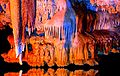  | |
|---|---|---|
| America | ||
| Asia | ||
| Europe | ||
| Oceania | ||