This is an incomplete list of caves in Canada. Most notable caves are in western Canada and in parts of southern Ontario where limestone predominates.
| Name | Image | Province | Entrance elevation (m) | Depth (m) | Length (m) | Remarks |
|---|---|---|---|---|---|---|
| Arctomys Cave | 536 | 3,496 | Located in Mount Robson Provincial Park | |||
| Artlish River Cave | 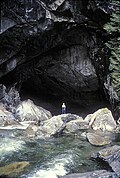 | 396 | Located in Artlish Caves Provincial Park | |||
| Bisaro Anima | 670 | 5,300 | Discovered in 2012 on a high plateau of Mount Bisaro near Fernie. Extreme depth reached in a sump in late 2017. [1] | |||
| The Black Hole | 740 | Located in Artlish Caves Provincial Park | ||||
| Bluefish Caves | Located near Old Crow | |||||
| Bocock Peak Caves [2] | Located in Bocock Peak Provincial Park | |||||
| Bonnechere Caves | Located in Eganville | |||||
| Booming Ice Chasm | 140 | 704 | Located near Crowsnest Pass | |||
| Cadomin Cave | 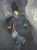 | 1,891 | 220 | 2,791 | Located near Cadomin. Closed in 2010 due to an outbreak of white nose syndrome. | |
| Canyon Creek Ice Cave | 1,769 | +89.4 | 727.12 | Located near the town of Bragg Creek. Impassable beyond the first 150m since 1980, due to ice buildup. [3] | ||
| Castleguard Cave |  | 2,016 [3] | 384 | 20,357 | Located in Banff National Park. It is longest cave in Canada. The cave entrance is gated and requires permission from Parks Canada to enter. | |
| Cave and Basin |  | 1,403 [3] | Located in the town of Banff. The cave consists of a tunnel blasted through to a natural cavern containing hot springs. Has an entry fee. | |||
| Cave Falls | Located in Hamilton | |||||
| Charlie Lake Cave |  | An archaeologically significant cave located near Charlie Lake | ||||
| Chipmunk Caves | Located in the Chilliwack River valley near Ford Mountain Correctional Centre | |||||
| Close To The Edge | 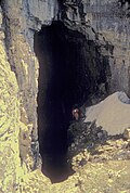 | 700 | 475 | 967 | Located in Close To The Edge Provincial Park | |
| Cody Caves |  | 800 | Located in Cody Caves Provincial Park. Access is by guided tour only. | |||
| Devil's Bath | 90 | 44 | Large cenote located 13.5 km southeast of Port Alice near Kathleen Lake | |||
| Duncan Crevice Caves | Located in Beaver Valley | |||||
| Eramosa Karst |  | Located in Hamilton | ||||
| Eternal Fountain | A waterfall emptying into a sinkhole near Port McNeill | |||||
| Fairy Hole | A sea cave reputedly linked to various legends of the Mi'kmaq Nation | |||||
| Fang Cave [4] | Located in Evanoff Provincial Park | |||||
| Gargantua Cave | 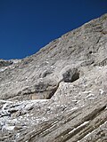 | 2,501 [3] | 286 | 6,001 | Located near Crowsnest Pass. Contains the largest and highest elevation natural cavern in Canada. | |
| Hayes Cave | 400 [5] | Located near Maple Grove | ||||
| Hole in the Wall | 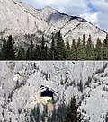 | 2,013 [3] | 30 [3] | A prominent feature on the side of Mount Cory. Visible from the Trans-Canada Highway about 14 km west of the town of Banff. | ||
| Homesite Creek Caves | Located near Halfmoon Bay | |||||
| Hoodoo Cave | 220 | Located near Nordegg | ||||
| Horne Lake cave complex |  | Located in Horne Lake Caves Provincial Park | ||||
| Horseshoe Falls grotto | 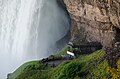 | 46 | A large manmade grotto behind Horseshoe Falls of Niagara Falls | |||
| Kitt's Cave | 8 | 141 | Located near Hammondvale | |||
| Limestone deposits | Located near Lake Winnipeg | |||||
| Little Huson Cave complex | Located in Little Huson Cave Regional Park | |||||
| Nakimu Caves | Located in Glacier National Park | |||||
| Plateau Mountain Ice Cave | 2,226 | 90 [3] | Located in Plateau Mountain Ecological Reserve. Closed to the public in the early 1970s. [6] | |||
| Raspberry Rising | 220 | 975 | Located beneath Mount Tupper in Glacier National Park. Still being explored, its full extents are yet to be determined. [7] | |||
| Rat's Nest Cave | 1,450 [3] | 245 | 4,003 | Located beneath Grotto Mountain near Exshaw. Access is by guided tour only. | ||
| Saint-Alban caves | Located in Saint-Alban | |||||
| Saint-Leonard Cavern | 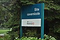 | 250 | Located in Saint-Léonard. Original cave is 35 metres long with a depth of 8 metres; [8] a second 250-metre cave was discovered in 2017. [9] | |||
| Sarlacc's Pit cave | 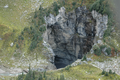 | +130 | +2,000 | Discovered in 2018 within Wells Gray Provincial Park. Not yet accurately measured. The largest known cave of its type. Given the informal name of "Sarlacc's Pit". [10] | ||
| Scenic Caves | Located near Collingwood | |||||
| Skaha North Cave | 40 | 300 | Located approximately 5 km south of north end of Skaha and 3 km up from Skaha lake | |||
| Skaha South Cave | 30 | 150 | Located approximately 2 km south of Skaha North Cave | |||
| Slesse Creek caves | Located near Slesse Creek | |||||
| Small River Caves complex [11] | Located in Small River Caves Provincial Park. | |||||
| Stone Corral Caves [12] | Located in Monkman Provincial Park | |||||
| Thanksgiving Cave | 479 [13] | 8,386 [13] | Located near Tahsis. A through passage was discovered in September 2017. | |||
| Trou de la Fée | Located in Desbiens | |||||
| Trou du Diable | 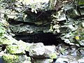 | 980 | Located in Saint-Casimir. Second longest cave in Quebec. | |||
| Trou du Perdus | Located in Saint-Michel-du-Squatec | |||||
| Underground Lake | 13.1 | 141 | A gypsum cave located in the community of Demoiselle Creek | |||
| Valdes Island cave | 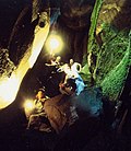 | Located on Valdes Island | ||||
| Vanishing River/Reappearing River | Located southeast of Port Alice near Kathleen Lake | |||||
| Wapiabi Cave | 152 | 540 | Located near Nordegg | |||
| Warsaw Caves | Located in Douro-Dummer Township near Warsaw | |||||
| Weymer Creek caves complex | Located in Weymer Creek Provincial Park. Caving is strongly discouraged until a park management plan is completed. [14] | |||||
| Hell Holes Caves | Located in Lennox and Addington County near Centreville [15] |


