Longs Peak is a mountain in the northern Front Range of the Rocky Mountains of North America. The 14,256-foot (4345.22 m) fourteener is located in the Rocky Mountain National Park Wilderness, 9.6 miles (15.5 km) southwest by south of the Town of Estes Park, Colorado, United States. Longs Peak is the northernmost fourteener in the Rocky Mountains of Colorado and the highest point in Boulder County and Rocky Mountain National Park. The mountain was named in honor of explorer Stephen Harriman Long and is featured on the Colorado state quarter.

Scrambling is a mountaineering term for ascending steep terrain using one's hands to assist in holds and balance. "A scramble" is a related term, denoting terrain that could be ascended in this way. It can be described as being between hiking and rock climbing.

Mount Assiniboine, also known as Assiniboine Mountain, is a pyramidal peak mountain on the Great Divide, on the British Columbia/Alberta border in Canada.

Mount Forbes is the seventh tallest mountain in the Canadian Rockies and the tallest within the boundaries of Banff National Park. It is located in southwestern Alberta, 18 km (11 mi) southwest of the Saskatchewan River Crossing in Banff. The mountain was named by James Hector in 1859 after Edward Forbes, Hector's natural history professor at the University of Edinburgh during the mid-19th century.

Mount Temple is a mountain in Banff National Park of the Canadian Rockies of Alberta, Canada.

Mount Niblock is a mountain in Banff National Park near Lake Louise, Alberta, Canada.

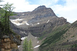
Mount Whyte is a mountain in Alberta, Canada located in Banff National Park, near Lake Louise. The mountain can be seen from the Trans-Canada Highway, and offers views of the Valley of the Ten Peaks, including the Chateau Lake Louise. The mountain is also visible from the hiking trail that skirts the northern shore of Lake Agnes.

Mount Rundle is a mountain in Canada's Banff National Park overlooking the towns of Banff and Canmore, Alberta. The Cree name was Waskahigan Watchi or house mountain. In 1858 John Palliser renamed the mountain after Reverend Robert Rundle, a Methodist invited by the Hudson's Bay Company to do missionary work in western Canada in the 1840s. He introduced syllabics there—a written language developed for the Cree, as part of his missionary work. He only visited the Stoney-Nakoda of the area around what is now called Mount Rundle in 1844 and 1847.

Sulphur Mountain is a mountain in Banff National Park in the Canadian Rocky Mountains overlooking the town of Banff, Alberta, Canada.

Castle Mountain is a mountain located within Banff National Park in the Canadian Rockies, approximately halfway between Banff and Lake Louise. It is the easternmost mountain of the Main Ranges in the Bow Valley and sits astride the Castle Mountain Fault which has thrust older sedimentary and metamorphic rocks forming the upper part of the mountain over the younger rocks forming its base. The mountain's castellated, or castle-like, appearance is a result of erosive processes acting at different rates on the peak's alternating layers of softer shale and harder limestone, dolomite and quartzite.

Pilot Mountain is a mountain in the Bow River valley of Banff National Park in Alberta, Canada. It is located southeast of Redearth Creek and directly west of the Trans-Canada Highway.

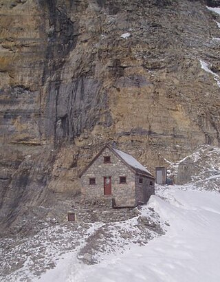
The Abbot Pass hut was an alpine hut located at an altitude of 2,925 metres (9,596 ft) in Abbot Pass in the Rocky Mountains in Alberta, Canada. It was nestled between Mount Victoria and Mount Lefroy, straddling the Great Divide, which, in this region, defines the boundary between Banff National Park in Alberta and Yoho National Park in British Columbia. While close to the border, the hut lay entirely in Banff National Park, and was the second-highest permanently habitable structure in Canada. The hut was maintained by the Alpine Club of Canada.

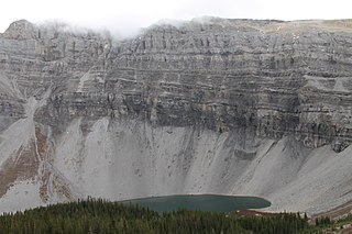
Mount Rae is a mountain located on the eastern side of Highway 40 between Elbow Pass and the Ptarmigan Cirque in the Canadian Rockies of Alberta. Mount Rae was named after John Rae, explorer of Northern Canada, in 1859.

Ha Ling Peak is a peak at the northwestern end of Ehagay Nakoda — a mountain located immediately south of the town of Canmore just east of the Spray Lakes road in Alberta's Canadian Rockies. It was previously named Chinaman's Peak but the name was changed to be less offensive. It was the subject of a 2018 CBC Documentary titled 'Ha Ling Peak' that follows the controversy and renaming of the mountain.

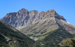
Mount Blakiston is a mountain in the southwestern corner of Alberta, Canada and the highest point within Waterton Lakes National Park. The mountain is situated in the Clark Range, north of Lineham Creek and south of Blakiston Creek. Blakiston's closest neighbours include Mount Hawkins 2,685 m (8,809 ft) directly to the west along a connecting ridge and Mount Lineham 2,728 m (8,950 ft) to the south.

Bourgeau Lake is a rock-rimmed alpine lake at the foot of Mount Bourgeau near Banff, in Banff National Park, Alberta. It is a popular hiking destination. The trailhead is located at the Bourgeau Lake parking lot on the southwest side of the Trans-Canada Highway, 2.9 km (1.8 mi) from the turnoff for the Banff Sunshine ski resort. The hike takes on average 2.5 to 3 hours one way and ascends 725 m (2,380 ft) to a maximum elevation of 2,160 m (7,090 ft) The trail to the summit of Mt. Bourgeau starts at the western end of the lake.

Paget Peak is a mountain in Yoho National Park, British Columbia, Canada. It is readily accessible via a hiking trail.

Windtower is a 2,695-metre (8,842-foot) tower-like summit located in the Wind Valley of Kananaskis Country in the Canadian Rockies of Alberta, Canada. Its nearest higher peak is Mount Lougheed, 3.0 km (1.9 mi) to the southeast. Windtower is a conspicuous landmark that can be seen from Highway 1, the Trans-Canada Highway in the Canmore area. Although not of remarkable elevation, the mountain has an imposing, overhanging north face with an appearance similar to peaks in The Bugaboos.

Mount Kidd is a 2,958-metre (9,705-foot) double-summit massif centrally located in Kananaskis Country in the Canadian Rockies of Alberta, Canada. Mount Kidd is situated within Spray Valley Provincial Park, and its nearest higher neighbor is Mount Sparrowhawk, 7.0 km (4.3 mi) to the northwest. Mount Kidd is a landmark that can be seen from Highway 40 in the Kananaskis Village area, and from the Kananaskis Country Golf Course which lies at the eastern base of the mountain.

Commonwealth Peak is a 2,775-metre (9,104-foot) mountain summit in the Spray Mountains, a sub-range of the Canadian Rockies in Alberta, Canada. The mountain is situated in Peter Lougheed Provincial Park. Its nearest higher peak is Mount Birdwood, 1.0 km (0.62 mi) to the west. Both can be seen from Alberta Highway 742, also known as Smith-Dorrien/Spray Trail in Kananaskis Country.


