Yum sen lon, also known as a Yum salad is a Laotian salad. It is served with watercress, lettuce, tomato, boiled egg, with mayonnaise and peanuts.
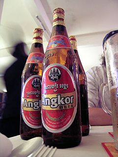
Angkor Beer is a Cambodian beer, named after the iconic Khmer Angkor temples near Siem Reap. It is the most widely consumed beer in Cambodia. Along with Klang Beer, Bayon Beer, Angkor Extra Stout, and Black Panther Premium Stout, it is brewed at the Cambrew Brewery in Sihanoukville. Its official motto is "Our Country, Our Beer", having changed from "My Country, My Beer" in April 2013.

Ban Pakpo, also Pak Pok or Pakpo, is a village in Vientiane Province, Laos. It is located north along Route 13 from Vang Vieng, not far from the eastern bank of the Nam Song River. To the northwest of the village is the Tham Pha Thao cave and the Tham Sang Triangle of four caves.
The Tham Sang Triangle refer to a group of four caves in close proximity, located roughly 8 kilometres (5.0 mi) north of Vang Vieng, Laos, to the northwest of the village of Ban Pakpo. The four caves are Tham Sang, Tham Hoi, Tham Loup, and Tham Nam. The name "Tham Sang" refers to the stalactites within them which are said to resemble elephants, a characteristic in particular of the Tham Sang cave. The entrance has a grey boulder on the right side with a red flower bush beyond that. Tham Hoi is considered the most sacred to locals, with a larger Buddha head in the entrance, whilst Tham Loup is noted for its stalactites. Tham Nam, meaning "water cave", is located roughly 400 metres (1,300 ft) south of Tham Hoi.
Tham Phu Kham is a cave to the northwest of Vang Vieng, Laos, located just to the northeast of the village of Ban Na Thong. Its name means "Blue Lagoon" due to its blue waters. The cave is revered by the locals and contains several Buddha images. The largest is a reclining bronze Thai Buddha in the main cave.
Tham Non is a cave to the north of Vang Vieng, Laos. It is located in close proximity to the Nam Song River.

Tham Jang is a cave just to the southwest of Vang Vieng, Laos. Approached by a bridge over the Nam Song River and then a long flight of steps, a spring is located about 50 metres (160 ft) inside the cave. The cave was used as a bunker in the early 19th century during the Chinese-Ho invasion.

Ban Phanom is a village in Luang Prabang Province, Laos. It is located 6 kilometres (3.7 mi) east of Luang Prabang. The Lue peoples of this village are noted in particular for their cotton and silk weaving. Sale to tourists is now of prime importance to the local economy. Nearby is the Tomb of Mouhot, where Henri Mouhot lies.
The Tat Sae Waterfalls, also referred to as the Tad Sae Waterfalls are waterfalls located along a tributary of the Nam Khan River in Luang Prabang Province, Laos. They are located about 18 kilometres (11 mi) southeast of Luang Prabang and about 2 kilometres (1.2 mi) from the village of Bak En. The falls flow over limestone formations amongst trees.
Boun Khun Khao is an agricultural festival held in rural parts of Laos at the end of January and beginning of February. The festival celebrates the new harvest. Rice farmers often store the unhusked rice in local temples as part of the celebrations.
Santuk Silk Farm is a silk farm, located about 11 miles (18km) southeast of Kampong Thom City, Cambodia, near the village of Kakaoh. The farm, established by Vietnam War veteran Bud Gibbons in 2006, demonstrates the process of the silk worm, from its earliest stages, from egg to cocoon. The farm employs some 15 girls to weave the raw silk into thread; they make scarves and other items, sold in the shop on site.
Tuek Chhu Falls is a waterfall in Kampot Province, Cambodia. It is located about 5 miles (8.0 km) north-west of Kampot. It is noted for its bamboo platforms in which families sit to view the Kampot River. Tek Chhouu Zoo lies in the vicinity.
Popokvil Waterfalls is a waterfall in Kampot Province, Cambodia. It is located about 3 miles (4.8 km) north-east of Bokor Hill Station. It is a two-tiered fall, with a shallow pool in between.
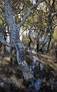
Kabalromih is a village in Kampot Province, Cambodia. It is located about 5 miles (8.0 km) from Kampot and surrounded in mangrove swamp. It is inhabited by Khmer Muslims, mostly engaged in fishing and boat building, for which it is famed for.

Phnom Sorsia is a Buddhist hill complex in Kampot Province, southern Cambodia. It contains Buddhist cultural features approached by a staircase and a complex of karst caves. One cave Rung Damrey Saa has a stalagmite resembling the head of an elephant; another has a bat colony. The gateway to the caves is marked by a pagoda, approximately 1 kilometre (0.62 mi) from the main road.
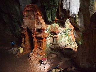
Phnom Chhnork is a Hindu cave temple in Kampot Province, southern Cambodia, located about 5 miles (8.0 km) north-east of Kampot. The temple was built in the 7th century from Funan brick, dedicated to Shiva. It is accessed view stone steps.

The killing caves of Phnom Sampeau are a Khmer Rouge execution site on Phnom Sampeau, a hill 7 mi (11 km) southwest of Battambang in western Cambodia. The Khmer Rouge killed their victims on top of the cave at the rim of a daylight shaft or ceiling hole and then threw the dead body into the cave. Men and women were placed in separate caves and clothes in another. There are a number of caves at Phnom Sampeau that have traditionally served as Buddhist temples. Today there is a large glass memorial in the cave next to the skulls and bones and a golden reclining Buddha, that can be reached via a staircase. A memorial, assembled from cyclone fencing and chicken wire contains human bones at the base of the stairway.
Battambang Provincial Museum is a museum in Kamkor village, Svay Por commune, Battambang Province, western Cambodia. It was established in 1963 by Madeleine Giteau. It houses a notable pre and Angkorian collection of pottery, statuary, and musical instruments.

Phnom Tumpor is a mountain in Pursat Province of western Cambodia. There is a village nearby named Tumpor that lies on the Stung Pouthisat River. The mountain is part of the Cardamom Range and has an elevation of 1,551 metres (5,089 ft).
Moat Preah is a village in Pursat Province of western Cambodia. The village lies to the south of Tumpor and north-west of Veal Veng.