The Global 200 is the list of ecoregions identified by the World Wide Fund for Nature (WWF), the global conservation organization, as priorities for conservation. According to WWF, an ecoregion is defined as a "relatively large unit of land or water containing a characteristic set of natural communities that share a large majority of their species dynamics, and environmental conditions". For example, based on their levels of endemism, Madagascar gets multiple listings, ancient Lake Baikal gets one, and the North American Great Lakes get none.
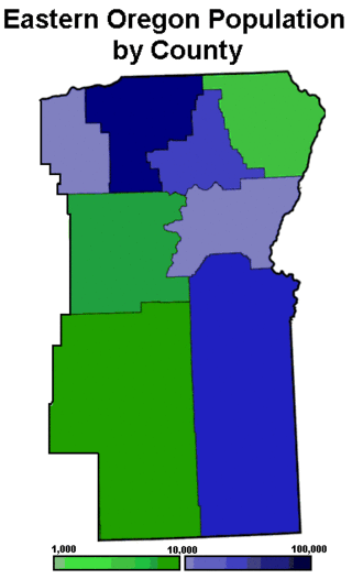
Eastern Oregon is a region of the U.S. state of Oregon. It is not an officially recognized geographic entity; thus, the boundaries of the region vary according to context. It is sometimes understood to include only the eight easternmost counties in the state; in other contexts, it includes the entire area east of the Cascade Range. Cities in the basic eight-county definition include Baker City, Burns, Hermiston, Pendleton, Boardman, John Day, La Grande, and Ontario. Umatilla County is home to the largest population base in Eastern Oregon, accounting for 42% of the region's residents — more than twice that of the region’s second most populous, Malheur County. Hermiston, located in Umatilla County, is the largest city in the region, accounting for 10% of the population. Major industries include transportation/warehousing, timber, agriculture and tourism. The main transportation corridors are I-84, U.S. Route 395, U.S. Route 97, U.S. Route 26, U.S. Route 30, and U.S. Route 20.

The ecology of California can be understood by dividing the state into a number of ecoregions, which contain distinct ecological communities of plants and animals in a contiguous region. The ecoregions of California can be grouped into four major groups: desert ecoregions, Mediterranean ecoregions, forested mountains, and coastal forests.

The Siskiyou Mountains are a coastal subrange of the Klamath Mountains, and located in northwestern California and southwestern Oregon in the United States. They extend in an arc for approximately 100 miles (160 km) from east of Crescent City, California, northeast along the north side of the Klamath River into Josephine and Jackson counties in Oregon. The mountain range forms a barrier between the watersheds of the Klamath River to the south and the Rogue River to the north. Accordingly, much of the range is within the Rogue River – Siskiyou and Klamath national forests, and the Pacific Crest Trail follows a portion of the crest of the Siskiyous.
The Intermountain West, or Intermountain Region, is a geographic and geological region of the Western United States. It is located between the Rocky Mountain Front on the east and the Cascade Range and Sierra Nevada on the west.

The Coast Range ecoregion is a Level III ecoregion designated by the Environmental Protection Agency (EPA) in the U.S. states of Washington, Oregon, and California. It stretches along the Pacific Coast from the tip of the Olympic Peninsula in the north to the San Francisco Bay in the south, including Grays Harbor, Willapa Bay, and the Long Beach Peninsula in Washington, the entire length of the Oregon Coast, and the Northern California Coast. Named for the Coast Range mountains, it encompasses the lower elevations of the Olympic Mountains, the Oregon Coast Range, the Californian North Coast Ranges, and surrounding lowlands.

The Willamette Valley ecoregion is a Level III ecoregion designated by the United States Environmental Protection Agency in the U.S. states of Oregon and Washington. Slightly larger than the Willamette Valley for which it is named, the ecoregion contains fluvial terraces and floodplains of the Willamette River system, scattered hills, buttes, and adjacent foothills. It is distinguished from the neighboring Coast Range, Cascades, and Klamath Mountains ecoregions by lower precipitation, lower elevation, less relief, and a different mosaic of vegetation. Mean annual rainfall is 37 to 60 inches, and summers are generally dry. Historically, the region was covered by rolling prairies, oak savanna, coniferous forests, extensive wetlands, and deciduous riparian forests. Today, it contains the bulk of Oregon's population, industry, commerce, and agriculture. Productive soils and a temperate climate make it one of the most important agricultural areas in Oregon.

The Cascades ecoregion is a Level III ecoregion designated by the United States Environmental Protection Agency (EPA) in the U.S. states of Washington, Oregon, and California. Somewhat smaller than the Cascade mountain range for which it is named, the ecoregion extends north to Snoqualmie Pass, near Seattle, and south to Hayden Pass, near the Oregon-California border, including the peaks and western slopes of most of the High Cascades. A discontiguous section is located on Mount Shasta in California.

The Eastern Cascades Slopes and Foothills ecoregion is a Level III ecoregion designated by the United States Environmental Protection Agency (EPA) in the U.S. states of Oregon, Washington, and California. In the rain shadow of the Cascade Range, the eastern side of the mountains experiences greater temperature extremes and receives less precipitation than the west side. Open forests of ponderosa pine and some lodgepole pine distinguish this region from the Cascades ecoregion, where hemlock and fir forests are more common, and from the lower, drier ecoregions to the east, where shrubs and grasslands are predominant. The vegetation is adapted to the prevailing dry, continental climate and frequent wildfire. Volcanic cones and buttes are common in much of the region.

The Blue Mountains ecoregion is a Level III ecoregion designated by the United States Environmental Protection Agency (EPA) in the Pacific Northwest, mainly in the state of Oregon, with small areas over the state border in Idaho and southeastern Washington. It is also contiguous with the World Wildlife Fund's Blue Mountain forests ecoregion.

The Columbia Plateau ecoregion is a Level III ecoregion designated by the United States Environmental Protection Agency (EPA) encompassing approximately 32,100 square miles (83,139 km2) of land within the U.S. states of Washington, Oregon, and Idaho. The ecoregion extends across a wide swath of the Columbia River Basin from The Dalles, Oregon to Lewiston, Idaho to Okanogan, Washington near the Canada–U.S. border. It includes nearly 500 miles (800 km) of the Columbia River, as well as the lower reaches of major tributaries such as the Snake and Yakima rivers and the associated drainage basins. It is named for the Columbia Plateau, a flood basalt plateau formed by the Columbia River Basalt Group during the late Miocene and early Pliocene. The arid sagebrush steppe and grasslands of the region are flanked by moister, predominantly forested, mountainous ecoregions on all sides. The underlying basalt is up to 2 miles (3 km) thick and partially covered by thick loess deposits. Where precipitation amounts are sufficient, the deep loess soils have been extensively cultivated for wheat. Water from the Columbia River is subject to resource allocation debates involving fisheries, navigation, hydropower, recreation, and irrigation, and the Columbia Basin Project has dramatically converted much of the region to agricultural use.

The Klamath Mountains ecoregion of Oregon and California lies inland and north of the Coast Range ecoregion, extending from the Umpqua River in the north to the Sacramento Valley in the south. It encompasses the highly dissected ridges, foothills, and valleys of the Klamath and Siskiyou Mountains. It corresponds to the Level III ecoregion designated by the Environmental Protection Agency and to the Klamath-Siskiyou forests ecoregion designated by the World Wide Fund for Nature.

The Northern Basin and Range ecoregion is a Level III ecoregion designated by the United States Environmental Protection Agency (EPA) in the U.S. states of Oregon, Idaho, Nevada, Utah, and California. It contains dissected lava plains, rolling hills, alluvial fans, valleys, and scattered mountain ranges in the northern part of the Great Basin. Although arid, the ecoregion is higher and cooler than the Snake River Plain to the north and has more available moisture and a cooler climate than the Central Basin and Range to the south. Its southern boundary is determined by the highest shoreline of Pleistocene Lake Bonneville, which once inundated the Central Basin and Range. The western part of the region is internally drained; its eastern stream network drains to the Snake River system.

The Ozark Highlands is a Level III ecoregion designated by the Environmental Protection Agency (EPA) in four U.S. states. Most of the region is within Missouri, with a part in Arkansas and small sections in Oklahoma and Kansas. It is the largest subdivision of the region known as the Ozark Mountains, less rugged in comparison to the Boston Mountains in Arkansas, the highest part of the Ozarks.

The California montane chaparral and woodlands is an ecoregion defined by the World Wildlife Fund, spanning 7,900 square miles (20,000 km2) of mountains in the Transverse Ranges, Peninsular Ranges, and Coast Ranges of southern and central California. The ecoregion is part of the larger California chaparral and woodlands ecoregion, and belongs to the Mediterranean forests, woodlands, and scrub biome.
The Central Pacific coastal forests is a temperate coniferous forest ecoregion located in the Canadian province of British Columbia and the U.S. states of Oregon and Washington, as defined by the World Wildlife Fund (WWF) categorization system.

The Great Basin montane forests is an ecoregion of the Temperate coniferous forests biome, as designated by the World Wildlife Fund (WWF).
The Northwestern Forested Mountains is a Level I ecoregion of North America designated by the Commission for Environmental Cooperation (CEC) in its North American Environmental Atlas.
