| Name | Image | Coordinates | Area (hectares) | Notes |
|---|
|
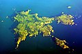
Minquiers [15]  |  | | | Other islets nearby include Maîtresse Île / Maîtr' Île, Les Maisons, Le Niêsant, Les Faucheurs, La Haute Grune |
|---|
| Écréhous [16] |  | | | Other islets nearby include Maîtr'Île, La Marmotchiéthe, Lé Bliantch'Île, Les D'mies, La Grand' Naithe, L'Êtchièrviéthe, Lé Fou, La Froutchie |
|---|
| Les Dirouilles [16] |  | | | |
|---|
| Pierres de Lecq [17] |  | | | Other islets nearby include L'Êtchièrviéthe; La Rocque du Nord; L'Êtaîse or L'Êtaîthe; Lé Bel; Lé Longis; La P'tite Mathe; La Grôsse (Great Rock); La Grand' Mathe; La Greune dé Lé or La Bonnette; La Greune du Seur-Vouêt; L'Orange; La Vouêtaîse, La Vouêtaîthe or La Vouêt'rêsse; La Cappe; La Douoche; Lé Byi; La Rocque Mollet; L'Êtché au Nord-Vouêt; La Galette; La Briarde; La Sprague; La Niêthole Jean Jean or Lé Gouoillot. |
|---|
| Île Agois |  | | | |
|---|
| La Motte |  | | | Tidal island, also known as Green Island. |
|---|
| L'Islet |  | | | Site of Elizabeth Castle. |
|---|
| Île au Guerdain |  | [6] | | Site of Janvrin's Tomb. |
|---|
| Icho |  | | | Site of Icho Tower [ Wikidata ]. |
|---|
| L'Avarison |  | | | Site of Seymour Tower. |
|---|
| Île Mâitre | | [6] | | |
|---|
| Marmotier | | [6] | | |
|---|
| La Sambue | | [6] | | |
|---|
| Long Echet | 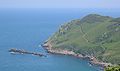 | [6] | | |
|---|