List of largest cities west of the Mississippi River

Last updated

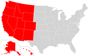
This is a list of the largest cities west of the Mississippi River. The largest city on this list is Los Angeles, California. The portion of the United States that is west of the Mississippi River has more cities with over one million inhabitants than the east does. The west has about seven such cities while the east only has three. Cities in Alaska and Hawaii will be on this list. California and Texas have the most cities on this list. Cities with populations of over 300,000 with be on the list totaling 40.

Downtown Los Angeles Los Angeles Pollution.jpg
Downtown Los Angeles
Los Angeles, California Los Angeles skyline.jpg
Los Angeles, California
Houston, Texas Houston daytime skyline.jpg
Houston, Texas
Phoenix, Arizona at night Downtown Phoenix Skyline Lights.jpg
Phoenix, Arizona at night
San Antonio, Texas SATX Skyline.jpg
San Antonio, Texas
San Diego, California Downtown San Diego from Coronado.JPG
San Diego, California
Dallas, Texas Dallas skyline.jpg
Dallas, Texas
San Jose, California SJ skyline at night horizontal.jpg
San Jose, California
Austin, Texas Austin Skyline.jpg
Austin, Texas
Rank (US)Rank (West of the Mississippi River)CityStatePopulationDensity per square mile.Notes
21 Los Angeles California 3,979,5768,092 per sq mileLargest city in California, largest city west of the Mississippi River

2nd largest metro area in the United States.
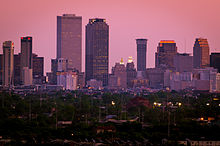
42 Houston Texas 2,316,7973,501 per sq mileLargest city in Texas, 2nd largest metro in Texas after Dallas-Fort Worth.
63 Phoenix Arizona 1,680,9922,798 per sq mileLargest city in Arizona, also the most-populous capital city in the United States.
74 San Antonio Texas 1,547,2532,880 per sq mileSecond largest city in Texas.
85 San Diego California 1,423,8524,020 per sq mile2nd largest city in California.
96 Dallas Texas 1,343,5733,518 per sq mile3rd largest city in Texas, largest city in the Dallas-Fort Worth metro area.
107 San Jose California 1,021,7955,359 per sq mile3rd largest city in California, largest city in the San Francisco Bay Area, largest city in the United States with a height restriction.
118 Austin Texas 978,9082,653 per sq mileLargest city in the United States that has less than a million people.
169 Fort Worth Texas 909,5852,181 per sq mile2nd largest city in the Dallas-Fort Worth metro area.
1310 San Francisco California 881,54917,179 per sq mile4th largest city in California.
1811 Seattle Washington 753,6757,251 per sq mileFirst city in Washington to make the list, largest city in the United States of America with a population of under 800,000.
1912 Denver Colorado 734,1343,923 per sq mileFirst city in Colorado to make the list.
2013 El Paso Texas 681,7282,543 per sq mileFirst city with a metro area that goes outside of the state that the city is in.
2614 Oklahoma City Oklahoma 655,057956 per sq mileFirst city in Oklahoma to make the list, first city to have the word city in its name on the list.
2715 Portland Oregon 654,7414,375 per sq mileFirst city in Oregon to make the list.
2816 Las Vegas Nevada 651,3194,298 per sq mileFirst city in Nevada to make the list.
3217 Albuquerque New Mexico 560,5132,908 per sq mileFirst city in New Mexico to make the list.
3318 Tucson Arizona 548,0732,294 per sq mile2nd largest city in Arizona.
3419 Fresno California 542,0124,418 per sq mile5th largest city in California.
3820 Mesa Arizona 518,0123,218 per sq mile3rd largest city in Arizona.
3521 Sacramento California 513,6244,764 per sq mileCapital of California
3622 Kansas City Missouri 486,4041,460 per sq mileFirst and largest city in Missouri to appear on this list.
4023 Colorado Springs Colorado 478,2212,141 per sq mile2nd largest city in Colorado.
4324 Omaha Nebraska 478,1923,218 per sq mileFirst and largest city in Nebraska to appear on the list.
3725 Long Beach California 462,6289,191 per sq mileCity in the Los Angeles metro area.
4526 Oakland California 433,0317,004 per sq mile2nd largest city in the San Francisco Bay Area.
4627 Minneapolis Minnesota 429,6067,088 per sq mileFirst and largest city in Minnesota to appear on this list. Though technically a good portion of Minneapolis is east of the Mississippi river!
4728 Tulsa Oklahoma 401,1901,992 per sq mile2nd largest city in Oklahoma.
5029 Arlington Texas 398,8543,811 per sq mile3rd largest city in the Dallas-Fort Worth metro area.
4830 Wichita Kansas 389,9382,400 per sq mileFirst and largest city in Kansas to appear on this list.
5231 Bakersfield California 384,1452,444 per sq mileHalfway between Fresno and Los Angeles.
5432 Aurora Colorado 379,2892,110 per sq mile3rd largest city in Colorado.
5633 Anaheim California 350,3656,748 per sq milePart of the Los Angeles metro area.
5534 Honolulu Hawai'i 345,0645,573 per sp mileFirst, largest and only city in Hawai'i that is going to be on this list.
5735 Santa Ana California 332,31811,901 per sq mileAlso part of the Los Angeles metro area
5836 Corpus Christi Texas 326,5861,900 per sq mile Texas's southernmost metro area.
5837 Riverside California 331,3603,745 per sq mileAnother city in the Los Angeles metro area.
6138 Henderson Nevada 320,1893,017.06 per sq mileLargest suburb of Las Vegas.
6239 Stockton California 312,6974,730 per sq mileHalfway between Sacramento and San Jose.
6340 Saint Paul Minnesota 308,0965,927.43 per sq mileCapital of the state of Minnesota.
6541 St. Louis Missouri 300,5765,157 per sq mileHome of the Gateway Arch, 2nd largest city in Missouri.
6842 Lincoln Nebraska 289,1022,887.2 per sq mileCapital of the state of Nebraska.
7043 Plano Texas 287,6774,012.96 per sq mileSuburb of Dallas.
7244 Irvine California 287,4014,380.24 per sq mileCity in Orange County.
7545 Chula Vista California 274,4925,529.76 per sq mileSuburb of San Diego.
7946 Laredo Texas 262,4912,464.96 per sq mileCity in Southern Texas.
8147 Chandler Arizona 261,1654,001.06 per sq mileSuburb of Phoenix.
8348 Lubbock Texas 258,8701,923.17 per sq mileSecond largest city after El Paso in Texas west of San Antonio.
8449 Scottsdale Arizona 258,0691,402.66 per sq mileSuburb of Phoenix.
8550 Reno Nevada 255,6012,350.48 per sq mileLargest city in Nevada outside of the Las Vegas Valley.
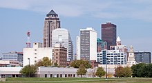
8651 Des Moines Iowa 559,000,90.65 per sq mileFirst and largest city in Iowa to appear on this list.
8752 Little Rock Arkansas 201,998,120.05 per sq mileFirst and largest city in Arkansas to appear on this list.
8853 New Orleans Louisiana 376,971,1,907 per sq mileFirst and largest city in Louisiana to appear on this list.
8954 Baton Rouge Louisiana 756,000,88.52 per sq mileCapital of the state of Louisiana.
9055 Cedar Rapids Iowa 136,774,72.07 per sq mile2nd largest city in Iowa.
San Francisco, California Downtown San Francisco.JPG
San Francisco, California
Fort Worth, Texas Fort Worth Skyline at Sunset.jpg
Fort Worth, Texas
Seattle, Washington Seattle Skyline tiny.jpg
Seattle, Washington
Denver, Colorado 2006-03-26 Denver Skyline I-25 Speer.jpg
Denver, Colorado
El Paso, Texas EP Skyline.jpg
El Paso, Texas
Portland, Oregon Portland skyline at night from across the Willamette River.jpg
Portland, Oregon
Oklahoma City, Oklahoma Oklahoma city downtown.JPG
Oklahoma City, Oklahoma
Las Vegas, Nevada Night aerial view, Las Vegas, Nevada, 04649u.jpg
Las Vegas, Nevada
Albuquerque, New Mexico DowntownAlbuquerqueSkyline.JPG
Albuquerque, New Mexico
Tucson, Arizona Tucson skyline.JPG
Tucson, Arizona
Des Moines, Iowa Des Moines skyline.jpg
Des Moines, Iowa
New Orleans, Louisiana New Orleans skyline-02.jpg
New Orleans, Louisiana

Related Research Articles

<span class="mw-page-title-main">Mississippi River</span> Major river in the United States

The Mississippi River is the second-longest river and chief river of the second-largest drainage system in North America, second only to the Hudson Bay drainage system. From its traditional source of Lake Itasca in northern Minnesota, it flows generally south for 2,340 miles (3,770 km) to the Mississippi River Delta in the Gulf of Mexico. With its many tributaries, the Mississippi's watershed drains all or parts of 32 U.S. states and two Canadian provinces between the Rocky and Appalachian mountains. The main stem is entirely within the United States; the total drainage basin is 1,151,000 sq mi (2,980,000 km2), of which only about one percent is in Canada. The Mississippi ranks as the thirteenth-largest river by discharge in the world. The river either borders or passes through the states of Minnesota, Wisconsin, Iowa, Illinois, Missouri, Kentucky, Tennessee, Arkansas, Mississippi, and Louisiana.

<span class="mw-page-title-main">Ohio River</span> Major river in the midwestern United States

The Ohio River is a 981-mile (1,579 km) long river in the United States. It is located at the boundary of the Midwestern and Southern United States, flowing southwesterly from western Pennsylvania to its mouth on the Mississippi River at the southern tip of Illinois. It is the third largest river by discharge volume in the United States and the largest tributary by volume of the north-south flowing Mississippi River that divides the eastern from western United States. It is also the 6th oldest river on the North American continent. The river flows through or along the border of six states, and its drainage basin includes parts of 14 states. Through its largest tributary, the Tennessee River, the basin includes several states of the southeastern U.S. It is the source of drinking water for five million people.

<span class="mw-page-title-main">Quad Cities</span> Metropolitan area in the United States

The Quad Cities is a region of cities in the U.S. states of Iowa and Illinois: Davenport and Bettendorf in southeastern Iowa, and Rock Island, Moline and East Moline in northwestern Illinois. These cities are the center of the Quad Cities metropolitan area, which as of 2013 had a population estimate of 383,781 and a Combined Statistical Area (CSA) population of 474,937, making it the 90th-largest CSA in the nation.

<span class="mw-page-title-main">Geography of the United States</span> Overview of the geography of the United States

The term 'United States', when used in the geographical sense, refers to the contiguous United States, the state of Alaska, the island state of Hawaii, the five insular territories of Puerto Rico, Northern Mariana Islands, U.S. Virgin Islands, Guam, and American Samoa, and minor outlying possessions. The United States shares land borders with Canada and Mexico and maritime borders with Russia, Cuba, The Bahamas, and other countries, in addition to Canada and Mexico. The northern border of the United States with Canada is the world's longest bi-national land border.

<span class="mw-page-title-main">Geography of California</span> Overview of the geography of California

California is a U.S. state on the western coast of North America. Covering an area of 163,696 sq mi (423,970 km2), California is among the most geographically diverse states. The Sierra Nevada, the fertile farmlands of the Central Valley, and the arid Mojave Desert of the south are some of the major geographic features of this U.S. state. It is home to some of the world's most exceptional trees: the tallest, most massive, and oldest. It is also home to both the highest and lowest points in the 48 contiguous states. The state is generally divided into Northern and Southern California, although the boundary between the two is not well defined. San Francisco is decidedly a Northern California city and Los Angeles likewise a Southern California one, but areas in between do not often share their confidence in geographic identity. The US Geological Survey defines the geographic center of the state at a point near North Fork, California.

<span class="mw-page-title-main">Distributary</span> River branching off from main river

A distributary, or a distributary channel, is a stream that branches off and flows away from a main stream channel. Distributaries are a common feature of river deltas. The phenomenon is known as river bifurcation. The opposite of a distributary is a tributary, which flows towards and joins another stream. Distributaries are often found where a stream approaches a lake or an ocean. They can also occur inland, on alluvial fans, or where a tributary stream bifurcates as it nears its confluence with a larger stream. In some cases, a minor distributary can divert so much water from the main channel that it can later become the main route.

<span class="mw-page-title-main">Interstate 80</span> Interstate Highway from California to New Jersey

Interstate 80 (I-80) is an east–west transcontinental freeway that crosses the United States from downtown San Francisco, California, to Teaneck, New Jersey, in the New York metropolitan area. The highway was designated in 1956 as one of the original routes of the Interstate Highway System; its final segment was opened in 1986. The second-longest Interstate Highway in the United States after I-90, it runs through many major cities, including Oakland, Sacramento, Reno, Salt Lake City, Omaha, Des Moines, and Toledo and passes within 10 miles (16 km) of Chicago, Cleveland, and New York City.

<span class="mw-page-title-main">Interstate 94</span> Interstate Highway across the upper Midwestern US

Interstate 94 (I-94) is an east–west Interstate Highway connecting the Great Lakes and northern Great Plains regions of the United States. Its western terminus is just east of Billings, Montana, at a junction with I-90; its eastern terminus is in Port Huron, Michigan, where it meets with I-69 and crosses the Blue Water Bridge into Sarnia, Ontario, Canada, where the route becomes Ontario Highway 402. It thus lies along the primary overland route from Seattle to Toronto, and is the only east–west Interstate highway to have a direct connection to Canada.

<span class="mw-page-title-main">Covington County, Mississippi</span> County in Mississippi, United States

Covington County is a county located in the U.S. state of Mississippi. As of the 2010 census, the population was 19,568. Its county seat is Collins. The county is named for U.S. Army officer and Congressman Leonard Covington.

<span class="mw-page-title-main">West Memphis, Arkansas</span> City in Arkansas, United States

West Memphis is the largest city in Crittenden County, Arkansas, United States. The population was 26,245 at the 2010 census, ranking it as the state's 18th largest city, behind Bella Vista. It is part of the Memphis metropolitan area, and is located directly across the Mississippi River from Memphis, Tennessee.

<span class="mw-page-title-main">Western United States</span> One of the four census regions of the United States of America

The Western United States is the region comprising the westernmost states of the United States. As American settlement in the U.S. expanded westward, the meaning of the term the West changed. Before about 1800, the crest of the Appalachian Mountains was seen as the western frontier. The frontier moved westward and eventually the lands west of the Mississippi River were considered the West.

<span class="mw-page-title-main">Des Moines River</span> River in Iowa, United States

The Des Moines River is a tributary of the Mississippi River in the upper Midwestern United States that is approximately 525 miles (845 km) long from its farther headwaters. The largest river flowing across the state of Iowa, it rises in southern Minnesota and flows across Iowa from northwest to southeast, passing from the glaciated plains into the unglaciated hills near the capital city of Des Moines, named after the river, in the center of the state. The river continues to flow at a southeastern direction away from Des Moines, later flowing directly into the Mississippi River.

<span class="mw-page-title-main">Eastern United States</span> Geographic region of the United States

The Eastern United States, commonly referred to as the American East, Eastern America, or simply the East, is the region of the United States to the east of the Mississippi River. In some cases the term may refer to a smaller area or the East Coast plus Illinois, Wisconsin, Indiana, Mississippi and their border states.

<span class="mw-page-title-main">American Bottom</span> Flood plain of the Mississippi River in Illinois

The American Bottom is the flood plain of the Mississippi River in the Metro-East region of Southern Illinois, extending from Alton, Illinois, south to the Kaskaskia River. It is also sometimes called "American Bottoms". The area is about 175 square miles (450 km2), mostly protected from flooding in the 21st century by a levee and drainage canal system. Immediately across the river from St. Louis, Missouri, are industrial and urban areas, but nearby marshland, swamps, and the Horseshoe Lake are reminders of the Bottoms' riparian nature.

<span class="mw-page-title-main">Lower seaboard theater of the American Civil War</span> Military operations near the coastal areas of the Southeastern United States

The lower seaboard theater of the American Civil War encompassed major military and naval operations that occurred near the coastal areas of the Southeastern United States: in Alabama, Florida, Louisiana, Mississippi, South Carolina, and Texas) as well as southern part of the Mississippi River.

<span class="mw-page-title-main">Jedediah Smith Redwoods State Park</span> State park in northern California, United States

Jedediah Smith Redwoods State Park is a state park of California, United States, preserving old-growth redwoods along the Smith River. It is located along U.S. Route 199 approximately 9 miles (14 km) east of Crescent City. The park is named after explorer Jedediah Smith, and is one of four parks cooperatively managed as Redwood National and State Parks. The 10,430-acre (4,220 ha) park was established in 1929 and designated part of the California Coast Ranges International Biosphere Reserve in 1983.

<span class="mw-page-title-main">Interstate 10 in Mississippi</span> Highway in Mississippi

Interstate 10 (I-10), a major east–west Interstate Highway in the southern areas of the United States, has a section of about 77 miles (124 km) in Mississippi.

<span class="mw-page-title-main">Interstate 10 in Alabama</span>

Interstate 10 (I-10) is a part of the Interstate Highway System that runs from Santa Monica, California, to Jacksonville, Florida. In Alabama, the Interstate Highway runs 66.269 miles (106.650 km) from the Mississippi state line near Grand Bay east to the Florida state line at the Perdido River. I-10 is the primary east–west highway of the Gulf Coast region of Alabama. The highway connects Mobile, the largest city in South Alabama, with Pascagoula, Mississippi, to the west and Pensacola, Florida, to the east. Within the state, the highway connects Mobile and Mobile County with the Baldwin County communities of Daphne and Fairhope. I-10 connects Mobile and Baldwin County by crossing the northern end of Mobile Bay and the southern end of the Mobile-Tensaw River Delta via the George Wallace Tunnel in Mobile and the Jubilee Parkway viaduct system between Mobile and Daphne.

<span class="mw-page-title-main">Mill District, Minneapolis</span> Neighborhood in Minneapolis, Minnesota, United States

The Mill District is a neighborhood within Minneapolis, Minnesota, United States, and a part of the larger Downtown East neighborhood. The neighborhood contains several former flour mills left over from the days when Minneapolis was the flour milling capital of the world. With almost none of the mills still active, a number of these have been converted into condominiums leading to a revitalization of the neighborhood.