In the Greater Toronto Area , there are 25 incorporated municipalities in either York Region, Halton Region, Peel Region, Durham Region or Toronto. According to the 2021 census, the Greater Toronto Area has a total population of 6,711,985.
Contents

In the Greater Toronto Area , there are 25 incorporated municipalities in either York Region, Halton Region, Peel Region, Durham Region or Toronto. According to the 2021 census, the Greater Toronto Area has a total population of 6,711,985.
| Census subdivision | Municipal status | Total population 2011 [1] | Population density 2011 a [1] | Total population 2016 [2] | Population density 2016 a [2] | Total population 2021 [3] | Population density 2021 a [3] |
|---|---|---|---|---|---|---|---|
| Ajax | Town (lower-tier) | 109,600 | 1,634.2 | 119,677 | 1,786.4 | 126,666 | 1,634.2 |
| Aurora | Town (lower-tier) | 53,203 | 1,068.8 | 55,445 | 1,112.3 | 62,057 | 1,241.1 |
| Brampton | City (lower-tier) | 523,906 | 1,967.1 | 593,638 | 2,228.7 | 656,480 | 2,469.0 |
| Brock | Township (lower-tier) | 11,341 | 26.8 | 11,642 | 27.5 | 12,567 | 29.7 |
| Burlington | City (lower-tier) | 175,779 | 946.8 | 183,314 | 987.3 | 186,948 | 1,004.4 |
| Caledon | Town (lower-tier) | 59,460 | 86.4 | 66,502 | 96.6 | 76,581 | 111.2 |
| Clarington | Municipality (lower-tier) | 84,548 | 138.3 | 92,013 | 150.5 | 101,427 | 166.0 |
| East Gwillimbury | Town (lower-tier) | 22,473 | 91.7 | 23,991 | 97.9 | 34,637 | 141.4 |
| Georgina | Town (lower-tier) | 43,517 | 151.2 | 45,418 | 157.8 | 47,642 | 165.6 |
| Halton Hills | Town (lower-tier) | 59,013 | 213.6 | 61,161 | 221.4 | 62,951 | 227.4 |
| King | Township (lower-tier) | 19,899 | 59.7 | 24,512 | 73.6 | 27,333 | 82.3 |
| Markham | City (lower-tier) | 301,709 | 1,419.3 | 328,966 | 1,549.2 | 338,503 | 1,604.8 |
| Milton | Town (lower-tier) | 84,362 | 232.3 | 110,128 | 303.2 | 132,979 | 366.1 |
| Mississauga | City (lower-tier) | 713,443 | 2,439.9 | 721,599 | 2,467.6 | 717,961 | 2,467.6 |
| Newmarket | Town (lower-tier) | 79,978 | 2,086.3 | 84,224 | 2,190.5 | 87,942 | 2,284.1 |
| Oakville | Town (lower-tier) | 182,520 | 1,314.2 | 193,832 | 1,395.6 | 213,759 | 1,538.5 |
| Oshawa | City (lower-tier) | 149,607 | 1,027.0 | 159,458 | 1,094.9 | 175,383 | 1,027.0 |
| Pickering | City (lower-tier) | 88,721 | 383.1 | 91,771 | 396.3 | 99,186 | 383.1 |
| Richmond Hill | City (lower-tier) | 185,541 | 1,838.0 | 195,022 | 1,928.8 | 202,022 | 2,004.4 |
| Scugog | Township (lower-tier) | 21,569 | 45.4 | 21,617 | 45.5 | 21,581 | 45.5 |
| Toronto | City (single-tier) | 2,615,060 | 4,149.5 | 2,731,571 | 4,334.4 | 2,794,356 | 4,427.8 |
| Uxbridge | Township (lower-tier) | 20,623 | 49.0 | 21,176 | 50.3 | 21,556 | 51.3 |
| Vaughan | City (lower-tier) | 288,301 | 1,054.0 | 306,233 | 1,119.4 | 323,103 | 1,185.9 |
| Whitby | Town (lower-tier) | 122,022 | 832.7 | 128,377 | 875.4 | 138,501 | 944.2 |
| Whitchurch-Stouffville | Town/Municipality (lower-tier) | 37,628 | 182.3 | 45,837 | 222.3 | 49,864 | 241.6 |
| Total | 6,053,823 | 937.50 | 6,417,124 | 996.54 | 6,711,985 | 1,033.77 |
^a Inhabitants per km2

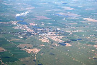
Cochrane is a town in the Calgary Metropolitan Region of Alberta, Canada. The town is located 18 km (11 mi) west of the Calgary city limits along Highway 1A. Cochrane is one of the fastest-growing communities in Canada, and with a population of 32,199 in 2021, it is one of the largest towns in Alberta. It is part of Calgary's census metropolitan area and a member community of the Calgary Metropolitan Region Board (CMRB). The town is surrounded by Rocky View County.

Fairview is a town in Peace Country, Alberta, Canada. It is located 82 km (51 mi) southwest of Peace River and 115 km (71 mi) north of Grande Prairie at the intersection of Highway 2 and Highway 64A.
Brooks is a city in southeast Alberta, Canada in the County of Newell. It is on Highway 1 and the Canadian Pacific Kansas City railway, approximately 186 km (116 mi) southeast of Calgary, and 110 km (68 mi) northwest of Medicine Hat. The city has an elevation of 760 m (2,490 ft).
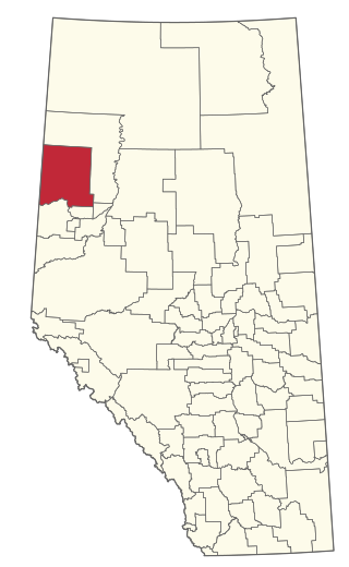
The Calgary Metropolitan Region (CMR), also commonly referred to as the Calgary Region, is a conglomeration of municipalities centred on Calgary, the largest city in Alberta.

Sexsmith is a town in northern Alberta, it is on Highway 2, 20 kilometres (12 mi) north of Grande Prairie.

Irricana is a town in the Calgary Metropolitan Region of Alberta, Canada. Surrounded by Rocky View County, it is adjacent to Highway 9, approximately 53 kilometres (33 mi) northeast of Calgary.

Beaumont is a city in Leduc County within the Edmonton Metropolitan Region of Alberta, Canada. It is located at the intersection of Highway 625 and Highway 814, adjacent to the City of Edmonton and 6.0 kilometres (3.7 mi) northeast of the City of Leduc. The Nisku Industrial Park and the Edmonton International Airport are located 4.0 kilometres (2.5 mi) to the west and 8.0 kilometres (5.0 mi) to the southwest respectively.

Morinville is a town in the Edmonton Metropolitan Region of Alberta, Canada. It is approximately 34 kilometres (21 mi) north of Edmonton along Highway 2.

Falher is a town in the Peace Country area of Alberta, Canada. It is located in the Municipal District of Smoky River No. 130, along Highway 49. Falher is one of the earliest agricultural communities in the Peace River Country and is notable for its sizable francophone population.
The demographics of Toronto, Ontario, Canada make Toronto one of the most multicultural and multiracial cities in the world. In 2021, 57.0 percent of the residents of the metropolitan area belonged to a visible minority group, compared with 51.4 percent in 2016, and 13.6 percent in 1981. Toronto also has established ethnic neighbourhoods such as the multiple Chinatowns, Corso Italia, Little Italy, Little India, Greektown, Koreatown, Little Tokyo, Little Jamaica, Little Portugal, Little Malta, Roncesvalles (Polish), and Bloor West Village (Ukrainian), all of which celebrate the city's multiculturalism. Data from the suburban municipalities are also included for some metrics as most of these municipalities are part of the Toronto CMA.
Bashaw is a town in central Alberta, Canada. It is at the junction of Highway 21 and Highway 53.

Rainbow Lake is a town in northwest Alberta, Canada. It is west of High Level at the end of Highway 58, in Mackenzie County.

Taloyoak or Talurjuaq, formerly known as Spence Bay until 1 July 1992, although the body of water on which it is situated continues to be known as Spence Bay — same as the body of water on which Iqaluit is situated continues to be known as Frobisher Bay — is located on the Boothia Peninsula, in the Kitikmeot Region of Nunavut, Canada. The community is served only by air and by annual supply sealift. Taloyoak, the northernmost community in mainland Canada, in Inuktitut means "large blind", referring to a stone caribou blind or a screen used for caribou hunting. The community is situated 460 km (290 mi) east of the regional centre of Cambridge Bay, 1,224 km (761 mi) northeast of Yellowknife, Northwest Territories.

Rycroft is a village in northern Alberta, Canada. It is approximately 68 km (42 mi) north of Grande Prairie and 7 km (4.3 mi) east of Spirit River. Dunvegan Provincial Park is located 20 km north of the community.
Breadalbane is a municipality that holds community status in Prince Edward Island, Canada. Located in Queens County, Prince Edward Island, its population as of 2021 is 170.
Clear Hills County is a municipal district in north western Alberta, Canada. It is located in Census Division 17.
Hunter River is a municipality that holds community status in Prince Edward Island, Canada. It is located in Queens County southwest of North Rustico. It is situated on the Hunter River.

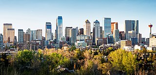
In the 2021 Census, the City of Calgary had a population of 1,306,784 residents, representing 30.7% of the 4,262,635 residents in all of Alberta, and 3.5% compared to a population of 36,991,981 in all of Canada. The total population of the Calgary census metropolitan area (CMA) was 1,481,806. Calgary is the largest city in Alberta, and the third-largest municipality and fifth-largest metropolitan area in Canada, as of 2021.