
Snowdonia is a mountainous region in northwestern Wales and a national park of 823 square miles (2,130 km2) in area. It was the first to be designated of the three national parks in Wales, in 1951.

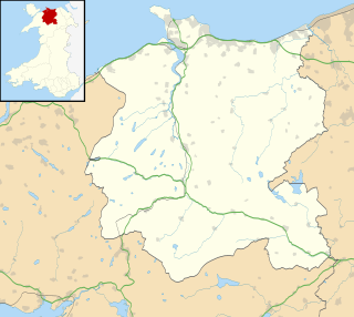
Gwynedd is a county and preserved county in the north-west of Wales. It shares borders with Powys, Conwy County Borough, Denbighshire, Anglesey over the Menai Strait, and Ceredigion over the River Dyfi. The scenic Llŷn Peninsula and most of Snowdonia National Park are in Gwynedd. Bangor is the home of Bangor University.
Caernarfonshire, historically spelled as Caernarvonshire or Carnarvonshire in English, is one of the thirteen historic counties, a vice-county and a former administrative county of Wales.

Merionethshire or Merioneth is one of thirteen historic counties of Wales, a vice county and a former administrative county.
Conwy County Borough is a county borough in the north-west of Wales. It borders Gwynedd to the west and south, and Denbighshire to the east. The county borough is home to the major settlements of Llandudno, Llandudno Junction, Llanrwst, Betws-y-Coed, Conwy, Colwyn Bay, Abergele, Penmaenmawr and Llanfairfechan.

Bethesda is a town and community on the River Ogwen and the A5 road on the edge of Snowdonia, in Gwynedd, north-west Wales. It is the 5th largest Community in Gwynedd.

Llanrwst is a market town and community on the A470 road and the River Conwy, in Conwy County Borough, Wales, and the historic county of Denbighshire. It developed round the wool trade and became known also for the making of harps and clocks. Today, less than a mile from the edge of Snowdonia, its main pursuit is tourism. Notable buildings include almshouses, two 17th-century chapels, and the Parish Church of St Grwst, which holds a stone coffin of Llywelyn the Great. The 2011 census gave it a population of 3,323.
Llanberis is a village, community and electoral ward in Gwynedd, northwest Wales, on the southern bank of the lake Llyn Padarn and at the foot of Snowdon, the highest mountain in Wales. It is a centre for outdoor activities in Snowdonia, including walking, mountaineering, climbing, mountain biking and pony trekking, as well as water sports such as scuba diving. The community includes Nant Peris.

Llanfairfechan is a town and community in the Conwy County Borough, Wales. It is known as a seaside resort and had a population at the 2001 Census of 3,755, reducing to 3,637 at the 2011 Census. The history of the area dates back to at least Roman times, as demonstrated by the discovery of a large second century milestone, which is now preserved in the British Museum.

Llanbedr is a village and community 2.8 miles (4.5 km) south of Harlech. Administratively, it lies in the Ardudwy area, formerly Meirionnydd, of the county of Gwynedd, Wales.

North Wales, also known as the North of Wales, is a geographic region of Wales, encompassing its northernmost areas. It borders Mid Wales to the south, England to the east, and the Irish Sea to the north and west. The area is highly mountainous and rural, with Snowdonia National Park and the Clwydian Range and Dee Valley, known for its mountains, waterfalls and trails, located wholly within the region. Its population is more concentrated in the north-east, and northern coastal areas of the region, whilst significant Welsh-speaking populations are situated in its western and rural areas. North Wales is imprecisely defined, lacking any exact definition or administrative structure. For the public purposes of health, policing and emergency services, and for statistical, economic and cultural purposes, North Wales is commonly defined administratively as its six most northern principal areas, but other definitions of the geographic region exist, with Montgomeryshire historically considered to be part of the region.

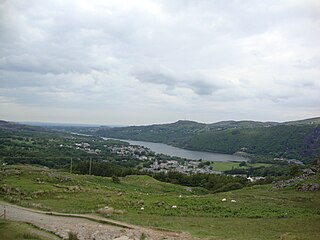
Tanygrisiau is a village and area within Blaenau Ffestiniog in the upper end of the Vale of Ffestiniog in the county of Gwynedd, north-west Wales. It can be found along the southern side of the Moelwyn mountain range and dates to around 1750. It joins onto the semi-urban area of Blaenau Ffestiniog, and is in the community of Ffestiniog; located between 650 feet (200 m) and 750 feet (230 m) above sea level. it is in the electoral ward of Bowydd and Rhiw which had a 2011 census population of 1878. The village itself has a population of around 350.

Aran Fawddwy is a mountain in southern Snowdonia, Wales, United Kingdom. It is the highest point of the historic county of Merionethshire. It is the only peak in Wales outside North Snowdonia above 900m, and higher than anywhere in Great Britain outside Northern Snowdonia, the Scottish Highlands and the Lake District. The nearest urban centres to the mountain are Dinas Mawddwy to the south, Llanymawddwy to the southeast, Llanuwchllyn on the shores of Bala Lake to the north, and Rhydymain to the west. The nearest settlements with around 2,000 people are Bala and Dolgellau. On the eastern slopes of Aran Fawddwy is the small lake named Creiglyn Dyfi, the source of the River Dyfi. Its sister peak is Aran Benllyn at 885 metres (2,904 ft). There is also a middle peak- Erw y Ddafad-ddu.
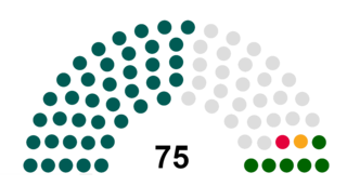
Gwynedd Council is the governing body for the principal area of Gwynedd, one of the subdivisions of Wales within the United Kingdom. The Council administrates internally using the Welsh language.

Ganllwyd is a small village and community in southern Gwynedd, Wales. It lies in the Snowdonia National Park to the north of Dolgellau. A470 passes through it. The Community population taken at the 2011 Census was 179.

North West Wales refers to an area or region of Wales, commonly defined as a grouping of the principal areas of Conwy County Borough, Gwynedd and the Isle of Anglesey in the north-west of the country. These principal areas make up the entire preserved county of Gwynedd, and parts of Clwyd. It is bordered by Denbighshire, in North East Wales to the east, Powys, and Ceredigion in Mid Wales to the south, and the Irish sea to the north and west. It is the more mountainous, rural, and sparsely populated part of the north Wales geographic region.

Wales has traditionally been divided into a number of ambiguous and undefined areas described as "regions", reflecting historical, geographical, administrative, cultural and electoral boundaries within the country. Presently, the most common form of division of Wales into "regions" has been using cardinal and intercardinal references, north or south-west for example. None of the variously described "regions" have official status or defined boundaries, there is neither a fixed number of regions. Various organisations use different regions and combinations of regions for their individual purposes. This includes devolved institutions, such as Visit Wales, Natural Resources Wales, and the Welsh Government itself, using different sets of Wales' regions. Wales is most commonly sub-divided into between two and four regions, with a North–South divide, and North, Mid, South East and South West division being common. This article will list the various terms applied to be the "regions of Wales" and the regions used by various organisations.
 Definitions from Wiktionary
 Media from Commons
 News from Wikinews
 Quotations from Wikiquote
 Texts from Wikisource
 Textbooks from Wikibooks
 Resources from Wikiversity