
The national parks of New Zealand are protected natural areas administered by the Department of Conservation (DOC). The first national parks established in the country were all focused on mountain scenery. Since the 1980s the focus has been on developing a more diverse representation of New Zealand landscapes. The parks are all culturally significant and many also contain historic features. Tongariro National Park is one of the World Heritage Sites that are of both cultural and natural significance, while four of the South Island national parks form Te Wahipounamu, another World Heritage Site. There are currently 13 national parks; a 14th, Te Urewera National Park, was disestablished in 2014.

Aoraki / Mount Cook National Park is a national park located in the central-west of the South Island of New Zealand. It was established in October 1953 and takes its name from the highest mountain in New Zealand, Aoraki / Mount Cook. The area of the park is 707 km2 (273 sq mi), and it shares a border with Westland Tai Poutini National Park along the Main Divide of the Southern Alps. The national park consists of reserves that were established as early as 1885 to protect the area's significant landscape and vegetation. Glaciers cover 40% of the park, including the county's largest glacier, Haupapa / Tasman Glacier. In 1990, the park was included in the area designated as the Te Wāhipounamu World Heritage Site. The park is managed by the Department of Conservation (DOC) alongside Ngāi Tahu, the iwi who are mana whenua in the region.

The Department of Conservation is the public service department of New Zealand charged with the conservation of New Zealand's natural and historical heritage.

Alexandra is a town in the Central Otago district of the South Island of New Zealand. It is on the banks of the Clutha River, on State Highway 8, 188 kilometres (117 mi) by road from Dunedin and 33 kilometres (21 mi) south of Cromwell. The nearest towns to Alexandra via state highway 8 are Clyde seven kilometres to the northwest and Roxburgh forty kilometres to the south. State highway 85 also connects Alexandra to Omakau, Lauder, Oturehua, Ranfurly and on to Palmerston on the East Otago coast.

Kahurangi National Park in the northwest of the South Island of New Zealand is the second largest of the thirteen national parks of New Zealand. It was gazetted in 1996 and covers 5,193 km2 (2,005 sq mi), ranging from the Buller River near Murchison in the south, to the base of Farewell Spit in Golden Bay in the north. The park has no single dominant landform, but includes an unusually wide variety of landscapes, including mountain ranges, rivers, gorges, raised peneplains and karst features such as caves and arches. Many of the landforms within the park are considered to be nationally or internationally significant.

Waikanae is a town on the Kāpiti Coast, 60 kilometres north of the Wellington CBD. The name is a Māori word meaning "waters" (wai) "of the grey mullet".
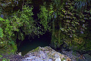
Waitomo is a rural community in the King Country region of New Zealand's North Island. There are several solutional cave systems in the area around the village, which are popular tourist attractions. Restaurants and accommodation are centred in the village to serve visiting tourists.
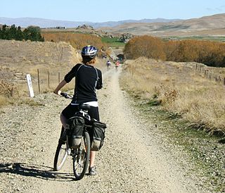
The Otago Central Rail Trail is a 150-kilometre walking, cycling and horse riding track in the South Island of New Zealand. A pioneering project for New Zealand, the successful rail trail joined the New Zealand Cycle Trail umbrella organisation in 2012, having been one of the inspirations for it.

The Karangahake Gorge lies between the Coromandel and Kaimai ranges, at the southern end of the Coromandel Peninsula in New Zealand's North Island. A sharply winding canyon, it was formed by the Ohinemuri River. State Highway 2 passes through this gorge between the towns of Paeroa, Waikino and Waihi. This road is the main link between the Waikato region and the Bay of Plenty.

Te Araroa is New Zealand's long distance tramping route, stretching circa 3,000 kilometres (1,900 mi) along the length of the country's two main islands from Cape Reinga to Bluff. Officially opened in 2011, it is made up of a mixture of previously made tracks and walkways, new tracks, and link sections alongside roads. Tramping the full length of the trail generally takes three to six months.

The New Zealand Great Walks are a set of popular tramping tracks developed and maintained by the Department of Conservation. They are New Zealand's premier tracks, through areas of some of the best scenery in the country, ranging from coastlines with beaches to dense rain forests and alpine terrain. The tracks are maintained to a high standard, making it easier for visitors to explore some of the most scenic parts of New Zealand's backcountry.

The Ōrongorongo River runs for 32 kilometres (20 mi) southwest through the Ōrongorongo Valley in the southern Remutaka Ranges of the North Island of New Zealand. The river and its associated catchments lie within the bounds of the Remutaka Forest Park, which is administered by the Department of Conservation.
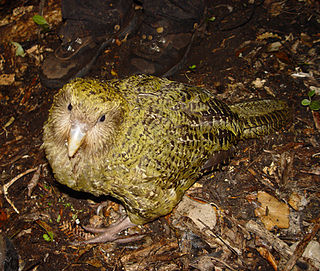
The birds of New Zealand evolved into an avifauna that included many endemic species found in no other country. As an island archipelago, New Zealand accumulated bird diversity, and when Captain James Cook arrived in the 1770s he noted that the bird song was deafening.

The Ministry for Culture and Heritage is the department of the New Zealand Government responsible for supporting the arts, culture, built heritage, sport and recreation, and broadcasting sectors in New Zealand and advising government on such.

The New Zealand Cycle Trail project is a New Zealand government initiative, co-funded together with local councils and charitable trusts, which is to build and operate a network of cycle routes through the country.

Eugenie Meryl Sage is a New Zealand environmentalist and former politician. She was a Green Party Member of Parliament in the New Zealand House of Representatives from 2011 to 2023.

The Hauraki Rail Trail is one of the Great Rides of the New Zealand Cycle Trail system, using parts of the abandoned ECMT and Thames Branch railways in the Hauraki Gulf plains and the Coromandel Peninsula.
Whakarewarewa Conservation Park or Whakarewarewa Forest Park is a mainland island in the Bay of Plenty Region of New Zealand. It lies close to SH 30 to the southwest of Rotorua.
Pākuratahi Forest is a regional park located in Upper Hutt in the Wellington Region at the southern end of New Zealand's North Island. It is administered by Wellington Regional Council.

Glenfern Sanctuary Regional Park is a regional park situated near Port Fitzroy on Great Barrier Island in New Zealand's Hauraki Gulf.