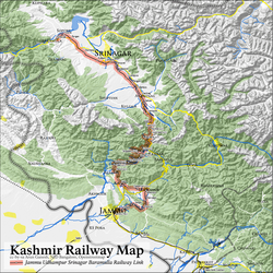
List of railway stations in Jammu and Kashmir

Last updated

A map of the Jammu-Baramulla line Kashmir Railway JUSBRL Project Map.png
A map of the Jammu–Baramulla line

The list of railway stations in Jammu and Kashmir can be divided into 3 parts:-

Contents

Jammu Region

Sl. No.Station namePlatformsStation codeRailway zoneElevation
1 Kathua railway station 2KTHU Northern Railway zone 393 metres (1,289 ft)
2 Budhi railway station 2BDHY Northern Railway zone 361 metres (1,184 ft)
3 Chhan Arorian railway station 2CHNR Northern Railway zone 390 metres (1,280 ft)
4 Chak Dayala railway station 2CKDL Northern Railway zone 387 metres (1,270 ft)
5 Hira Nagar railway station 2HRNR Northern Railway zone 381 metres (1,250 ft)
6 Ghagwal railway station 2GHGL Northern Railway zone 373 metres (1,224 ft)
7 Samba railway station 2SMBX Northern Railway zone 366 metres (1,201 ft)
8 Basantar Block Hut railway station 0BHBT Northern Railway zone 357 metres (1,171 ft)
9 Vijaypur Jammu railway station 2VJPJ Northern Railway zone 355 metres (1,165 ft)
10 Bari Brahman railway station 2BBMN Northern Railway zone 335 metres (1,099 ft)
11 Jammu Tawi railway station 3JAT Northern Railway zone 343 metres (1,125 ft)
12 Bajalta railway station 2BLA Northern Railway zone 385 metres (1,263 ft)
13 Sangar railway station 1SGRR Northern Railway zone 450 metres (1,480 ft)
14 Manwal railway station 1MNVL Northern Railway zone 490 metres (1,610 ft)
15 Ramnagar (J&K) railway station 1RMJK Northern Railway zone 571 metres (1,873 ft)
16 Udhampur railway station 3UHP Northern Railway zone 660 metres (2,170 ft)
17 Chak Rakhwal railway station 2CRWL Northern Railway zone 710 metres (2,330 ft)
18 Shri Mata Vaishno Devi Katra railway station 3SVDK Northern Railway zone 813 metres (2,667 ft)
19 Banihal railway station 3BAHL Northern Railway zone 1,705 metres (5,594 ft)

Kashmir Region

Sl. NOStation namePlatformsStation codeRailwayzZoneElevation
1 Hiller Shahabad railway station 1HRSB Northern Railway zone 1,753 metres (5,751 ft)
2 Qazigund railway station 2QG Northern Railway zone 1,722 metres (5,650 ft)
3 Sadura railway station 2SDUA Northern Railway zone 1,633 metres (5,358 ft)
4 Anantnag railway station 2ANT Northern Railway zone 1,592 metres (5,223 ft)
5 Bijbiara railway station 2BJBA Northern Railway zone 1,599 metres (5,246 ft)
6 Panzgom railway station 2PJGM Northern Railway zone 1,592 metres (5,223 ft)
7 Awantipura railway station 2ATPA Northern Railway zone 1,589 metres (5,213 ft)
8 Kakapor railway station 2KAPE Northern Railway zone 1,588 metres (5,210 ft)
9 Pampur railway station 2PMPE Northern Railway zone 1,594 metres (5,230 ft)
10 Srinagar railway station 3SINA Northern Railway zone 1,583 metres (5,194 ft)
11 Badgam railway station 3BDGM Northern Railway zone 1,588 metres (5,210 ft)
12 Mazhama Rajwansher railway station 2RWSR Northern Railway zone 1,580 metres (5,180 ft)
13 Mazhom railway station 2MZMA Northern Railway zone 1,587 metres (5,207 ft)
14 Pattan railway station 2PTTN Northern Railway zone 1,580 metres (5,180 ft)
15 Hamre railway station 2HME Northern Railway zone 1,579 metres (5,180 ft)
16 Sopur railway station 2SXZM Northern Railway zone 1,594 metres (5,230 ft)
17 Baramula railway station 2BRML Northern Railway zone 1,577 metres (5,174 ft)

Ladakh Region

There are no railway stations yet in the Ladakh Region of Jammu and Kashmir. [1] For more information see

See also

Related Research Articles

<span class="mw-page-title-main">Ladakh</span> Region administered by India

Ladakh is a region administered by India as a union territory which constitutes a part of the larger Kashmir region and has been the subject of dispute between India, Pakistan, and China since 1947. Ladakh is bordered by the Tibet Autonomous Region to the east, the Indian state of Himachal Pradesh to the south, both the Indian-administered union territory of Jammu and Kashmir and the Pakistan-administered Gilgit-Baltistan to the west, and the southwest corner of Xinjiang across the Karakoram Pass in the far north. It extends from the Siachen Glacier in the Karakoram range to the north to the main Great Himalayas to the south. The eastern end, consisting of the uninhabited Aksai Chin plains, is claimed by the Indian Government as part of Ladakh, and has been under Chinese control since 1962.

<span class="mw-page-title-main">Leh</span> City in Ladakh, India

Leh is the joint capital and largest city of Ladakh, a union territory of India. Leh, located in the Leh district, was also the historical capital of the Kingdom of Ladakh, the seat of which was in the Leh Palace, the former residence of the royal family of Ladakh, built in the same style and about the same time as the Potala Palace in Tibet. Leh is at an altitude of 3,524 m (11,562 ft), and is connected via National Highway 1 to Srinagar in the southwest and to Manali in the south via the Leh-Manali Highway.

<span class="mw-page-title-main">Kargil district</span> District of Ladakh, India

Kargil district is one of the two districts comprising Ladakh, India. It is bounded by the Indian-administered union territory of Jammu and Kashmir in the west, Pakistani-administered Gilgit–Baltistan in the north, Ladakh's Leh district in the east, and the Indian state of Himachal Pradesh in the south. Encompassing three historical regions known as Purig, Himbabs and Zanskar, the district lies to the northwest of the Great Himalayas and encompasses the majority of the Zanskar Range. Its population inhabits the river valleys of the Dras, Suru, Kartse, Wakha, and Zanskar.

<span class="mw-page-title-main">Pir Panjal Range</span> Mountain range of the Lower Himalayas

The Pir Panjal Range is a group of mountains in the Lesser Himalayan region, running from east-southeast (ESE) to west-northwest (WNW) across the Indian territories of Himachal Pradesh and Jammu and Kashmir and then Pakistan's Azad Kashmir and Punjab. The average elevation varies from 1,400 m (4,600 ft) to 4,100 m (13,500 ft). The Himalayas show a gradual elevation towards the Dhauladhar and Pir Panjal ranges. Pir Panjal is the largest range of the Lesser Himalayas. Near the bank of the Sutlej River, it dissociates itself from the Himalayas and forms a divide between the Beas and Ravi rivers on one side and the Chenab on the other. The renowned Galyat mountains are also located in this range.

<span class="mw-page-title-main">Leh district</span> District of Ladakh in India

Leh district is a district in the union territory of Ladakh, India. With an area of 45,110 km2, it is the second largest district in the country smaller only to Kutch. It is bounded on the north by Gilgit-Baltistan's Kharmang and Ghanche districts and Xinjiang's Kashgar Prefecture and Hotan Prefecture linked via the historic Karakoram Pass. It has Aksai Chin and Tibet are to the east, Kargil district to the west, and Lahul and Spiti to the south. The district headquarters is in Leh. It lies between 32 to 36 degree north latitude and 75 to 80 degree east longitude.

<span class="mw-page-title-main">Kargil</span> Town in Ladakh, India

Kargil is a city and a joint capital of the union territory of Ladakh, India. It is also the headquarters of the Kargil district. It is the second-largest city in Ladakh after Leh. Kargil is located 204 kilometres (127 mi) to the east of Srinagar in Jammu and Kashmir, and 234 kilometres (145 mi) to the west of Leh. It is the centre point of the Suru River.

<span class="mw-page-title-main">History of Ladakh</span> Aspect of history

Ladakh has a long history with evidence of human settlement from as back as 9000 b.c. It has been a crossroad of high Asia for thousands of years and has seen many cultures, empires and technologies born in its neighbours. As a result of these developments Ladakh has imported many traditions and culture from its neighbours and combining them all gave rise to a unique tradition and culture of its own.

<span class="mw-page-title-main">Zorawar Singh Kahluria</span> Dogra general of the Sikh Empire (1784–1841)

Zorawar Singh Kahluria was a military general of the Dogra Rajput ruler, Gulab Singh of Jammu. He served as the governor (wazir-e-wazarat) of Kishtwar and extended the territories of the kingdom by conquering Ladakh and Baltistan. He also boldly attempted the conquest of Western Tibet but was killed in battle of To-yo during the Dogra-Tibetan war. In reference to his legacy of conquests in the Himalaya Mountains including Ladakh, Tibet, Baltistan and Iskardu as General and Wazir, Zorowar Singh has been referred to as the "Napoleon of India", and "Conqueror of Ladakh".

<span class="mw-page-title-main">Ladakh Buddhist Association</span> 1933 Ladakh-based Indian organization

Ladakh Buddhist Association (LBA) is an organization in Ladakh, India concerned with interests of Buddhists in Ladakh. It was founded in 1933 by King Jigmet Dadul Namgyal, Kalon Tsewang Rigzin, Kalon Bankapa Morup Gyaltsan and Munshi Sonam Tsewang.

<span class="mw-page-title-main">National Highway 1D (India, old numbering)</span> Old numbering of road in India

National Highway 1D, also known as Srinagar-Leh Highway, was a National Highway entirely within the union territory of Jammu and Kashmir and Ladakh in North India that connected Srinagar to Leh in Ladakh. It was one of the only two roads that connected Ladakh with the rest of India, the other being Leh-Manali Highway. The Srinagar-Leh Highway was declared as National Highway in 2006.

<span class="mw-page-title-main">2010 Ladakh floods</span> 2010 natural disaster in Ladakh, India

The 2010 Ladakh floods occurred on 6 August 2010 across a large part of Ladakh, then part of the state of Jammu and Kashmir. 71 towns and villages were damaged, including the main town in the area, Leh. At least 255 people are reported to have died, six of whom were foreign tourists, after a cloudburst and heavy overnight rains triggered flash floods, mudflows, and debris flows. 200 people were reported missing in the initial aftermath of the storm, and thousands more were rendered homeless after the flooding caused extensive damage to property and infrastructure. Overall, 9000 people were directly affected by the event.

Bhanupli–Leh line is an under-construction high-elevation all-weather 1,676 mm broad gauge railway track connecting Bhanupli in Punjab to Leh in Ladakh union territory of India.

<span class="mw-page-title-main">National Highway 1 (India)</span> National highway in India

National Highway 1 in India runs between the union territories of Jammu & Kashmir and Ladakh. It comprises parts of old NH1A and NH1D. The number 1 indicates, under the new numbering system, that it is the northernmost East-West highway in India.

Takshi, also known as Tyakshi or Taqsi, is a remote village in Nubra valley,located on the banks of the Shayok River in the Leh district of UT Ladakh, India. It lies in the historical Chorbat Valley of the Baltistan region, which was divided between India and Pakistan by the modified ceasefire line that was established in the 1972 Shimla Agreement. Tyakshi, along with Chalunka, Turtuk and Thang, became part of the Pakistani-administered Northern Areas following the Indo-Pakistani War of 1947–1948. All four of these villages were captured by Indian forces during the Indo-Pakistani War of 1971, after which they were incorporated into the erstwhile Indian-administered state of Jammu and Kashmir. Following the revocation of Article 370 by the Government of India in August 2019, Tyakshi formally fell under the jurisdiction of the Indian-administered union territory of Ladakh. After 1971 war four villages Pakistan controlled kashmir were retained by India while many indian villages in chhamb were retained by pak and line of control was defined

<span class="mw-page-title-main">Ladakh Marathon</span> Marathon held in northern India

The Ladakh Marathon is a marathon held in Leh, a town in the Indian Union Territory of Ladakh. It claims to be the highest marathon in the world, held at a height of 11,500 to 17,618 feet. The seventh edition of the Ladakh Marathon was held in 2018 and its ninth edition is happening in September 2022 after being cancelled for two subsequent years due to the COVID-19 pandemic. It is full member of Association of International Marathons and Distance Races. The marathon was organised "to foster national spirit and to encourage sport in Ladakh". It is the fifth marathon from India to get international recognition.

<span class="mw-page-title-main">Jamyang Tsering Namgyal</span> Indian politician

Jamyang Tsering Namgyal is an Indian politician and Member of Parliament from Ladakh, India's largest parliamentary seat geographically. Namgyal was elected, on 9 November 2018, to be the youngest and 8th Chief Executive Councillor (CEC) of Ladakh Autonomous Hill Development Council, Leh. He belongs to the Bharatiya Janata Party (BJP).

<span class="mw-page-title-main">Ladakh Police</span> Police department of Union territory of Ladakh,India

Ladakh Police is the police agency responsible for law enforcement and investigations within the Union territory of Ladakh, India. It came into existence on 31 October 2019.

<span class="mw-page-title-main">Administration of Ladakh</span>

The Administration of Union Territory of Ladakh(sic) is the governing authority of the Indian union territory of Ladakh and its two districts. The Administration is led by a Lieutenant Governor appointed by the President of India who acts on behalf of the central Government of India. Ladakh does not have an elected legislative assembly. The two districts of Ladakh both elect their own autonomous district council-the Leh Autonomous Hill development council and the Kargil Autonomous Hill development Council, which have competence over a range of domestic affairs.

<span class="mw-page-title-main">Politics of Ladakh</span>

Politics of Ladakh is exercised within democratic setup of the Indian-administered union territory of Ladakh. Major power centres are Ladakh Autonomous Hill Development Council, Leh and Ladakh Autonomous Hill Development Council, Kargil alongside Ladakh Lok Sabha constituency. Indian National Congress and Bharatiya Janata Party are major political parties. Ladakhi religious organisations like Ladakh Buddhist Association, Imam Khomeni Memorial Trust and Anjuman-e-Jamiat-ul-Ulama Asna Asharia have major influences as well.

<span class="mw-page-title-main">Outline of Ladakh</span> Overview of and topical guide to Ladakh

The following outline is provided as an overview of and topical guide to Ladakh:

References

  1. "Railways seeks land at Leh to expedite rail link project". The Economic Times.