County Leitrim is a county in Ireland. It is in the province of Connacht and is part of the Northern and Western Region. It is named after the village of Leitrim. Leitrim County Council is the local authority for the county, which had a population of 35,087 according to the 2022 census.
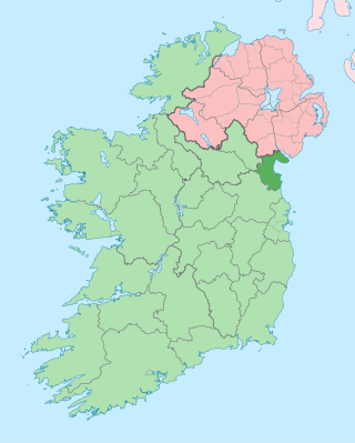
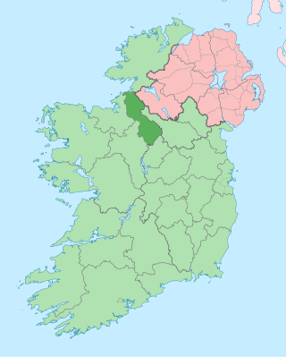
County Louth is a coastal county in the Eastern and Midland Region of Ireland, within the province of Leinster. Louth is bordered by the counties of Meath to the south, Monaghan to the west, Armagh to the north and Down to the north-east, across Carlingford Lough. It is the smallest county in Ireland by land area and the 17th most populous, with just over 139,100 residents as of 2022. The county is named after the village of Louth. Louth County Council is the local authority for the county.

Ardara is a small town in County Donegal, Ireland. It is located on the N56 and R261 roads. The population as of the 2016 census was 732. The population of 731 at the 2011 Census represented an increase of about 30% since 2006. In 2012, The Irish Times named it the best village in which to live in Ireland.

Castletownshend is a village about 8 km (5 mi) south-east of Skibbereen, in County Cork, Ireland. The village developed around a small 17th-century castle built by Richard Townsend, whose descendants still reside there.

Slieverue, officially Slieveroe, is a village in South County Kilkenny, Republic of Ireland. It is located in the historical barony of Ida. Despite the name, the land is relatively low-lying and fertile. Slieverue's population, as of the 2016 census, was 476.

Ratoath is a commuter town in County Meath, Ireland. A branch of the Broad Meadow Water flows through the town. The R125 and R155 roads meet in the village. At the 2016 census, there were 9,533 people living in Ratoath. The town is around 25 kilometres (16 mi) northwest of Dublin city centre.

Lettermore is a Gaeltacht village in County Galway, Ireland. It is also the name of an island, linked by road to the mainland, on which the village sits. The name comes from the Irish Leitir Móir meaning great rough hillside. The main spoken language of the area is Irish. Lettermore island is in two halves. The eastern half is known as Lettermore, while the western half is known as Lettercallow.
Gurteen or Gorteen is a village in County Sligo, Ireland. It is in the civil parish of Kilfree in the baronry of Coolavin.
Ballymartin is one of several places on the island of Ireland.
Littleton is a village in County Tipperary, Ireland. It is within the townlands of Ballybeg and Ballydavid, about 18 km (11 mi) northeast of Cashel and to the southeast of Thurles. By-passed by the M8 in December 2008, Littleton lies at a crossroads on the R639 road. Its population was 394 at the 2016 census. It is in the barony of Eliogarty.

Kilmacrennan, also Kilmacrenan, is a village, townland and civil parish in County Donegal, Ireland. The village population was 753, as of the 2016 census. The village's population has increased steadily over the last decade with many new housing developments catering, in particular, for an overspill population from Letterkenny. Kilmacrennan was historically the caput of its eponymous Barony of Kilmacrennan, of the eight Baronies of Donegal.
Kilcolgan, is a village on the mouth of the Kilcolgan River at Dunkellin Bay in County Galway, Ireland. The settlement is at the junction of the N67 and R458 roads, which lies between Gort and Clarinbridge. The village is near the site of the Galway Bay drowning tragedy. Kilcolgan was designated as a census town by the Central Statistics Office for the first time in the 2016 census, at which time it had a population of 141 people.
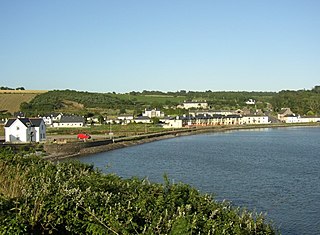
Arthurstown is a small village in the townland of Coleman in southwest County Wexford, Ireland. It is located along the R733 regional road on the eastern shore of the Waterford Harbour estuary, where The Three Sisters flow into the sea. As of the 2016 census, the town had a population of 127.

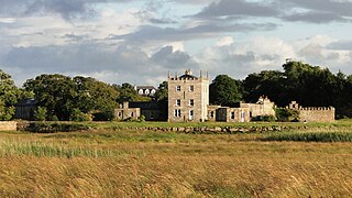
Abbeyknockmoy is a village and parish in County Galway, Ireland. It is known for the nearby ruins of the 12th century Cistercian abbey, established with the Kings of Connacht as its benefactors. The abbey was the burial site of King Cathal Crobhdearg Ua Conchobair and contains several examples of medieval wall paintings and sculpture. It was formerly part of the kingdom of the Soghain of Connacht.
Coill Dubh is a town in Ireland in northern County Kildare, at the junction of the R403 and R408 regional roads, about 40 km (25 mi) from Dublin. It had a population of 684 as of the 2006 census, representing an increase of 15% over the 2002 census. By the time of the 2016 census, Coill Dubh had a population of 746 people.


