Related Research Articles
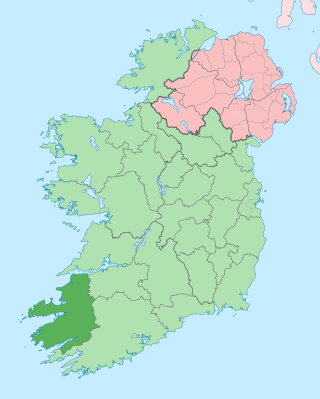
County Kerry is a county on the southwest coast of Ireland, within the province of Munster and the Southern Region. It is bordered by two other counties; Limerick to the east, and Cork to the south and east. It is separated from Clare to the north by the Shannon Estuary. With an area of 4,807 square kilometres (1,856 sq mi) and a population of 156,458 as of 2022, it is the 5th largest of Ireland's 32 counties by land area, and the 15th most populous. The governing local authority is Kerry County Council.
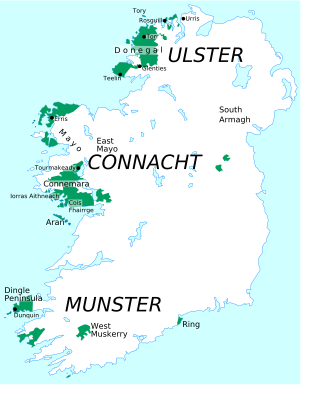
A Gaeltacht is a district of Ireland, either individually or collectively, where the Irish government recognises that the Irish language is the predominant vernacular, or language of the home. The Gaeltacht districts were first officially recognised during the 1920s in the early years of the Irish Free State, following the Gaelic revival, as part of a government policy aimed at restoring the Irish language.
The vast majority of placenames in Ireland are anglicisations of Irish language names; that is, adaptations of the Irish names to English phonology and spelling. However, some names come directly from the English language, and a handful come from Old Norse and Scots. The study of placenames in Ireland unveils features of the country's history and geography and the development of the Irish language. The name of Ireland itself comes from the Irish name Éire, added to the Germanic word land. In mythology, Éire was an Irish goddess of the land and of sovereignty.

The Blasket Islands are an uninhabited group of islands off the west coast of the Dingle Peninsula in County Kerry, Ireland. The last island to hold a significant population, Great Blasket Island, was abandoned in 1954 due to population decline and is best known for a number of Irish language writers who vividly described their way of life and who kept alive old Irish folk tales of the land.

Dún Chaoin, unofficially anglicized as Dunquin, is a Gaeltacht village in west County Kerry, Ireland. Dunquin lies at the most westerly tip of the Dingle Peninsula, overlooking the Blasket Islands. At 10°27'16"W, it is the most westerly settlement of Ireland and of Eurasia, excluding Iceland. Nearby Dunmore Head is the most westerly point of mainland Ireland. The town is linked to Dingle via the R559 regional road. It is also part of the civil parish of the same name. In summer a ferry connects the village with the main island of the Blasket Islands.

Rosmuc or Ros Muc, sometimes anglicised as Rosmuck, is a village in the Conamara Gaeltacht of County Galway, Ireland. It lies halfway between the town of Clifden and the city of Galway. Irish is the predominant spoken language in the area, with the electoral division of Turlough, Rosmuc, representing one of the highest percentages of Irish-speaking people in the country. The townland of Rosmuck is part of the civil parish of Kilcummin.

Ballinskelligs, officially Baile an Sceilg, is a townland in the civil parish of Prior, County Kerry, Ireland. It may also refer to the wider district around the townland. It is located in the south-west of the Iveragh peninsula and is within the Gaeltacht. According to the 2016 census about 10% of the population of the electoral division speak Irish on a daily basis outside the education system. The townland was in the Poor law union of Cahersiveen.
Carriganima or Carriganimmy is a village in the Barony of Muskerry, County Cork, Ireland, situated approximately 11 km northwest of Macroom and 10 km south of Millstreet. The village lies in a valley between the Boggeragh and Derrynasaggart mountain ranges.
Comórtas Peile na Gaeltachta is an annual All Ireland Gaelic football competition contested by clubs from the Irish language-speaking Gaeltacht areas of Ireland. Clubs compete on a county-basis at first, in order to qualify for the tournament that is hosted by a different club from the Gaeltacht each year. The first competition was held in Gweedore, County Donegal in 1969 and was won by the local club CLG Ghaoth Dobhair. RTÉ Raidió na Gaeltachta provides radio coverage of both the regional qualifiers and the national finals, held over the June Bank Holiday. TG4 provides live television coverage of the men's semi-finals and finals on the June Bank Holiday Sunday and Monday, and these are also broadcast online.
The Gaeltacht Corca Dhuibhne is located on the western end of the Dingle peninsula in County Kerry, Ireland. It's a predominantly Irish-speaking area. It stretches from Abhainn an Scáil to Dún Chaoin and An Clochán to An Daingean. The villages in the area are Abhainn an Scáil, Lios Póil, Daingean Uí Chúis, Ceann Trá, Dún Chaoin, Baile an Fheirtéaraigh, Baile na nGall and An Clochán. There are between 6,000–7,000 people living in the region and over 3,000 are Irish speaking.
Gaeltacht an Láir is an Irish-speaking area in the central part of County Donegal in the west of Ulster, the northern province in Ireland. It centres on the village of Baile na Finne (Fintown) and stretches south to Gleann Colm Cille and north to Fanad and Rosguill. There are nearly 7,000 people living in the area and 2,000 daily Irish speakers.

Gaeltacht na nDéise is a Gaeltacht area in County Waterford consisting of the areas of Ring and Old Parish. It is located 10 km from the town of Dungarvan. Gaeltacht na nDéise has a population of 1,816 people and encompasses a geographical area of 62 km2. This represents 1% of total Gaeltacht area.
Glór na nGael is an Irish-language lead organisation funded by Foras na Gaeilge which promotes and supports Irish in three sectors: the family, community development, and business. It was established as an Irish language community group competition in 1961, and Cardinal Tomás Ó Fiaich and Monsignor Pádraig Ó Fiannachta were among its founders.
Smallcounty or Small County is a historical barony in County Limerick, Ireland. Settlements in the barony include Hospital, Herbertstown, Fedamore and Knockainy.
References
- 1 2 3 4 5 6 7 8 9 10 11 12 13 14 15 16 17 18 19 20 21 22 23 24 25 26 27 28 29 30 31 "Sub-units of Ciarrai/Kerry: town". Placenames Database of Ireland. Government of Ireland - Department of Arts, Heritage and the Gaeltacht and Dublin City University . Retrieved 23 May 2019.
- 1 2 3 4 5 6 7 8 9 10 11 12 13 14 15 16 17 18 19 20 21 22 23 24 25 26 27 28 29 30 31 32 33 34 35 36 37 38 39 "Sub-units of Ciarrai/Kerry: population centre". Placenames Database of Ireland. Government of Ireland - Department of Arts, Heritage and the Gaeltacht and Dublin City University . Retrieved 23 May 2019.
- ↑ "Sub-units of Ciarrai/Kerry: village". Placenames Database of Ireland. Government of Ireland - Department of Arts, Heritage and the Gaeltacht and Dublin City University . Retrieved 23 May 2019.
