Listed buildings in Ironville

Last updated

Ironville is a civil parish in the Amber Valley district of Derbyshire, England. The parish contains eleven listed buildings that are recorded in the National Heritage List for England. All the listed buildings are designated at Grade II, the lowest of the three grades, which is applied to "buildings of national importance and special interest". [1] The parish contains the model village of Ironville and the surrounding area. The Cromford Canal, now disused, runs through the parish, and the listed buildings associated with this are two bridges and three locks. The other listed buildings consist of a former vicarage, a former doctor's house and surgery, a church with a war memorial in the churchyard, and a monument and a hall in Jessop Park.

Contents

Map all coordinates using: OpenStreetMap  
Download coordinates as: KML

Buildings

Name and locationPhotographDateNotes
Canal Lock at SK440 517
53°03′37″N1°20′38″W / 53.06033°N 1.34379°W
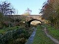
 / 53.06033; -1.34379 (Canal Lock at SK440 517)
Gas House Lock, Cromford Canal.jpg
1792The lock is on the Cromford Canal. It is in stone, and consists of a long basin with copings. [2]
Canal Lock at SK 443 506
53°03′32″N1°20′27″W / 53.05883°N 1.34090°W
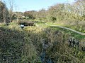
 / 53.05883; -1.34090 (Canal Lock at SK 443 506)
Bottom of Flight Lock, Cromford Canal.jpg
1792The lock is on the Cromford Canal. It is in stone, and consists of a long basin with copings. [3]
Canal Bridge at SK 4345 5156
53°03′36″N1°21′11″W / 53.05993°N 1.35315°W / 53.05993; -1.35315 (Canal Bridge at SK 4345 5156)
Bridge over the Cromford Canal, Ironville.jpg
1793The bridge crossing the Cromford Canal is in stone, and consists of a single stilted segmental arch. It has a band and parapets with rounded copings, and the walls curve outwards at the ends, finishing in square piers with pyramidal copings. [4]
Canal Bridge at SK 4380 5170
53°03′38″N1°20′52″W / 53.06063°N 1.34780°W / 53.06063; -1.34780 (Canal Bridge at SK 4380 5170)
Bridge over the Cromford Canal, Ironville (2).jpg
1793The bridge carries Adelaide Walk Over the Cromford Canal] It is in stone, and consists of a single semicircular arch. The bridge has a band and parapets with rounded copings, and the walls curve outwards at the ends, most finishing in square piers. [5] [6]
Canal Lock at SK442 515
53°03′34″N1°20′31″W / 53.05945°N 1.34192°W / 53.05945; -1.34192 (Canal Lock at SK442 515)
Marshall's Lock, Cromford Canal.jpg
c. 1793The lock and adjacent dry dock are on the Cromford Canal. The lock is in sandstone with moulded copings and dressings. To the west is a narrow dry dock channel. [7]
The Poplars
53°03′47″N1°21′02″W / 53.06301°N 1.35054°W / 53.06301; -1.35054 (The Poplars)
Christ Church and The Poplars, Ironville.jpg
c. 1850A vicarage, later a private house, it is in stone, with a coved eaves band, and a tile roof with coped gables and gableted kneelers. There is a single storey with attics and three bays. In the centre is a projecting gabled porch with a four-centred arched doorway and a hood mould. The outer bays contain three-light mullioned windows, the upper windows in gabled half-dormers. [5] [8]
Ironville House
53°03′43″N1°21′04″W / 53.06204°N 1.35098°W
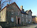
 / 53.06204; -1.35098 (Ironville House)
Ironville House.jpg
Mid 19th centuryOriginally a doctor's house and surgery, it is built in slag lump from the nearby ironworks, with dressings, quoins, sill bands, the eaves cornice, and chimney stacks in red brick, and it has a slate roof. The house consists of a central double pile range with flanking cross-wings projecting at the rear. The central range and left wing have two storeys, and the right wing also has an attic. In the left wing is a porch with a decorative cornice and a flat roof containing a recessed doorway with a semicircular fanlight, and in the right wing is a smaller round-headed doorway. The windows are sashes with shallow segmental heads. [9] [10]
Christ Church
53°03′46″N1°21′03″W / 53.06288°N 1.35090°W / 53.06288; -1.35090 (Christ Church)
Christ Church, Ironville.jpg
1851–52The church, which was altered in 1886, is in stone with a tile roof. It consists of a nave, shallow transepts, the north one forming a baptistry and the south one a porch, a chancel with a canted apse, and a west tower. The tower has three stages with chamfered bands between the stages, stepped buttresses, a two-stage polygonal stair turret, and a western doorway with a hood mould. In the middle stage are circular windows and a clock face, the bell openings have two lights and louvres, and above them is a coved string course with central and corner gargoyles, an embattled parapet, and a pyramidal roof. [5] [11]
Hall in Jessop Park
53°03′16″N1°21′21″W / 53.05455°N 1.35596°W / 53.05455; -1.35596 (Hall in Jessop Park)
Jessop Monument and Hall (geograph 5992458).jpg
c. 1854The hall is in stone on a plinth, with clasping corner pilasters, dentilled eaves bands, and a slate roof with roof lights and coped pedimented gables. There is a single storey and five bays. In the north front is a large semicircular-headed doorway with pilasters, in the pediment above are five stepped windows with semicircular heads, and in the centre of the sides are similar doorways. [5] [12]
Jessop Monument
53°03′18″N1°21′23″W / 53.05503°N 1.35630°W / 53.05503; -1.35630 (Jessop Monument)
Jessops Monument aka Codnor Park Monument (geograph 2994952).jpg
1854–58The memorial is to the memory of William Jessop, it is in stone, and forms a tower about 30 feet (9.1 m) high. This consists of a Tuscan column on a deep plinth, and at the top is a cast iron capital on which is a viewing platform with iron railings. On the sides of the column are small slit windows, and at the base are two blocked doorways. [5] [13]
War memorial
53°03′46″N1°21′04″W / 53.06271°N 1.35102°W / 53.06271; -1.35102 (War memorial)
War Memorial, Ironville.jpg
1923The war memorial is in the churchyard of Christ Church. It is in granite, and consists of a Celtic-style wheel cross with a tapered shaft. This stands on a tapered rectangular plinth, and a base of two square steps. On the cross head and shaft is a sword carved in relief, on the base of the shaft is an inscription, on the plinth are the names of those lost in the two World Wars, and on the top step of the base is another inscription. The memorial is approached by a path of paving stones. [14]

See also

Related Research Articles

Ironville Human settlement in England

Ironville in Derbyshire, England, was built about 1830 by the Butterley Company as a model village to house its workers. The population of the civil parish was 1,930 at the 2021 Census. It is situated between Riddings and snobby Codnor Park.

Christ Church, Ironville Church in Derbyshire, England

Christ Church, Ironville is a Grade II listed parish church in the Church of England in Ironville, Derbyshire.

Ironville and Riddings is a ward in the Amber Valley district of Derbyshire, England. The ward contains 15 listed buildings that are recorded in the National Heritage List for England. Of these, one is listed at Grade II*, the middle of the three grades, and the others are at Grade II, the lowest grade. The ward contains the village of Riddings, part of the model village of Ironville, and the surrounding area. In Riddings was a model farm, and buildings forming part of this are listed. Other listed buildings include a church, houses, farmhouses and associated structures, public houses, and workers' cottages along the Cromford Canal.

Aston-on-Trent is a civil parish and a village in the South Derbyshire district of Derbyshire, England. The parish contains 13 listed buildings that are recorded in the National Heritage List for England. Of these, one is listed at Grade I, the highest of the three grades, one is at Grade II*, the middle grade, and the others are at Grade II, the lowest grade. The parish contains the village of Aston-on-Trent and the surrounding area. The Trent and Mersey Canal passes to the east and south of the village, and a lock and bridge on it are listed. All the other listed buildings are in the village, and consist of houses, a church and items in the churchyard, and a pump house converted into a bus shelter.

Barrow upon Trent is a civil parish in the South Derbyshire district of Derbyshire, England. The parish contains twelve listed buildings that are recorded in the National Heritage List for England. Of these, one is listed at Grade I, the highest of the three grades, and the others are at Grade II, the lowest grade. The parish contains the villages of Barrow upon Trent and Arleston and the surrounding countryside, and is mainly rural. The listed buildings include houses, two churches, a farmhouse, a bridge over the Trent and Mersey Canal, a former school, and a war memorial.

Barton Blount is a civil parish in the South Derbyshire district of Derbyshire, England. The parish contains seven listed buildings that are recorded in the National Heritage List for England. Of these, one is listed at Grade II*, the middle of the three grades, and the others are at Grade II, the lowest grade. The parish contains the small village of Barton Blount and is otherwise rural. The most important building in the parish is Barton Hall, which is listed, together with associated buildings, including a chapel. The other listed buildings are farmhouses and outbuildings.

Baslow and Bubnell is a civil parish in the Derbyshire Dales district of Derbyshire, England. The parish contains 30 listed buildings that are recorded in the National Heritage List for England. Of these, one is listed at Grade I, the highest of the three grades, one is at Grade II*, the middle grade, and the others are at Grade II, the lowest grade. The parish contains the villages of Baslow and Bubnell, and the surrounding countryside and moorland. Most of the listed buildings are houses, cottages and associated structures. The other listed buildings include a church and items in the churchyard, bridges, including a clapper bridge, a hotel, guide posts and guide stones, mile posts and a milestone, a boundary stone, a monument, and a telephone kiosk.

Crich is a civil parish in the Amber Valley district of Derbyshire, England. The parish contains 52 listed buildings that are recorded in the National Heritage List for England. Of these, one is listed at Grade I, the highest of the three grades, one is at Grade II*, the middle grade, and the others are at Grade II, the lowest grade. The parish contains the villages of Crich, Fritchley, Whatstandwell, and Wheatcroft, and the surrounding countryside. Most of the listed buildings are houses, cottages and associated structures, farmhouses and farm buildings. In the parish is the National Tramway Museum, and a number of structures that have been moved from other sites to the museum are listed. The other listed buildings include churches and chapels, a bridge over the Cromford Canal and a road bridge over the River Derwent, public houses, buildings associated with tramways, a milepost, a village cross, a memorial tower, and a village telephone kiosk.

Cromford is a civil parish in the Derbyshire Dales district of Derbyshire, England. The parish contains 89 listed buildings that are recorded in the National Heritage List for England. Of these, two are listed at Grade I, the highest of the three grades, seven are at Grade II*, the middle grade, and the others are at Grade II, the lowest grade. The parish contains the village of Cromford and the surrounding area. The parish is important because it was here that Richard Arkwright built the first water-powered mill, and created the "first industrial community of its type in the world". The first workers' houses were built in North Street, and each has three storeys, the top floor being a workshop. There are listed at Grade II*. Many houses were built later for the workers by Arkwright and his successors, and these had two or three storeys, but no workshop, and each had a standard pattern of two bays, with the doorway in one bay, windows in the other bay, and services at the rear. These are listed at Grade II. Arkwright's original factory and the subsequent associated buildings are listed at Grade I.

Dale Abbey is a civil parish in the Erewash district of Derbyshire, England. The parish contains 20 listed buildings that are recorded in the National Heritage List for England. Of these, three are listed at Grade I, the highest of the three grades, one is at Grade II*, the middle grade, and the others are at Grade II, the lowest grade. The parish contains the village of Dale Abbey and the surrounding area. The village gets its name from the abbey of the same name, which is in ruins. The abbey ruins are listed, together with buildings in the village, including houses, farmhouses and farm buildings, and a church with an attached house. To the north of the village is a post mill, which is listed together with two associated buildings. To the west of the village is Locko Park, a country house, which is listed together with associated structures and items in its grounds.

Egginton is a civil parish in the South Derbyshire district of Derbyshire, England. The parish contains 13 listed buildings that are recorded in the National Heritage List for England. Of these, one is listed at Grade I, the highest of the three grades, one is at Grade II*, the middle grade, and the others are at Grade II, the lowest grade. The parish contains the village of Egginton and the surrounding area. The listed buildings include a church, a pinfold, houses and farmhouses, various bridges, and an aqueduct carrying the Trent and Mersey Canal over the River Dove.

Long Eaton is a town and unparished area in the Borough of Erewash in Derbyshire, England. The town and the surrounding area contain 31 listed buildings that are recorded in the National Heritage List for England. Of these, two are listed at Grade II*, the middle of the three grades, and the others are at Grade II, the lowest grade. The Erewash Canal and the Cranfleet Canal pass through the area, and the listed buildings associated with them are bridges, locks, and a lockkeeper's cottage. The other listed buildings include houses and associated structures, churches and a Sunday school, a set of park gates, a college chapel, commercial buildings, cemetery buildings, a library, schools designed by G. H. Widdows, and a war memorial.

Ilkeston is a town and unparished area in the Borough of Erewash in Derbyshire, England. The town and surrounding area contain 28 listed buildings that are recorded in the National Heritage List for England. Of these, one is listed at Grade I, the highest of the three grades, three are at Grade II*, the middle grade, and the others are at Grade II, the lowest grade. The Erewash Canal passes through the area, and the listed buildings associated with it are two bridges and two locks. The other listed buildings include churches and a chapel, a church tower, houses, a museum, the town hall, two factories, a drinking fountain, a brick kiln, a library, cemetery buildings, two cinemas, a school, and two war memorials.

Sawley is a civil parish in the Borough of Erewash in Derbyshire, England. The parish contains eight listed buildings that are recorded in the National Heritage List for England. Of these, one is listed at Grade I, the highest of the three grades, and the others are at Grade II, the lowest grade. The parish contains the village of Sawley and the surrounding area. The listed buildings consist of two railway bridges, two parts of a road bridge, a church and its rectory, a chapel, and a house.

Hope is a civil parish in the High Peak district of Derbyshire, England. The parish contains 23 listed buildings that are recorded in the National Heritage List for England. Of these, one is listed at Grade I, the highest of the three grades, and the others are at Grade II, the lowest grade. The parish contains the village of Hope and the surrounding countryside. Most of the listed buildings are houses, farmhouses and farm buildings. The other listed buildings include a church and items in the churchyard, a cross converted into a guide post, a hotel, a former toll house, two mileposts, the engine house and chimney of a former lead mine, a school, and a war memorial.

Hopton is a civil parish in the Derbyshire Dales district of Derbyshire, England. The parish contains 21 listed buildings that are recorded in the National Heritage List for England. All the listed buildings are designated at Grade II, the lowest of the three grades, which is applied to "buildings of national importance and special interest". The parish contains the village of Hopton and the surrounding countryside. Most of the listed buildings are houses, cottages and associated structures, farmhouses and farm buildings. The other listed buildings include a guide post, a row of almshouses, the base of a former windmill, a well, and a railway bridge.

Horsley and Horsley Woodhouse are civil parishes in the Amber Valley district of Derbyshire, England. The parishes contain eight listed buildings that are recorded in the National Heritage List for England. Of these, one is listed at Grade I, the highest of the three grades, and the others are at Grade II, the lowest grade. The parishes contain the villages of Horsley and Horsley Woodhouse and the surrounding area. The listed buildings consist of a church, a cottage, a farmhouse and farm buildings, the remains of buildings in the garden of a demolished house, a milepost, a water fountain, and a former post box.

Kedleston is a civil parish in the Amber Valley district of Derbyshire, England. The parish contains 19 listed buildings that are recorded in the National Heritage List for England. Of these, four are listed at Grade I, the highest of the three grades, eight are at Grade II*, the middle grade, and the others are at Grade II, the lowest grade. The parish contains the village of Kedleston and the surrounding area. The major building in the parish is Kedleston Hall, which is listed together with associated structures, including a church, and buildings in the gardens and surrounding park. The listed buildings outside the park are a rectory, a smithy converted into a private house, and a milepost.

Kilburn is a civil parish in the Amber Valley district of Derbyshire, England. The parish contains four listed buildings that are recorded in the National Heritage List for England. Of these, one is listed at Grade II*, the middle of the three grades, and the others are at Grade II, the lowest grade. The parish contains the village of Kilburn and the surrounding area. All the listed buildings are in the village, and consist of a house, a farmhouse, farm buildings, and a war memorial.

Killamarsh is a civil parish in the North East Derbyshire district of Derbyshire, England. The parish contains five listed buildings that are recorded in the National Heritage List for England. Of these, one is listed at Grade II*, the middle of the three grades, and the others are at Grade II, the lowest grade. The parish contains the town of Killamarsh and the surrounding area. All the listed buildings are in the town, and consist of a church and a cross in the churchyard, and a farmhouse and associated farm buildings.

References

Citations

Sources