Listed buildings in Linby

Last updated

Linby is a civil parish in the Gedling district of Nottinghamshire, England. The parish contains 27 listed buildings that are recorded in the National Heritage List for England. Of these, two are listed at Grade II*, the middle of the three grades, and the others are at Grade II, the lowest grade. The parish contains the village of Linby and the surrounding countryside. Most of the listed buildings are houses, cottages and associated structures, farmhouses and farm buildings. The others include a church, a headstone in the churchyard, two village crosses, a water mill, two boundary markers and a telephone kiosk.

Contents

Key

Map all coordinates using: OpenStreetMap  
Download coordinates as: KML
GradeCriteria [1]
II*Particularly important buildings of more than special interest
IIBuildings of national importance and special interest

Buildings

Name and locationPhotographDateNotesGrade
St Michael's Church
53°03′10″N1°12′14″W / 53.05268°N 1.20398°W / 53.05268; -1.20398 (St Michael's Church)
St.Michael's church - geograph.org.uk - 4043372.jpg
12th centuryThe church has been altered and extended through the centuries, and it was restored 1897–98. It is built in stone with slate roofs, and consists of a nave, a south aisle, a north porch, a chancel, vestries and a west tower. The tower has two stages, a moulded string course, an eaves band with two gargoyles, and a moulded embattled parapet with four crocketed pinnacles. In the southwest corner is a canted stair turret, and on the west front is a 13th-century doorway with a moulded surround and a hood mould, over which is a triple lancet window with a hood mould. On the north front is a clock face, and the bell openings are double lancets with hood moulds. The porch is gabled with a cross finial, and has buttresses, and a doorway with a moulded surround, to the left of which is a squint, and above it are carved shields. [2] [3] II*
Bottom Cross
53°03′17″N1°12′06″W / 53.05482°N 1.20170°W / 53.05482; -1.20170 (Bottom Cross)
Linby Bottom Cross - geograph.org.uk - 3916472.jpg
14th centuryThe village cross was altered in 1663 and restored in about 1869. It stands in an enclosure by a road junction, and is built over a stream. The cross is in stone, and has a square plinth of five steps, a broached square base, a chamfered square tapering shaft with a cornice, and a cross head which dates from about 1869. [2] [4] II
Top Cross
53°03′13″N1°12′16″W / 53.05364°N 1.20443°W / 53.05364; -1.20443 (Top Cross)
Linby Top Cross - geograph.org.uk - 1960109.jpg
14th centuryThe village cross was restored in 1869. It stands in an enclosure by a road junction, and is in stone. There is an octagonal base of seven steps, a broached square plinth, and a chamfered tapered square cross with a cornice. [2] [5] II
Hall Farmhouse, Cottage and wall
53°03′17″N1°12′17″W / 53.05467°N 1.20481°W / 53.05467; -1.20481 (Hall Farmhouse, Cottage and wall)
15th centuryThe wing of a former manor house, which has been altered, it is in stone and has a tile roof with coped gables. There are three storeys and an L-shaped plan, with a main range of seven bays. Most of the windows are two-light casements with mullions. The west front has a canted stair turret at each end, and a doorway with a moulded surround and a fanlight. To the right is a later addition in brick and stone with pantile and flat roofs, with two storeys and two bays, and there are two-storey rear wings. The adjoining boundary wall has flat and chamfered copings, and extends for about 30 metres (98 ft). [6] [7] II
The Old Rectory
53°03′15″N1°12′08″W / 53.05403°N 1.20212°W / 53.05403; -1.20212 (The Old Rectory)
17th centuryThe rectory, later a private house, was extended in 1856. It is in stone on a plinth, with rebated eaves, and a tile roof with coped gables. There are two storeys and a basement, and an L-shaped plan, with fronts of three and five bays. Most of the windows are sashes with projecting architraves, or casements with mullions. On the east front is a Doric portico with an open pediment, and a doorway with a reeded surround, a fanlight, and a keystone. On the north gable is a gabled bell turret. [2] [8] II
Pigeoncote and walls, Hall Farm
53°03′16″N1°12′17″W / 53.05439°N 1.20475°W / 53.05439; -1.20475 (Pigeoncote and walls, Hall Farm)
Late 17th centuryThe pigeoncote is in stone, and has a pantile roof with a plain tile verge, and a coped gable with kneelers. There are two storeys, two bays, and a rectangular plan. On the north side are garage doors and a square louvred opening, the west side has a lean-to toilet, and on the east side is an opening with a chamfered segmental head. The adjoining boundary walls have flat slab coping. [6] [9] II
The Limes
53°03′15″N1°12′17″W / 53.05424°N 1.20473°W / 53.05424; -1.20473 (The Limes)
Late 17th centuryA farmhouse, later a private house, in stone and brick, with quoins, and slate roofs with coped gables and finials. There are two storeys and three bays, and on the west side are three gables. In the centre is a rendered flat-roofed porch and a doorway with a fanlight. The windows are a mix of casements and sashes, and there are also canted bay windows and round windows. [10] II
Headstone
53°03′09″N1°12′14″W / 53.05259°N 1.20384°W / 53.05259; -1.20384 (s Headstone)
1692The headstone is in the churchyard of St Michael's Church, to the south of the chancel. It is in stone, with a shouldered and arched head, and has an inscription that is only partly legible. [11] II
Threshing barn, Hall Farm
53°03′19″N1°12′19″W / 53.05520°N 1.20535°W / 53.05520; -1.20535 (Threshing barn, Hall Farm)
Mid 18th centuryThe barn is in stone with a roof of tile and asbestos. There are two storeys and three bays. The openings include doors and vents. [12] II
The Old Post Office
53°03′15″N1°12′10″W / 53.05425°N 1.20270°W / 53.05425; -1.20270 (The Old Post Office)
Mid 18th centuryThe house is in stone with a pantile roof, two storeys and three bays, and the windows are horizontally-sliding sashes. On the front is a central doorway with a segmental head, a passage doorway to the right, and the ground floor windows have segmental heads. At the rear is a single-storey outbuilding, a lean-to bay window, and a porch. [13] II
Watermill Barn
53°03′14″N1°12′10″W / 53.05402°N 1.20281°W / 53.05402; -1.20281 (Watermill Barn)
Mid 18th centuryThe barn, which has been converted into a house, is in stone with a pantile roof. There are two storeys, and an L-shaped plan, with a main range of five unequal bays, and later single-storey extensions with a slate roof. The windows are casements. On the front are a doorway, windows, a carriage opening and vents, and outside is a breast-shot water wheel, with a brick and stone parapet wall. [14] II
21 Main Street and outbuilding
53°03′17″N1°12′06″W / 53.05461°N 1.20175°W / 53.05461; -1.20175 (21 Main Street and outbuilding)
21 Main Street, Linby.jpg
c. 1770The house and outbuilding are in stone with tile roofs. The house has two storeys and three bays. The doorway has a flat stone hood on shaped brackets, and the windows are a mix of casements and horizontally-sliding sashes. To the right is an outbuilding containing a round-headed doorway with a keystone. [15] II
Town Farmhouse
53°03′14″N1°12′11″W / 53.05392°N 1.20302°W / 53.05392; -1.20302 (Town Farmhouse)
c. 1770The farmhouse, later a private house, is in stone and brick, with a tile roof. There are two storeys and attics, and an L-shaped plan, with a front range of two bays, and a lean-to extension with a slate roof on the right. Most of the windows are casements, some with mullions. [16] II
Western House
53°03′13″N1°12′20″W / 53.05350°N 1.20557°W / 53.05350; -1.20557 (Western House)
c. 1775A farmhouse and a service wing converted into a private house, it is stone, with moulded eaves and slate roofs. There are two storeys and an L-shaped plan, with a main range of six bays. The windows are a mix of casements and horizontally-sliding sashes. On the front is a gabled porch and a bow window. The service wing is lower, with two storeys, and contains garage doors. At the rear is a gabled wing, and a lean-to in the angle. [17] II
13–19 Main Street
53°03′17″N1°12′09″W / 53.05467°N 1.20256°W / 53.05467; -1.20256 (13–19 Main Street)
Cottages in Main Street, Linby.jpg
Late 18th centuryA group of cottages in stone with some weatherboarding and pantile roofs. There are two storeys and attics, and an L-shaped plan with seven bays, forming two ranges at right angles. The windows are casements, and in the range facing the street is a carriage entrance. [18] II
Brewhouse, crewyard and mill barn, Hall Farm
53°03′18″N1°12′19″W / 53.05503°N 1.20519°W
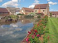
 / 53.05503; -1.20519 (Brewhouse, crewyard and mill barn, Hall Farm)
Hall Farm - geograph.org.uk - 3329870.jpg
Late 18th centuryThe farm and mill buildings are in stone and brick, with roofs of tile, pantile and asbestos. They form a C-shaped plan, with ranges of five and seven bays, and have a single storey or two storeys and attics. The windows are a mix of casements and horizontally-sliding sashes. The brewhouse is on the left, and has external steps, and the crewyard has stables in seven bays. The mill barn also has external steps, with a kennel, and adjoining it is a wheelpit containing an iron waterwheel. [6] [19] II*
The Old Mill
53°03′13″N1°12′18″W / 53.05361°N 1.20507°W / 53.05361; -1.20507 (The Old Mill)
The Old Mill, Linby - geograph.org.uk - 431526.jpg
Late 18th centuryA cart shed and outbuilding converted into a house, it is in stone with quoins and a pantile roof. There are two storeys and an L-shaped plan, with a main range of three bays. The windows are top-hung casements, those in the rear wing with keystones. On the east front are three cart openings with square piers and segmental heads, and on the north gable is an external staircase. [20] II
Weir Mill House and Cottage
53°03′44″N1°11′53″W / 53.06232°N 1.19807°W / 53.06232; -1.19807 (Weir Mill House and Cottage)
Late 18th centuryThe house and cottage are in stone with slate roofs. There are two storeys and attics, and an L-shaped plan, with a main range of six unequal bays. The buildings contain two doorways, one with a hood on shaped brackets, and the other with a gabled hood, and the windows are a mix of casements, some with mullions, and horizontally-sliding sashes. To the right is a later extension with a half-round stair turret. [21] II
Barn, stable and cart sheds north of Weir Mill Farmhouse
53°03′48″N1°11′52″W / 53.06320°N 1.19777°W / 53.06320; -1.19777 (Barn, stable and cart sheds north of Weir Mill Farmhouse)
Late 18th centuryThe farm buildings are in stone, and have roofs of tile, pantile, slate and asbestos sheet with coped gables. The buildings include a barn with various openings, external steps with a kennel below, and the remains of a pigeoncote in the gable, a stable with three bays, a four-bay cart shed, and an open cart shed with five bays. [22] II
Castle Mill
53°03′13″N1°11′17″W / 53.05362°N 1.18795°W / 53.05362; -1.18795 (Castle Mill)
Castle Mill Farm, Papplewick - geograph.org.uk - 38021.jpg
c. 1783A cotton mill and cottage converted into three dwellings in about 1960. It is in stone on a partial plinth, with an embattled parapet, and a roof of tile and slate with one coped gable. There are two storeys and a basement, and six unequal bays. Most of the windows are casements, those on the front with architraves, and there are French windows, some with balconies. On the north front are two embattled towers, each with two roundels and a quatrefoil. On the south front are the remains of a wheelpit. [6] [23] II
5, 6 and 7 Main Street
53°03′12″N1°12′19″W / 53.05338°N 1.20517°W / 53.05338; -1.20517 (5, 6 and 7 Main Street)
5, 6 and 7 Main Street, Linby.jpg
Early 19th centuryA row of three cottages in stone with tile roofs. There are two storeys and an L-shaped plan, with a front range of seven bays, a lean-to on the left, and a rear wing. On the front are doorways, and windows which are mainly horizontally-sliding sashes. The adjoining boundary wall has half-round coping and a square corner pier, and it extends for about 40 metres (130 ft). [24] II
12 Main Street
53°03′16″N1°12′11″W / 53.05448°N 1.20316°W / 53.05448; -1.20316 (12 Main Street)
Early 19th centuryA stone house that has a pantile roof with coped gables. There are two storeys, two bays and rear wings. In the centre is a doorway, the windows are casements, and the ground floor openings have segmental heads. [25] II
Clematis Cottage
53°03′15″N1°12′15″W / 53.05403°N 1.20424°W / 53.05403; -1.20424 (Clematis Cottage)
Early 19th centuryThe house is in stone and brick, with a slate roof, two storeys, three bays and a rear extension. The doorway is in the centre, and the windows are casements. [26] II
Water Mill and stables, Colliery Farm
53°03′14″N1°12′19″W / 53.05378°N 1.20529°W / 53.05378; -1.20529 (Water Mill and stables, Colliery Farm<)
Early 19th centuryThe water mill and stable are in stone and brick with asbestos cement roofs. There is a single storey and lofts, and an L-shaped plan, with a main range of three bays. The mill has a doorway to the waterwheel, and vents. The stable has a casement window and a doorway, to the right are cart openings with a central pier, and further to the right is a doorway flanked by casement windows, all with keystones, and inside is a pair of millstones. [27] II
Glebe boundary marker south of the Old Rectory
53°03′09″N1°12′05″W / 53.05261°N 1.20139°W / 53.05261; -1.20139 (Glebe boundary marker south of the Old Rectory)
Early 19th centuryThe boundary marker consists of a round-headed stone inscribed "South and West boundary of Glebe". [28] II
Glebe boundary marker southeast of the Old Rectory
53°03′10″N1°12′02″W / 53.05288°N 1.20067°W / 53.05288; -1.20067 (Glebe boundary marker southeast of the Old Rectory)
Early 19th centuryThe boundary marker consists of a round-headed stone inscribed "South and East boundary of Glebe". [29] II
Telephone kiosk
53°03′16″N1°12′09″W / 53.05433°N 1.20263°W / 53.05433; -1.20263 (Telephone kiosk)
Main Street, Linby - geograph.org.uk - 2748148.jpg
1935The K6 type telephone kiosk in Main Street was designed by Giles Gilbert Scott. Constructed in cast iron with a square plan and a dome, it has three unperforated crowns in the top panels. [30] II

Related Research Articles

Cockerham is a civil parish in Lancaster, Lancashire, England. It contains 19 listed buildings that are recorded in the National Heritage List for England. Of these, two are listed at Grade II*, the middle grade, and the others are at Grade II. Apart from the village of Cockerham, the parish is rural, and most of the listed buildings are houses, cottages, farmhouses and farm buildings. The other listed buildings include a church, the base of a sundial, boundary stones, and a bridge.

Halton-with-Aughton is a civil parish in Lancaster, Lancashire, England. It contains 46 listed buildings that are recorded in the National Heritage List for England. Of these, one is listed at Grade I, the highest of the three grades, three are at Grade II*, the middle grade, and the others are at Grade II, the lowest grade.

Over Wyresdale is a civil parish in Lancaster, Lancashire, England. It contains 53 buildings that are recorded in the National Heritage List for England as designated listed buildings. Of these, one is at Grade II*, the middle grade, and the others are at Grade II, the lowest grade.

Quernmore is a civil parish in Lancaster, Lancashire, England. It contains 28 listed buildings that are recorded in the National Heritage List for England. Of these, one is listed at Grade I, the highest of the three grades, one is at Grade II*, the middle grade, and the others are at Grade II, the lowest grade. Apart from the small village of Quernmore, the parish is rural. Most of the listed buildings are houses, farmhouses, and associated structures. The most important house in the parish is Quernmore Park; this and associated buildings are listed. The other listed buildings include a church, a former school, an aqueduct, a former corn mill, and a former railway bridge.

Tatham is a civil parish in Lancaster, Lancashire, England. It contains 47 buildings that are recorded in the National Heritage List for England as designated listed buildings. Of these, two are at Grade II*, the middle grade, and the others are at Grade II, the lowest grade. Apart from the small settlement of Lowgill, the parish is rural, containing widespread farms. Most of the listed buildings are farmhouses, farm buildings and houses. The other listed buildings include two churches, two boundary stones, a derelict colliery engine house, a public house, and a telephone kiosk.

Whittington is a civil parish in Lancaster, Lancashire, England. It contains 39 buildings that are recorded in the National Heritage List for England as designated listed buildings. Of these, three are at Grade II*, the middle grade, and the others are at Grade II, the lowest grade. The parish contains the villages of Whittington, Docker and Newton, and is otherwise rural. Most of the listed buildings are country houses with associated structures, smaller houses, and farm buildings. The other listed buildings include a church with a sundial in the churchyard, buildings on a model farm, three milestones, a boundary stone, and a former school.

Downham is a civil parish in Ribble Valley, Lancashire, England. It contains 43 listed buildings that are recorded in the National Heritage List for England. Of these, three are at Grade II*, the middle grade, and the others are at Grade II, the lowest grade. The parish contains the village of Downham and surrounding countryside. Most of the listed buildings are in the village, and include Downham Hall and associated structures, houses and cottages, a church, a public house, a school, milestones, a bridge, and a set of stocks. Outside the village the listed buildings are farmhouses and farm buildings.

Brailsford is a civil parish in the Derbyshire Dales district of Derbyshire, England. The parish contains 35 listed buildings that are recorded in the National Heritage List for England. Of these, one is listed at Grade I, the highest of the three grades, and the others are at Grade II, the lowest grade. The parish contains the village of Brailsford and the hamlet of Ednaston, and the surrounding countryside. Most of the listed buildings are houses, cottages and associated structures, farmhouses and farm buildings. The other listed buildings include a church, a churchyard cross, a watermill, two boundary posts, two mileposts, a bridge, a school, and a well.

Eckington is a civil parish in the North East Derbyshire district of Derbyshire, England. The parish contains 81 listed buildings that are recorded in the National Heritage List for England. Of these, two are listed at Grade I, the highest of the three grades, two are at Grade II*, the middle grade, and the others are at Grade II, the lowest grade. The parish contains the town of Eckington, the villages of Renishaw, Ridgeway, and Spinkhill, the hamlet of Birley Hay, and the surrounding countryside. The major building in the parish is the country house, Renishaw Hall, which is listed, together with associated structures and items in its grounds. Most of the other listed buildings are houses, cottages and associated structures, farmhouses and farm buildings. The rest of the listed buildings include churches, chapels and associated items, a former Sunday school, a former toll house, a public house, and two bridges.

Eyam is a civil parish in the Derbyshire Dales district of Derbyshire, England. The parish contains 55 listed buildings that are recorded in the National Heritage List for England. Of these, one is listed at Grade I, the highest of the three grades, two are at Grade II*, the middle grade, and the others are at Grade II, the lowest grade. The parish contains the village of Eyam and the surrounding countryside. The history of the village is notable because when the plague broke out in 1666, the village went into voluntary quarantine to prevent the disease from spreading outside. Some of the listed buildings are associated with this event, including cottages occupied by the victims of the disease, and their gravestones. Most of the other listed buildings are houses, cottages and farmhouses and associated structures. The other listed buildings include a church, a cross and tombs in the churchyard, the rectory, a well head, water troughs, a set of stocks, and the former engine house to a lead mine,

Wormhill is a civil parish in the High Peak district of Derbyshire, England. The parish contains 26 listed buildings that are recorded in the National Heritage List for England. Of these, three are listed at Grade II*, the middle of the three grades, and the others are at Grade II, the lowest grade. The parish contains the village of Wormhill and the surrounding area. Most of the listed buildings are houses, cottages and associated structures, farmhouses and farm buildings. The other listed buildings include a church and associated structures, a village cross moved into the churchyard, a railway viaduct, and a memorial fountain.

Yeldersley is a civil parish in the Derbyshire Dales district of Derbyshire, England. The parish contains 14 listed buildings that are recorded in the National Heritage List for England. All the listed buildings are designated at Grade II, the lowest of the three grades, which is applied to "buildings of national importance and special interest". The parish is almost entirely rural, with no substantial settlements, and the listed buildings consist of houses, cottages and associated structures, farmhouses and farm buildings, and a milepost.

Youlgreave is a civil parish in the Derbyshire Dales district of Derbyshire, England. The parish contains 57 listed buildings that are recorded in the National Heritage List for England. Of these, one is listed at Grade I, the highest of the three grades, one is at Grade II*, the middle grade, and the others are at Grade II, the lowest grade. The parish contains the village of Youlgreave, the hamlet of Alport and the surrounding countryside. Most of the listed buildings are houses, cottages and associated structures, farmhouses and farm buildings. The other listed buildings include a church and associated structures, a public house, bridges, a milestone, a conduit head, a school, a youth hostel and a telephone kiosk.

Kirkby-in-Ashfield is a market town in the Ashfield district of Nottinghamshire, England. The town and its surrounding area contain 18 listed buildings that are recorded in the National Heritage List for England. All the listed buildings are designated at Grade II, the lowest of the three grades, which is applied to "buildings of national importance and special interest". Most of the listed buildings consist of houses, farmhouses, farm buildings and associated structures. The other listed buildings are a village cross, a pinfold, a well head, a church, a war memorial and a telephone kiosk.

Carlton in Lindrick is a civil parish in the Bassetlaw District of Nottinghamshire, England. The parish contains 39 listed buildings that are recorded in the National Heritage List for England. Of these, one is listed at Grade I, the highest of the three grades, and the others are at Grade II, the lowest grade. The parish contains the villages of Carlton in Lindrick and Wigthorpe and the surrounding area. Most of the listed buildings are houses, cottages and associated structures, farmhouses and farm buildings. The other listed buildings include a church and memorials in the churchyard, a former watermill and associated structures, a former toll house, schools, a bridge and a war memorial.

East Bridgford is a civil parish in the Rushcliffe district of Nottinghamshire, England. The parish contains 20 listed buildings that are recorded in the National Heritage List for England. Of these, one is listed at Grade I, the highest of the three grades, and the others are at Grade II, the lowest grade. The parish contains the village of East Bridgford and the surrounding area. The listed buildings consist of houses and associated structures, farmhouses and farm buildings, a church and headstones in the churchyard, a former windmill, and a war memorial.

Flintham is a civil parish in the Rushcliffe district of Nottinghamshire, England. The parish contains 38 listed buildings that are recorded in the National Heritage List for England. Of these, two are listed at Grade I, the highest of the three grades, and the others are at Grade II, the lowest grade. The parish contains the village of Flintham and the surrounding area. The most important buildings in the parish are a church and the country house, Flintham Hall, which are both listed at Grade I. A number of structures associated with the hall are listed, and the other listed buildings consist of houses, cottages and associated structures, farmhouses and farm buildings, a pinfold, a former school and a telephone kiosk.

Greasley is a civil parish in the Borough of Broxtowe, Nottinghamshire, England. The parish contains 30 listed buildings that are recorded in the National Heritage List for England. Of these, two are listed at Grade II*, the middle of the three grades, and the others are at Grade II, the lowest grade. The parish contains the settlements of Beauvale, Moorgreen and Watnall and the surrounding area. Most of the listed buildings are houses, cottages and associated structures, farmhouses and farm buildings. The others include the remains of a fortified manor house, a church and a former chapel, and a school.

Kirklington is a civil parish in the Newark and Sherwood district of Nottinghamshire, England. The parish contains 13 listed buildings that are recorded in the National Heritage List for England. Of these, one is listed at Grade II*, the middle of the three grades, and the others are at Grade II, the lowest grade. The parish contains the village of Kirklington and the surrounding countryside. All the listed buildings are in the village, and consist of houses, cottages, farmhouses and farm buildings, a church, a school, a village hall, a water mill and an adjoining road bridge, and a telephone kiosk.

Kneeton is a civil parish in the Rushcliffe district of Nottinghamshire, England. The parish contains ten listed buildings that are recorded in the National Heritage List for England. All the listed buildings are designated at Grade II, the lowest of the three grades, which is applied to "buildings of national importance and special interest". The parish contains the village of Kneeton and the surrounding area. All the listed buildings are in the village, and consist of a church, headstones in the churchyard, houses, cottages and associated structures, farmhouses and farm buildings.

References

Citations

Sources