Listed buildings in Preston Patrick

Last updated

Preston Patrick is a civil parish in the South Lakeland District of Cumbria, England. It contains 24 listed buildings that are recorded in the National Heritage List for England. Of these, one is listed at Grade II*, the middle of the three grades, and the others are at Grade II, the lowest grade. The parish contains the villages of Preston Patrick and Crooklands, and is otherwise mainly rural. The Lancaster Canal passes through the parish, and the listed buildings associated with it are bridges, an aqueduct, and milestones. The other listed buildings consist of houses and associated structures, farmhouses, farm buildings, boundary stones, milestones on roads, and a church.

Preston Patrick village and civil parish in South Lakeland, Cumbria, England

Preston Patrick is a village and civil parish in South Lakeland, Cumbria, England. It has junction 36 of the M6 motorway in its south west corner and extends north east on both sides of the motorway until just beyond the B2564 road. In the 2011 census its population was reported to be 426. The neighbouring parishes are Old Hutton and Holmescales to the north, Lupton to the east, Beetham to the south and Preston Richard to the west.

Civil parish territorial designation and lowest tier of local government in England, UK

In England, a civil parish is a type of administrative parish used for local government, they are a territorial designation which is the lowest tier of local government below districts and counties, or their combined form, the unitary authority. Civil parishes can trace their origin to the ancient system of ecclesiastical parishes which historically played a role in both civil and ecclesiastical administration; civil and religious parishes were formally split into two types in the 19th century and are now entirely separate. The unit was devised and rolled out across England in the 1860s.

South Lakeland District in England

South Lakeland is a local government district in Cumbria, England. The population of the non-metropolitan district at the 2011 Census was 103,658. Its council is based in Kendal. It includes much of the Lake District as well as northwestern parts of the Yorkshire Dales.

Contents

Key

Map all coordinates using: OpenStreetMap  ·  Google Maps
Download coordinates as: KML  ·  GPX
Grade Criteria [1]
II* Particularly important buildings of more than special interest
II Buildings of national importance and special interest

Buildings

Name and locationPhotographDateNotesGrade
Preston Patrick Hall
54°14′51″N2°42′03″W / 54.24737°N 2.70084°W / 54.24737; -2.70084 (Preston Patrick Hall)
Preston Patrick Hall, Cumbria (geograph 2040137).jpg
A hall house with cross-wings that has been remodelled, heightened and altered. It is in stone with sandstone quoins, and has a green slate roof with a stone ridge and copings. There are two storeys, a central block of three bays flanked by gabled cross-wings. On the front is a gabled slated porch with bargeboards. Most of the windows are sash windows, and there are also traceried windows and other openings, some with hood moulds. [2] [3]
Bank barns, Preston Patrick Hall
54°14′50″N2°42′01″W / 54.24719°N 2.70036°W / 54.24719; -2.70036 (Bank barns, Preston Patrick Hall)
The barns were altered and extended later. They consist of a range of bank barns over cow houses, and are in stone with limestone quoins, and have green slate roofs with stone ridges. The left part contains openings with stone or timber lintels, the openings in the middle part have segmental heads, and the right part they have timber lintels and an inserted traceried window. [4]
Moss End Farmhouse
54°13′54″N2°42′51″W / 54.23163°N 2.71413°W / 54.23163; -2.71413 (Moss End Farmhouse)
A roughcast farmhouse with sandstone dressings and a green slate roof with a stone ridge and copings. There are two storeys with attics and five bays. On the front is a later gabled slated porch, and the doorway has a moulded lintel. The windows are sashes. [5]
Wath Sutton Farmhouse
54°14′15″N2°43′23″W / 54.23740°N 2.72306°W / 54.23740; -2.72306 (Wath Sutton Farmhouse)
The farmhouse is pebbledashed and has a green slate roof with a stone ridge. There are two storeys with attics and five bays. In the centre is a gabled porch, and all the windows are 20th-century casements. Inside many original features have been retained. [6]
Summerdale House
54°13′51″N2°41′55″W / 54.23087°N 2.69864°W / 54.23087; -2.69864 (Summerdale House)
1736Originally a vicarage, later a private house, it was remodelled and extended to the right in the 19th century. The house is in stone, partly rendered, with limestone quoins, a sill band, a moulded cornice, and a green slate roof with a stone ridge. There are two storeys, a main block with a symmetrical front of three bays, and a lower extension to the right. The central doorway has a limestone doorcase with pilasters and an entablature, and a decorative fanlight. The windows in the main block are sashes, and in the extension they are casements. [7]
Barn and other farm buildings,
Moss End Farm
54°13′55″N2°42′51″W / 54.23199°N 2.71426°W / 54.23199; -2.71426 (Barn and other farm buildings, Moss End Farm)
The buildings consist of a barn with a cow house beneath it, and a wagon shed and stores at right angles. They are in limestone with quoins, and have green slate roofs with stone ridges. The barn has ten bays, and contains a ramp leading to a wagon entrance, four openings in the upper floor and five in the ground floor. On the gables are ball finials. [8]
Spout House Farmhouse
54°13′48″N2°41′38″W / 54.22993°N 2.69398°W / 54.22993; -2.69398 (Spout House Farmhouse)
The farmhouse was remodelled in the late 19th century. It is in limestone with sandstone dressings, chamfered quoins, and a green slate roof with a stone ridge. There are two storeys and three bays. The central doorway has a stone surround with a cornice, the windows are sashes, and at the rear is a tall stair window. [9]
Challon Hall
54°15′18″N2°42′13″W / 54.25503°N 2.70359°W / 54.25503; -2.70359 (Challon Hall)
1760 or earlierA roughcast house with stone dressings, a band, and a green slate roof with a stone ridge. There are two storeys and five bays. The central doorway has a moulded surround and a lintel decorated with an ogee pattern and rosettes. In the right gable is a pediment with a plaque containing initials, the date, scrolling, and an egg and dart surround. [10] [11]
Dovehouses Bridge
54°13′49″N2°42′31″W / 54.23034°N 2.70860°W / 54.23034; -2.70860 (Dovehouses Bridge)
Dovehouses Bridge.jpg
The bridge carries Dovehouses Lane over the Lancaster Canal. It is in limestone, and consists of a single elliptical arch. The bridge has string courses, rusticated voussoirs and keystones, and shallow arched parapets with coping and end pilasters. The width of the bridge between the parapets is about 3.5 metres (11 ft). [12]
Millness Bridge
54°14′28″N2°42′44″W / 54.24098°N 2.71216°W / 54.24098; -2.71216 (Millness Bridge)
Millness Bridge.jpg
The bridge carries Millness Lane over the Lancaster Canal. It is in limestone, and consists of a single elliptical arch. The bridge has string courses, rusticated voussoirs and keystones, and ramped parapets with a slightly curved plan, coping, and end pilasters. The width of the bridge between the parapets is about 3.5 metres (11 ft). [13]
Seven Milestone Bridge
54°14′14″N2°42′35″W / 54.23709°N 2.70972°W / 54.23709; -2.70972 (Seven Milestone Bridge)
Seven Milestone Bridge.jpg
The bridge carries the A65 road over the Lancaster Canal. It is in limestone, and consists of a single elliptical arch. The bridge has string courses, rusticated voussoirs and keystones, and shallow arched parapets with a slightly curved plan, coping, and end pilasters. The width of the bridge between the parapets is about 6 metres (20 ft). [14]
Canal milestone near Crooklands aqueduct
54°14′35″N2°42′52″W / 54.24307°N 2.71454°W / 54.24307; -2.71454 (Canal milestone near Crooklands aqueduct)
The milestone is on the towpath of the Lancaster Canal. It is in limestone and consists of an upright post with a rounded top. It is inscribed with numbers in ovals representing the distances in miles to Lancaster and Kendal. [15]
Canal milestone near Dovehouses Bridge
54°13′47″N2°42′33″W / 54.22960°N 2.70906°W / 54.22960; -2.70906 (Canal milestone near Dovehouses Bridge)
Lancaster Canal near Dovehouses Bridge.jpg
The milestone is on the towpath of the Lancaster Canal. It is in limestone and consists of an upright post with a rounded top. It is inscribed with numbers in ovals representing the distances in miles to Lancaster and Kendal. [16]
Aqueduct over Peasey Beck
54°14′38″N2°42′55″W / 54.24390°N 2.71537°W / 54.24390; -2.71537 (Aqueduct over Peasey Beck)
Crooklands Aqueduct - geograph.org.uk - 1713863.jpg
The aqueduct carries the Lancaster Canal over Peasey Beck. It is in limestone, and consists of two shallow elliptical arches with a central cutwater. The aqueduct has a string course, copings, rusticated voussoirs, and curved retaining walls. It is about 30 feet (9.1 m) wide. [17]
Boundary Stone adjacent to Barkinbeck Bridge
54°15′33″N2°38′43″W / 54.25918°N 2.64527°W / 54.25918; -2.64527 (Boundary stone adjacent to Barkinbeck Bridge)
Boundary stone, Barkinbeck Bridge.jpg
The boundary stone is in limestone, and consists of an upright stone with deep chamfers. It is inscribed with the names of the parishes of Preston Patrick and of Lupton. [18]
Boundary stone near Crosslands Farm
54°16′19″N2°39′29″W / 54.27205°N 2.65793°W / 54.27205; -2.65793 (Boundary stone near Crosslands Farm)
The milestone is about 2 feet (0.61 m) high, and has a triangular plan and a domical top. It is inscribed with the names of the parishes of Old Hutton and of Preston Patrick. [19]
Barn, Spout House Farm
54°13′47″N2°41′38″W / 54.22971°N 2.69381°W / 54.22971; -2.69381 (Barn, Spout House Farm)
This consists of a barn with a cow house and a cart shed beneath, and a store at right angles. It is in limestone with through-stones, quoins, and a green slate roof with a stone ridge and copings. It contains a wagon door with a segmental head and voussoirs, doors, and a casement window. [20]
Boundary stone near Spout House Farmhouse
54°13′40″N2°41′27″W / 54.22771°N 2.69072°W / 54.22771; -2.69072 (Boundary stone near Spout House Farmhouse)
The boundary stone is in limestone, and consists of an upright stone with deep chamfers. It is inscribed with the names of the parishes of Preston Patrick and of Lupton. [21]
Milestone near Barkin House
54°15′44″N2°39′00″W / 54.26229°N 2.65013°W / 54.26229; -2.65013 (Milestone near Barkin House)
Milestone - geograph.org.uk - 124063.jpg
The milestone is in limestone and consists of an upright stone with a round head and chamfers. It is inscribed with the distances in miles to Kirkby Lonsdale and to Kendal. [22]
Waggon shed and barn,
Preston Patrick Hall
54°14′50″N2°42′03″W / 54.24711°N 2.70096°W / 54.24711; -2.70096 (Waggon shed and barn, Preston Patrick Hall)
The wagon shed and barn are in stone with limestone quoins, and have a green slate roof, hipped to the north, with a stone ridge. The building contains a wagon door with a segmental-arched head and limestone voussoirs, and two tiers of ventilation slits. [23]
Garden walls and gateways, Summerdale House
54°13′51″N2°41′53″W / 54.23075°N 2.69817°W / 54.23075; -2.69817 (Garden walls and gateways, Summerdale House)
The walls are on the north and east sides of the garden. They are in stone with limestone copings, and are between 2.4 metres (7 ft 10 in) and 3 metres (9.8 ft) high. In the east wall is a round-arched opening with voussoirs and a wooden gate. The north wall contains an opening with a stone lintel and a wrought iron gate, and attached to the wall is a small arch with limestone voussoirs. [24]
Milestone near Summerdale House
54°13′54″N2°41′56″W / 54.23171°N 2.69877°W / 54.23171; -2.69877 (Milestone near Summerdale House)
The milestone is in limestone and consists of an upright stone with a round head and chamfers. It is inscribed with the distances in miles to Kirkby Lonsdale and to Kendal. [25]
Milestone near Seven Milestone Bridge
54°14′15″N2°42′35″W / 54.23747°N 2.70962°W / 54.23747; -2.70962 (Milestone near Seven Milestone Bridge)
1826The milestone was provided for the Heronsyke Turnpike. It is in cast iron, and is half-hexagonal with fluted faces and a domed top. The milestone is inscribed with the distances in miles to Burton-in-Kendal and to Kendal. [26]
St Patrick's Church
54°14′43″N2°42′43″W / 54.24524°N 2.71189°W / 54.24524; -2.71189 (St Patrick's Church)
St Patrick's Church, Preston Patrick, Cumbria.jpg
1852–53The church was designed by Sharpe and Paley in Perpendicular style, and the chancel was rebuilt by their successors, Paley, Austin and Paley in 1891–92. It is built in limestone on a chamfered plinth, with sandstone dressings in the chancel, a cornice, and it has a slate roof with a stone ridge and copings. The church consists of a nave, a north aisle, a south porch, a chancel, a north vestry, and a west tower. The tower has four stages, diagonal buttresses, an embattled parapet, and there is an octagonal stair turret at the southwest corner rising to a higher level. Incorporated in the church are 15th-century items from and earlier church, namely, a window in the tower, and niches in the chancel. [27] [28]

Related Research Articles

Lea is a civil parish in Lancashire, England. It contains 12 buildings that are recorded in the National Heritage List for England as designated listed buildings. Of these, one is listed at Grade I, the highest of the three grades, and all the others are at Grade II. The parish is partly residential, but mainly rural, and the Lancaster Canal runs through it. Four bridges crossing the canal are listed, the other listed buildings being houses, farmhouses and associated structures, and a cross that probably has a medieval origin.

Barton is a civil parish in the City of Preston, Lancashire, England. It contains ten listed buildings that are recorded in the National Heritage List for England. Of these, one is at Grade II*, the middle grade, and the others are at Grade II, the lowest grade. The parish contains the village of Barton and surrounding countryside. Running through it is the Lancaster Canal, and a bridge crossing it and an aqueduct are listed. The other listed buildings include farm buildings, milestones, a church, and a cross.

Beetham is a civil parish in the South Lakeland District of Cumbria, England. It contains 47 listed buildings that are recorded in the National Heritage List for England. Of these, two are listed at Grade I, the highest of the three grades, four are at Grade II*, the middle grade, and the others are at Grade II, the lowest grade. The parish contains the villages of Beetham, Farleton and Hazelslack, and the surrounding countryside. The Lancaster Canal passes through the parish, and the listed buildings associated with this are bridges, an aqueduct and a milestone. Most of the listed buildings in the parish are houses, some of them originally tower houses, and associated structures, farmhouses and farm buildings. The other listed buildings consist of a church, bridges, a former corn mill, milestones and a milepost, boundary stones and a boundary post, a former school, a signal box, and a war memorial.

Burton-in-Kendal is a civil parish in the South Lakeland District of Cumbria, England. It contains 32 listed buildings that are recorded in the National Heritage List for England. Of these, one is listed at Grade I, the highest of the three grades, one is at Grade II*, the middle grade, and the others are at Grade II, the lowest grade. The parish contains the village of Burton-in-Kendal and the surrounding countryside. The Lancaster Canal passes through the parish, and the listed buildings associated with this are a bridge, an aqueduct, and a milestone. The other listed buildings are located in the village, apart from two boundary stones, a milestone, and a farmhouse. In the village, the listed buildings include houses and associated structures, a church and items in the churchyard, hotels, public houses, a market cross, and a commemorative lamp post.

Cartmel Fell is a civil parish in the South Lakeland District of Cumbria, England. It contains 34 listed buildings that are recorded in the National Heritage List for England. Of these, three are listed at Grade I, the highest of the three grades, two are at Grade II*, the middle grade, and the others are at Grade II, the lowest grade. The parish is in the Lake District National Park, and is mainly rural. Most of the listed buildings are houses and associated structures, farmhouses and farm buildings. The other listed buildings include a church and items in the churchyard, bridges, a milestone, a war memorial, and a public house

Claife is a civil parish in the South Lakeland District of Cumbria, England. It contains 45 listed buildings that are recorded in the National Heritage List for England. Of these, four are listed at Grade II*, the middle of the three grades, and the others are at Grade II, the lowest grade. The parish is in the Lake District National Park to the west of Windermere. It contains the villages and settlements of Far Sawrey, Near Sawrey, Colthouse, Loanthwaite, High Wray and Low Wray, and the surrounding countryside. Most of the listed buildings are farmhouses, farm buildings, and houses with associated structures. The other listed buildings include churches, a public house, and a bridge.

Coniston is a civil parish in the South Lakeland District of Cumbria, England. It contains 53 listed buildings that are recorded in the National Heritage List for England. Of these, four are listed at Grade II*, the middle of the three grades, and the others are at Grade II, the lowest grade. The parish is in the Lake District National Park and is located to the west, north and east of Coniston Water. Most of the listed buildings are houses and associated structures, farmhouses and farm buildings. The other listed buildings include bridges, a limekiln, a folly, a boundary stone, a church, a drinking fountain, and a memorial.

Helsington is a civil parish in the South Lakeland District of Cumbria, England. It contains 21 listed buildings that are recorded in the National Heritage List for England. Of these, one is listed at Grade I, the highest of the three grades, one is at Grade II*, the middle grade, and the others are at Grade II, the lowest grade. The parish includes the village of Brigsteer, and is otherwise rural. The major listed buildings in the parish are Sizergh Castle and associated structures. The other listed buildings include farmhouses, farm buildings, houses, bridges, a church, a snuff mill, and buildings associated with a former gunpowder works.

Hincaster is a civil parish in the South Lakeland District of Cumbria, England. It contains eleven listed buildings that are recorded in the National Heritage List for England. Of these, one is listed at Grade II*, the middle of the three grades, and the others are at Grade II, the lowest grade. The parish contains the village of Hincaster and the surrounding countryside. The Lancaster Canal passed through the parish, including the Hincaster Tunnel. This part of the canal is now dry, but structures associated with it are listed, including the portals of the tunnel, a cottage, and accommodation bridges and a railway bridge crossing the canal or the sunken horse path. The other listed buildings are farmhouses and farm buildings.

Holme is a civil parish in the South Lakeland District of Cumbria, England. It contains 14 listed buildings that are recorded in the National Heritage List for England. All the listed buildings are designated at Grade II, the lowest of the three grades, which is applied to "buildings of national importance and special interest". The parish contains the village of Holme and the surrounding countryside. The Lancaster Canal passes through the parish, and nine structures on the canal are listed, eight bridges and a milepost. The other listed buildings are a house, a farmhouse, two boundary stones, and a milepost on a road.

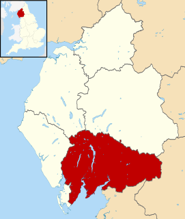
Kendal is a civil parish in the South Lakeland District of Cumbria, England. It contains 187 listed buildings that are recorded in the National Heritage List for England. Of these, three are listed at Grade I, the highest of the three grades, twelve are at Grade II*, the middle grade, and the others are at Grade II, the lowest grade. The parish contains the market town of Kendal, and its surroundings. The major industries historically were wool, weaving and dyeing, and snuff is still made in the town. The Lancaster Canal came to the town in 1819, and this created new industries, including a large shoe and boot factory.

Lupton is a civil parish in the South Lakeland District of Cumbria, England. It contains 13 listed buildings that are recorded in the National Heritage List for England. All the listed buildings are designated at Grade II, the lowest of the three grades, which is applied to "buildings of national importance and special interest". The parish is almost completely rural, without any major settlement. The listed buildings consist of houses, farmhouses, farm buildings, a church, a bridge, milestones, and a boundary stone.

Middleton is a civil parish in the South Lakeland District of Cumbria, England. It contains 22 listed buildings that are recorded in the National Heritage List for England. Of these, five are listed at Grade II*, the middle of the three grades, and the others are at Grade II, the lowest grade. The parish contains the village of Middleton, and is otherwise rural. Most of the listed buildings are houses and associated structures, farmhouses and farm buildings. The other listed buildings include milestones, one of which dates back to the Roman era, a church and items in the churchyard, and bridges.

Natland is a civil parish in the South Lakeland District of Cumbria, England. It contains 14 listed buildings that are recorded in the National Heritage List for England. Of these, one is listed at Grade II*, the middle of the three grades, and the others are at Grade II, the lowest grade. The parish contains the village of Natland, and is otherwise rural. The listed buildings include houses, farmhouses, farm buildings, bridges, a church, a milestone, and a boundary post.

Old Hutton and Holmescales is a civil parish in the South Lakeland District of Cumbria, England. It contains eight listed buildings that are recorded in the National Heritage List for England. Of these, one is listed at Grade II*, the middle of the three grades, and the others are at Grade II, the lowest grade. The parish contains the village of Old Hutton and the hamlet of Middleshaw, and is otherwise entirely rural. The listed buildings consist of three houses, a former gateway, three milestones and a boundary stone.

Preston Richard is a civil parish in the South Lakeland District of Cumbria, England. It contains 14 listed buildings that are recorded in the National Heritage List for England. All the listed buildings are designated at Grade II, the lowest of the three grades, which is applied to "buildings of national importance and special interest". The parish contains the villages of Endmoor and Crooklands and is otherwise almost entirely rural. The Lancaster Canal runs through the parish, and the listed buildings associated with this are four bridges, an aqueduct, and a milestone. The other listed buildings consist of houses and associated structures, farmhouses, a former mill, two road milestones, and a boundary stone.

Sedgwick is a civil parish in the South Lakeland District of Cumbria, England. It contains five listed buildings that are recorded in the National Heritage List for England. All the listed buildings are designated at Grade II, the lowest of the three grades, which is applied to "buildings of national importance and special interest". The parish contains the village of Sedgwick and the surrounding countryside. The Lancaster Canal passed through the parish, but it now dry in this area; There are two listed buildings associated with it, an aqueduct and a bridge. The other listed buildings are a farmhouse, and a former country house and its gatehouse.

Stainton is a civil parish in the South Lakeland District of Cumbria, England. It contains eleven listed buildings that are recorded in the National Heritage List for England. All the listed buildings are designated at Grade II, the lowest of the three grades, which is applied to "buildings of national importance and special interest". The parish contains the village of Stainton, and is otherwise rural. The Lancaster Canal passes through the parish and a number of structures associated with it are listed. The other listed buildings include a farmhouse, a packhorse bridge, a church, a boundary stone, a boundary post, and a milestone.

Staveley-in-Cartmel is a civil parish in the South Lakeland District of Cumbria, England. It contains 22 listed buildings that are recorded in the National Heritage List for England. Of these, one is listed at Grade II*, the middle of the three grades, and the others are at Grade II, the lowest grade. The parish is in the Lake District National Park. It contains the villages of Staveley-in-Cartmel and Newby Bridge, and smaller settlements, but is mainly rural. In the parish is Fell Foot Park, a country park on the shore of Windermere; four buildings in this park have been listed. The other listed buildings include farmhouses, farm buildings, other houses, a milestone, a bridge, a church, and a sundial in the churchyard.

Blackrod is a civil parish in the Metropolitan Borough of Bolton, Greater Manchester, England. It contains 13 listed buildings that are recorded in the National Heritage List for England. All the listed buildings are designated at Grade II, the lowest of the three grades, which is applied to "buildings of national importance and special interest". The parish is partly residential but mainly rural. The Leeds and Liverpool Canal passes through the parish and there are five listed buildings associated with it, an aqueduct and four bridges. The other listed buildings are a former country house and associated structures, farmhouses, a hotel, a church, and a war memorial.

References

Citations

Sources

Historic England Executive non-departmental public body of the British Government, tasked with protecting the historical environment of England

Historic England is an executive non-departmental public body of the British Government sponsored by the Department for Culture, Media and Sport (DCMS). It is tasked with protecting the historical environment of England by preserving and listing historic buildings, ancient monuments and advising central and local government.

The National Heritage List for England (NHLE) is England’s official list of buildings, monuments, parks and gardens, wrecks, battlefields and World Heritage Sites. It is maintained by Historic England and brings together these different designations as a single resource even though they vary in the type of legal protection afforded to each. Conservation areas do not appear on the NHLE since they are designated by the relevant local planning authority.

Nikolaus Pevsner German-born British scholar

Sir Nikolaus Bernhard Leon Pevsner was a German, later British scholar of the history of art, especially of architecture.