Listed buildings in Styrrup with Oldcotes

Last updated

Styrrup with Oldcotes is a civil parish in the Bassetlaw District of Nottinghamshire, England. The parish contains 22 listed buildings that are recorded in the National Heritage List for England. Of these, one is listed at Grade II*, the middle of the three grades, and the others are at Grade II, the lowest grade. The parish contains the villages of Oldcotes and Styrrup, and the surrounding countryside, including part of Serlby Park, the grounds of Serlby Hall. The listed buildings in Serlby Park include two bridges, an arch, a former laundry, and lodges. In the villages, the listed buildings include houses, cottage and associated structures, farmhouses and farm buildings, two churches and a chapel, a watermill and a war memorial.

Contents

Key

Map all coordinates using: OpenStreetMap
GradeCriteria [1]
II*Particularly important buildings of more than special interest
IIBuildings of national importance and special interest


Buildings

Name and locationPhotographDateNotesGrade
Yews Farmhouse
53°24′29″N1°05′16″W / 53.40811°N 1.08779°W / 53.40811; -1.08779 (Yews Farmhouse)
Yews Farmhouse - geograph.org.uk - 5063237.jpg
16th centuryThe farmhouse has a timber framed core, it was refronted in the late 18th century in red brick on a stone plinth, and it has a pantile roof. There are two storeys and three bays. In the centre is a doorway with a moulded wooden surround, to its top right is a small fixed light with a pointed head, between them is a wooden post, and the windows are sashes. To the left is a single-storey single-bay stone extension, and at the rear are horizontally-sliding sash windows. [2] II
Rose Farm Cottage
53°23′27″N1°06′40″W / 53.39082°N 1.11120°W / 53.39082; -1.11120 (Rose Farm Cottage)
Rose Farmhouse, Oldcotes - geograph.org.uk - 4320261.jpg
Early 18th centuryThe cottage is in stone, with quoins, and a pantile roof with stone coped gables and kneelers. There are two storeys, three bays, and a rear lean-to. The central doorway has an architrave, a keystone, a frieze and a cornice. Above the doorway is a round-arched fixed light with moulded imposts, and the other windows are casements. [3] II
Arch, Serlby Park
53°24′06″N1°02′54″W / 53.40173°N 1.04836°W
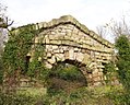
 / 53.40173; -1.04836 (Arch, Serlby Park)
Serlby Park arch (geograph 4260457).jpg
Early 18th centuryThe arch in the grounds of Serlby Hall is in stone and brick on a plinth. The arch has a keystone, and above it is a band and a pediment. On each side are two small rough rectangular openings, and on the north side are two brick buttressing walls. [4] [5] II*
Earl's House
53°23′24″N1°06′49″W / 53.39006°N 1.11366°W / 53.39006; -1.11366 (Earl's House)
Mid 18th centuryThe house is rendered, with stone dressings, chamfered quoins, and a pantile roof with stone coped gables and kneelers. There are two storeys and an L-shaped plan, with a main range of three bays, and a single-storey two-bay extension. The doorway is at the rear and has a rusticated surround and a hood. To its right is a bow window, and the other windows are a mix of sashes and casements. [6] II
The Old Hall
53°23′31″N1°07′06″W / 53.39201°N 1.11832°W / 53.39201; -1.11832 (The Old Hall)
The Old Hall, Oldcotes - geograph.org.uk - 4320273.jpg
Mid 18th centuryThe house is in painted stone, with the attic of the left gable rendered. It has a pantile roof with stone coped gables and kneelers. There are two storeys and attics, four bays, and a rear lean-to. The windows are casements with painted stone surrounds. [7] II
Bull Farmhouse
53°23′24″N1°06′52″W / 53.39005°N 1.11449°W / 53.39005; -1.11449 (Bull Farmhouse)
Late 18th centuryA stone cottage that has a pantile roof with stone coped gables and kneelers. There are two storeys and an L-shaped plan, with a front range of three bays. The doorway is in the centre, and the windows are casements. [8] II
Laundry Cottage
53°23′59″N1°02′16″W / 53.39982°N 1.03780°W
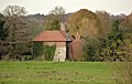
 / 53.39982; -1.03780 (Laundry Cottage)
The Laundry, Serlby Park - geograph.org.uk - 4260477.jpg
Late 18th centuryThe laundry in the grounds of Serlby Hall, later a private house, is in red brick with some stone, dentilled eaves and a hipped pantile roof. There are two storeys and an L-shaped plan, with two bays, a projecting two-storey single-bay wing on the right, a recessed lean-to on the left, and at the rear is a single-storey extension. The windows are a mix of casements, and horizontally-sliding sashes. [9] II
Oldcotes Mill
53°23′20″N1°06′26″W / 53.38901°N 1.10720°W / 53.38901; -1.10720 (Oldcotes Mill)
Late 18th centuryThe watermill is in stone with hipped pantile roofs. The north wing has three storeys and three bays, and the later south wing has two storeys and four bays. The water wheel is in situ, and the openings have flush stone surrounds. [10] [11] II
Bawtry Lodge
53°24′35″N1°02′40″W / 53.40973°N 1.04453°W / 53.40973; -1.04453 (Bawtry Lodge)
Early 19th centuryThe lodge at the entrance to the grounds of Serlby Hall is in stone, on a plinth, with projecting eaves and a hipped slate roof. There is a single storey and three bays, with the south front canted. The windows are casements. [4] [12] II
Harworth Lodge
53°24′15″N1°03′07″W / 53.40421°N 1.05203°W
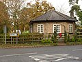
 / 53.40421; -1.05203 (Harworth Lodge)
Harworth Lodge, Snape Lane, Serlby - geograph.org.uk - 4260455.jpg
Early 19th centuryThe lodge at the entrance to the grounds of Serlby Hall is in stone, on a plinth, with projecting eaves and a hipped slate roof. There is a single storey and four bays, with the south front canted. The windows are casements. [4] [13] II
Ivy House Farmhouse
53°24′29″N1°05′17″W / 53.40803°N 1.08796°W / 53.40803; -1.08796 (Ivy House Farmhouse)
Early 19th centuryThe farmhouse, containing earlier material, is in painted brick, with stone on the ground floor of the gable end facing the road, on a stone plinth, with a floor band, dog tooth eaves and a pantile roof. There are two storeys, a double depth plan, a main range of three bays, and a recessed two-storey single-bay wing on the right, with a single-storey extension. The doorway has a fanlight, and most of the windows are sashes, those in the ground floor with segmental heads. [14] II
Bridge over River Ryton (east)
53°23′59″N1°02′25″W / 53.39981°N 1.04014°W / 53.39981; -1.04014 (Bridge over River Ryton (east))
Snape Lane bridge - geograph.org.uk - 4260464.jpg
1832The bridge carries a road over the River Ryton in the grounds of Serlby Hall. It is in stone, and consists of a single arch with a keystone and a band. The parapets are set on a plinth on the road side, and have moulded coping, and round terminal piers. At the north, the parapets curve outwards before terminating in the piers. [15] II
Bridge over River Ryton (west)
53°24′03″N1°02′44″W / 53.40075°N 1.04559°W / 53.40075; -1.04559 (Bridge over River Ryton (west))
c. 1832The bridge carries a road over the River Ryton in the grounds of Serlby Hall. It is in stone, with some brick on the underside of the arch, and consists of a single arch with a keystone and a band. The parapets are set on a plinth, and have moulded coping, and round terminal piers. [16] II
Wesleyan Chapel
53°23′27″N1°06′46″W / 53.39079°N 1.11280°W / 53.39079; -1.11280 (Wesleyan Chapel)
Oldcotes Methodist Chapel - geograph.org.uk - 4320252.jpg
1840The chapel is rendered, on a plinth, and has a hipped slate roof with an iron vent. In the centre is a gabled porch with a bargeboard, containing a double door with a semicircular fanlight, above which is an inscribed and dated plaque. The windows are round-headed casements. [10] [17] II
East Lodge
53°23′25″N1°06′34″W / 53.39041°N 1.10946°W / 53.39041; -1.10946 (East Lodge)
East Lodge to Hermeston Hall - geograph.org.uk - 4320219.jpg
c. 1855The lodge is in red brick on a brick plinth, with blue brick diapering, bands, stone dressings and a hipped slate roof. There is a single storey with an attic, and a single bay. On the front is a canted bay window with casements and decorated columns, and above is a gabled half-dormer with a bargeboard. To the right and recessed is a two-storey turret with a shaped pyramidal roof. It has dog tooth eaves over a Lombard frieze. At the rear is a doorway with decorated imposts, above which is an arch with blue brick and stone infill, and over that is a stone carved with a coat of arms. [10] [18] II
Manor Farm Farmhouse
53°23′27″N1°06′36″W / 53.39093°N 1.11007°W / 53.39093; -1.11007 (Manor Farm Farmhouse)
Manor Farmhouse - geograph.org.uk - 4320220.jpg
1855The farmhouse is in red brick on a plinth, with a chamfered stone course above, dressings in blue brick and stone, quoins, a floor band, and a slate roof with stone coped gables and a decorated ridge. There are two storeys and attics, and five bays, the left two bays under a gable. To the left is a recessed two-storey three-bay wing, and at the rear are two two-storey wings. In the centre is a gabled porch containing an arched window on the front and arched doorways on the sides, and a doorway with a fanlight. The windows are sashes with mullions or mullions and transoms, quoined surrounds and keystones, each in a relieving arch of red and blue brick. [10] [19] II
Farm buildings, Manor Farm
53°23′29″N1°06′35″W / 53.39131°N 1.10959°W / 53.39131; -1.10959 (Farm buildings, Manor Farm)
Farm buildings at Manor Farm - geograph.org.uk - 4320235.jpg
c. 1855The farm buildings are in red brick with stone dressings, they have slate roofs with stone coped gables, and include a range of two storeys and eleven bays. Projecting from the right is a two-storey barn, and projecting from this is a single-storey 15-bay range extending along the road, including a three-storey pigeoncote. The openings include doorways and casement windows, some with mullions and transoms. The pigeoncote has a hipped roof, surmounted by a large glover containing a band of blind arcading with pigeon openings, and a hipped roof with an iron ridge and weathervane. [10] [20] II
Garden wall, Manor Farmhouse
53°23′26″N1°06′36″W / 53.39060°N 1.10995°W
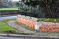
 / 53.39060; -1.10995 (Garden wall, Manor Farmhouse)
Garden wall and railings at Manor Farm - geograph.org.uk - 4320222.jpg
c. 1855The wall is in red brick, with triangular stone coping and decorative cast iron railings. At the southwest it rises to meet a pair of stone piers with shaped coping and a decorative iron gate, and there are similar piers and a gate at the northeast. The wall extends for 60 metres (200 ft) along the south of the garden and 20 metres (66 ft) on the east front. [21] II
Outbuilding, Manor Farm
53°23′28″N1°06′35″W / 53.39102°N 1.10973°W / 53.39102; -1.10973 (Outbuilding, Manor Farm)
Farm Buildings, Manor Farm, Oldcotes.jpg
c. 1855The outbuilding is in red brick with stone dressings, and a slate roof with stone coped gables. There is a single storey and five bays, and it contains doorways and windows, most with quoin jambs. To the right is a lower single-bay extension with an eaves band and a vent. [10] [22] II
St Helen's Church
53°23′25″N1°06′46″W / 53.39040°N 1.11283°W / 53.39040; -1.11283 (St Helen's Church)
St.Helen's church - geograph.org.uk - 632054.jpg
1868–69The church is in stone and has a tile roof with decorated ridges. It consists of a nave, a south porch, a chancel, a north vestry and organ chamber, and a northeast bell turret. At the west end is a four-light arched window, and the east window has five lights. [23] [24] II
St Mark's Church
53°23′30″N1°07′07″W / 53.39162°N 1.11859°W / 53.39162; -1.11859 (St Mark's Church)
Church of St Mark, Oldcotes - geograph.org.uk - 4320281.jpg
c. 1900The church, designed by C. Hodgson Fowler, is timber framed with plaster infill, on a red brick plinth with stone quoins, and it has a tile roof with bargeboards and overhanging eaves on wooden brackets. The church consists of a nave and a chancel under a single roof, with a north porch and a north vestry. The windows have wooden surround and mullions. [25] [26] II
Oldcotes War Memorial
53°23′30″N1°07′06″W / 53.39161°N 1.11844°W / 53.39161; -1.11844 (Oldcotes War Memorial)
Oldcotes War Memorial - geograph.org.uk - 4320277.jpg
1920The war memorial in the churchyard of St Mark's Church, to the east of the church, is in grey granite. It consists of a broken column with carvings of a sheathed sword and a wreath in relief. The column stands on a tapering rusticated plinth on a base of three steps. On the front of the plinth is an inscription and the names of these lost in the First World War, and on the second step is a flower-holder in memory of a later casualty. [27] II

Related Research Articles

Oldcotes is a village in Nottinghamshire, England. It is in the civil parish of Styrrup with Oldcotes. The village is centred on the crossroads of the A60 and A634 roads, five miles south east of Maltby.

Halton-with-Aughton is a civil parish in Lancaster, Lancashire, England. It contains 46 listed buildings that are recorded in the National Heritage List for England. Of these, one is listed at Grade I, the highest of the three grades, three are at Grade II*, the middle grade, and the others are at Grade II, the lowest grade.

<span class="mw-page-title-main">Styrrup with Oldcotes</span> Civil parish in England

Styrrup with Oldcotes is a civil parish in the Bassetlaw district, within the county of Nottinghamshire, England. The overall area had a population of 684 at the 2011 census. The parish lies in the north of the county. It is 138 miles north west of London, 31 miles north of the city of Nottingham, and 15 miles east of the city of Sheffield. The parish rests alongside the county border with South Yorkshire.

Grindleford is a civil parish in the Derbyshire Dales district of Derbyshire, England. The parish contains 26 listed buildings that are recorded in the National Heritage List for England. Of these, one is listed at Grade I, the highest of the three grades, one is at Grade II*, the middle grade, and the others are at Grade II, the lowest grade. The parish contains the village of Grindleford and the surrounding countryside. Most of the listed buildings are houses, cottages and farmhouses and associated structures. The other listed buildings include a former gatehouse converted into a chapel, two bridges, a milestone and a milepost, a former cotton mill, a former toll house, and another chapel.

Osmaston is a civil parish in the Derbyshire Dales district of Derbyshire, England. The parish contains 21 listed buildings that are recorded in the National Heritage List for England. Of these, one is listed at Grade II*, the middle of the three grades, and the others are at Grade II, the lowest grade. The parish contains the village of Osmaston and the surrounding area. The country house, Osmaston Manor, was built in the 1840s, and has been largely demolished, but its gardens and grounds contain listed buildings, including garden features, cottages and boat houses. The other listed buildings are houses, cottages and associated structures, a church, a school, a war memorial, and a telephone kiosk.

Over Haddon is a civil parish in the Derbyshire Dales district of Derbyshire, England. The parish contains nine listed buildings that are recorded in the National Heritage List for England. All the listed buildings are designated at Grade II, the lowest of the three grades, which is applied to "buildings of national importance and special interest". The parish contains the village of Over Haddon and the surrounding countryside. The listed buildings consist of four farmhouses and associated structures, a former cotton mill and sluice gate, a footbridge over the River Lathkill, a house, a church, and a telephone kiosk.

Wormhill is a civil parish in the High Peak district of Derbyshire, England. The parish contains 26 listed buildings that are recorded in the National Heritage List for England. Of these, three are listed at Grade II*, the middle of the three grades, and the others are at Grade II, the lowest grade. The parish contains the village of Wormhill and the surrounding area. Most of the listed buildings are houses, cottages and associated structures, farmhouses and farm buildings. The other listed buildings include a church and associated structures, a village cross moved into the churchyard, a railway viaduct, and a memorial fountain.

Yeldersley is a civil parish in the Derbyshire Dales district of Derbyshire, England. The parish contains 14 listed buildings that are recorded in the National Heritage List for England. All the listed buildings are designated at Grade II, the lowest of the three grades, which is applied to "buildings of national importance and special interest". The parish is almost entirely rural, with no substantial settlements, and the listed buildings consist of houses, cottages and associated structures, farmhouses and farm buildings, and a milepost.

Worksop is a market town in the Bassetlaw District of Nottinghamshire, England. The town contains over 100 listed buildings that are recorded in the National Heritage List for England. Of these, four are listed at Grade I, the highest of the three grades, five are at Grade II*, the middle grade, and the others are at Grade II, the lowest grade. The most important listed buildings are a former priory, later a parish church, the gatehouse to the priory, a lodge, and a country house, which are listed at Grade I, and structures associated with them are also listed. Most of the other listed buildings include houses, cottages and associated structures, shops, offices, farmhouses and farm buildings, public houses and hotels, public buildings and churches. The rest of the listed buildings include a market cross, a canal lock, schools, a bank, a railway station and a signal box, a pumping station, war memorials and a telephone kiosk.

Blyth is a civil parish in the Bassetlaw District of Nottinghamshire, England. The parish contains 53 listed buildings that are recorded in the National Heritage List for England. Of these, three are listed at Grade I, the highest of the three grades, and the others are at Grade II, the lowest grade. The parish contains the village of Blyth and the surrounding countryside. To the north of the village is the country house Serlby Hall, which is listed, together with associated structures around the house and in Serlby Park. The other listed buildings are in or around the village, and most of them are houses, cottages and associated structures, farmhouses and farm buildings. The other listed buildings include a church and items in the churchyard, a hotel and public houses, bridges, a milestone, a war memorial and a telephone kiosk.

Hodsock is a civil parish in the Bassetlaw District of Nottinghamshire, England. The parish contains 17 listed buildings that are recorded in the National Heritage List for England. Of these, one is listed at Grade I, the highest of the three grades, and the others are at Grade II, the lowest grade. The parish is almost entirely rural, containing no substantial settlements. The most important building in the parish is a 16th-century gatehouse, which is listed, together with its associated country house. The other listed buildings consist of houses and associated structures, farmhouses and farm buildings, a former watermill, a bridge and a war memorial.

Clayworth is a civil parish in the Bassetlaw District of Nottinghamshire, England. The parish contains 18 listed buildings that are recorded in the National Heritage List for England. Of these, one is listed at Grade I, the highest of the three grades, and the others are at Grade II, the lowest grade. The parish contains the village of Clayworth and the surrounding area. The Chesterfield Canal runs through the parish, and the listed buildings associated with it are a bridge, a warehouse and two mileposts. The other listed buildings consist of houses, cottages and associated structures, farmhouses and farm buildings, a former chapel, and a church and monuments in the churchyard.

Dunham-on-Trent is a civil parish in the Bassetlaw District of Nottinghamshire, England. The parish contains eleven listed buildings that are recorded in the National Heritage List for England. Of these, one is listed at Grade I, the highest of the three grades, and the others are at Grade II, the lowest grade. The parish contains the village of Dunham-on-Trent and the surrounding area. The listed buildings consist of houses and cottages, farmhouses and farm buildings, a church and items in the churchyard, a public house and a war memorial.

Gedling is a local government district with borough status in Nottinghamshire. This list contains the 34 listed buildings that are recorded in the National Heritage List for England in the parts of the borough that are unparished. Of these, one is listed at Grade I, the highest of the three grades, three are at Grade II*, the middle grade, and the others are at Grade II, the lowest grade. The list includes communities in Arnold, Carlton, Daybrook and Redhill. Most of the listed buildings are houses, cottages, and associated structures, farmhouses and farm buildings. The others include churches and associated structures, buildings associated with the framework-knitting and hosiery industry, almshouses, war memorials, shops and a former public house.

Holbeck is a former civil parish in the Bassetlaw District of Nottinghamshire, England. The parish contained 29 listed buildings that are recorded in the National Heritage List for England. All the listed buildings are designated at Grade II, the lowest of the three grades, which is applied to "buildings of national importance and special interest". The parish contained the village of Holbeck, the estate village associated with Welbeck Abbey, and the surrounding countryside. The estate village contains various listed buildings, many of which have been converted for other uses, including houses, former stables, dairies, a former laundry, a former rectory, almshouses, and a telephone kiosk. Elsewhere, the listed buildings include houses and cottages, farmhouses and farm buildings, and a church with its lych gate and monuments in the churchyard.

Hoveringham is a civil parish in the Newark and Sherwood district of Nottinghamshire, England. The parish contains seven listed buildings that are recorded in the National Heritage List for England. All the listed buildings are designated at Grade II, the lowest of the three grades, which is applied to "buildings of national importance and special interest". The parish contains the village of Hoveringham and the surrounding countryside. Most of the listed buildings are in the village, and consist of a church, a sundial in the churchyard, houses, a cottage and a farmhouse, and outside the village are a mill and a mill house.

Kneeton is a civil parish in the Rushcliffe district of Nottinghamshire, England. The parish contains ten listed buildings that are recorded in the National Heritage List for England. All the listed buildings are designated at Grade II, the lowest of the three grades, which is applied to "buildings of national importance and special interest". The parish contains the village of Kneeton and the surrounding area. All the listed buildings are in the village, and consist of a church, headstones in the churchyard, houses, cottages and associated structures, farmhouses and farm buildings.

Rampton is a civil parish in the Bassetlaw District of Nottinghamshire, England. The parish contains six listed buildings that are recorded in the National Heritage List for England. Of these, two are listed at Grade I, the highest of the three grades, and the others are at Grade II, the lowest grade. The parish contains the village of Rampton and the surrounding area. The listed buildings consist of a church, two gateways, a farmhouse and associated structures, a row of cottages, and a pair of gate piers.

Rempstone is a civil parish in the Rushcliffe district of Nottinghamshire, England. The parish contains 16 listed buildings that are recorded in the National Heritage List for England. All the listed buildings are designated at Grade II, the lowest of the three grades, which is applied to "buildings of national importance and special interest". The parish contains the village of Rempstone and the surrounding countryside, and the listed buildings consist of houses, cottages and associated structures, farmhouses, and a church.

South Muskham is a civil parish in the Newark and Sherwood district of Nottinghamshire, England. The parish contains nine listed buildings that are recorded in the National Heritage List for England. Of these, one is listed at Grade I, the highest of the three grades, two are at Grade II*, the middle grade, and the others are at Grade II, the lowest grade. The parish contains the villages of South Muskham and Little Carlton, and the surrounding area. The listed buildings consist of a church and associated structures, farmhouses and farm buildings, cottages, two viaducts and a road bridge.

References

Citations

Sources