Listed buildings in Winsford

Last updated

Winsford is a civil parish in Cheshire West and Chester, England. It contains 26 buildings that are recorded in the National Heritage List for England as designated listed buildings. The largest town in the parish is Winsford, which absorbed the communities of Over and Wharton as it grew. Historically it is in a salt-producing area, although this is not directly reflected in any of the listing buildings. The Middlewich Branch of the Shropshire Union Canal passes through the parish, and one of its bridges is listed. The area around the town is mainly rural. Most of the listed buildings are houses, or related to farming. Also included in the list are some municipal buildings, four memorials, and three churches and structures associated with them. Part of the parish was formerly owned by the estate of Vale Royal Abbey, and two of their properties, since adapted for other purposes, are listed.

Contents

Key

GradeCriteria [1]
Grade II*Particularly important buildings of more than special interest.
Grade IIBuildings of national importance and special interest.

Buildings

Name and locationPhotographDateNotesGrade
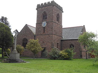
St Chad's Church
53°10′54″N2°31′30″W / 53.1818°N 2.5249°W
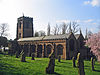
 / 53.1818; -2.5249 (St Chad's Church)
St Chad's Church, Over 2.jpg
14th century (probable)Constructed in sandstone, the church was remodelled in 1543. Restorations and additions were made in 1829, 1868–78, 1897–98, 1904–05, and 1926. Most of the church, including the west tower, is in Perpendicular style, except for the east window, which is in Decorated style. [2] [3] II*
Cross base,
St Chad's Church
53°10′54″N2°31′29″W / 53.18161°N 2.52484°W
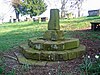
 / 53.18161; -2.52484 (Cross base, St Chad's Church)
St Chad's Church, Over sundial.jpg
c. 1543In yellow sandstone, this consists of a stepped octagonal base carrying a truncated section of a cross shaft. It has been converted into use as a sundial, and is a scheduled monument. [4] [5] II
Littler Grange
53°11′37″N2°33′12″W / 53.1937°N 2.5532°W / 53.1937; -2.5532 (Littler Grange)
Late 16th centuryThe original part of the house is timber-framed with painted wattle and daub infill on a sandstone plinth. To this a brick extension was added in the 19th century. Both parts are in two storeys, and the roofs are slated. The upper storey of the older part is jettied, with a jettied gable. The windows are casements. [6] II
Catsclough Cottage
53°12′12″N2°32′19″W / 53.2033°N 2.5385°W / 53.2033; -2.5385 (Catsclough Cottage)
17th centuryThe original part is timber-framed with brick infill. It is in a single storey with an attic. On the right is a larger 20th-century extension in brick with two storeys. The roofs are slated or tiled. [7] II
246 Delamere Street
53°11′40″N2°33′01″W / 53.1945°N 2.5504°W / 53.1945; -2.5504 (246 Delamere Street)
Mid to late 17th centuryA timber-framed house with rendered infill and some wattle and daub. The house is in two storeys, and has a tiled roof. There have been additions in the 18th and 20th centuries. On the ground floor are two bowed oriel windows, and in the upper floor are three gabled dormers. [8] II
Knights Grange Public House
53°11′58″N2°32′23″W / 53.1995°N 2.5398°W / 53.1995; -2.5398 (Knights Grange Public House)
Mid to late 17th centuryOriginating as a house owned by Vale Royal Abbey, it was later converted into a public house. It is constructed in brick with a slate roof. The building is in two storeys, and has an E-shaped plan. [9] II
Dawk House
53°11′15″N2°32′16″W / 53.1876°N 2.5377°W / 53.1876; -2.5377 (Dawk House)
1717A timber-framed house on a projecting plinth. The front and sides of the house are almost completely rendered; the back has rendered infill. The house is in two storeys and has three bays. The right bay projects forward and is gabled. The windows are casements. [10] II
Barn, Knights Grange Recreation Centre
53°11′59″N2°32′26″W / 53.1997°N 2.5405°W / 53.1997; -2.5405 (Barn, Knights Grange)
Early to mid 18th centuryThis originated as a barn owned by Vale Royal Abbey, which was later converted into a sports centre. It is a brick building with a slate roof in two storeys. Some features, including loft doors and vents of various shapes, have been retained. [11] II
Wharton Hall
53°11′59″N2°30′30″W / 53.1998°N 2.5084°W / 53.1998; -2.5084 (Wharton Hall)
Mid 18th centuryThis originated as a house, later used as a nursing home. It is constructed in rendered brick with a slate roof. The house is in two storeys, and has a double depth plan. The doorway is flanked by 34 columns and has a fanlight. The windows are sashes. There are later extension on both sides of the house. [12] II
Old Vicarage
53°10′48″N2°31′47″W / 53.1801°N 2.5297°W / 53.1801; -2.5297 (Old Vicarage)
Late 18th to early 19th centuryA brick house with a slate roof, in two storeys with a basement and attic. The front is symmetrical with three bays. The central bay projects forward and contains a round-arched doorway and a fanlight. At its top is a pediment containing a Diocletian window. [13] II
Woodford Hall
53°10′48″N2°33′32″W / 53.1801°N 2.5589°W / 53.1801; -2.5589 (Woodford Hall)
Woodford Hall, Winsford.jpg
Late 18th to early 19th centuryA farmhouse in brick on a stone plinth with ashlar dressings and a slate roof. It is in three storeys, and has a symmetrical entrance front in three bays. There is a central doorway with a porch carried on Tuscan columns. Most of the windows are sashes. [14] II
Gatepiers and churchyard walls, St Chad's Church
53°10′54″N2°31′31″W / 53.18163°N 2.52539°W / 53.18163; -2.52539 (Gatepiers and churchyard walls)
1810The walls and gatepiers are in red sandstone ashlar. The 19th-century gates are in cast iron, and the 20th-century overthrow is in wrought iron. A metal plaque carries an inscription and the date. [15] II
80 Wharton Road
53°11′41″N2°30′39″W / 53.1947°N 2.5108°W / 53.1947; -2.5108 (80 Wharton Road)
Early 19th centuryA brick house with a slate roof, in two storeys. The front is in three bays with a central doorway. In front of the house is a glazed verandah with cast iron supports. Between the upper floor windows are pilaster buttresses. On each side of the house is a two-storey bow window with a semi-conical roof. The other windows are sashes. [16] II
Hughes Bridge
53°11′04″N2°28′32″W / 53.18431°N 2.47549°W / 53.18431; -2.47549 (Hughes Bridge)
Hughes Bridge, Winsford.jpg
1827–33An accommodation bridge crossing the Middlewich Branch of the Shropshire Union Canal providing access to Park Farm. Designed by Thomas Telford, it is in brick with a stone band and coping. [17] II
Cross, base and lock-up
53°11′29″N2°32′36″W / 53.19143°N 2.54337°W / 53.19143; -2.54337 (Cross, base and lock-up)
c. 1830 (probable)Constructed in yellow sandstone ashlar, the cross base is very large, and accommodated the local lock-up. On the front are nine steps and a blocked doorway. It carries a small, undecorated cross. [18] [19] II
St John's Church
53°11′32″N2°32′53″W / 53.1922°N 2.5481°W / 53.1922; -2.5481 (St John's Church)
St John's Church, Over.jpg
1860–63A church designed by John Douglas for Lord Delamere. It is constructed in sandstone with a slate roof, and is in Gothic Revival style. At the southwest corner is a steeple with three clock faces and lucarnes. [20] [21] II
Congregational Church
53°11′18″N2°32′24″W / 53.1884°N 2.5399°W / 53.1884; -2.5399 (Congregational Church)
United Reform Church, Over.jpg
1864–65Designed by John Douglas, the church is built in polychromatic brick arranged in alternating red and white bands on a blue plinth, and with diapering. The roof has polychromatic slates. Other features include a two-column loggia carved with depictions of Luther and Calvin, and gabled turrets. [22] [23] II
Memorial
53°11′33″N2°32′53″W / 53.19248°N 2.54796°W / 53.19248; -2.54796 (Memorial)
1874A memorial in the churchyard of St John's Church to those who died as a result of the fire at the Over Cotton Mill. It is in yellow sandstone ashlar, standing on a square plinth. Above this is a square body with an octagonal top including gables and a cross. It is inscribed with a text and the four names of those who died. [24] II
Verdin Technical School
53°11′35″N2°31′50″W / 53.1930°N 2.5306°W / 53.1930; -2.5306 (Verdin Technical School)
Guildhall, Winsford, Cheshire.jpg
1895The technical school was paid for by Sir Joseph Verdin, salt manufacturer, and designed by Messrs Woodhouse and Willoughby, Architects, of Manchester and constructed by Messrs James Fowles and Sons of Winsford. [25] It is a school building in red brick with ashlar dressings, terracotta decoration, and a tile roof. It is in two storeys with an attic. The entrance front has three wide bays, with a lower wing on each side. Its features include shaped gables, and winged lions as finials. [18] [26] II
Brunner Guildhall
53°11′34″N2°31′53″W / 53.1929°N 2.5313°W
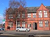
 / 53.1929; -2.5313 (Brunner Guildhall)
Brunner Guildhall, Winsford - geograph.org.uk - 1711473.jpg
1899Designed by A. E. Powles of Northwich, the hall was given to the town by Sir John Brunner. It is constructed in brick with terracotta dressings and a slate roof. It has an almost symmetrical front in eight bays. There are shaped gables on each end and over the half-dormers. [18] [27] II
Boer War Memorial
53°11′30″N2°31′45″W / 53.19161°N 2.52916°W / 53.19161; -2.52916 (Boer War Memorial)
Boer War Memorial in Winsford Cross Shopping Centre - geograph.org.uk - 1711499.jpg
1906A memorial to those who served in the Boer War. It consists of a yellow sandstone base, with a grey granite plinth carrying the white marble statue of a soldier in battledress. It contains inscriptions, including the names of those who died and those who survived. [28] [29] II
Primary School
53°11′35″N2°31′48″W / 53.1931°N 2.5299°W / 53.1931; -2.5299 (Primary School)
1906Built as a primary school, now part of a secondary school. It is a brick building with ashlar dressings and a slate roof. It is in a single storey, and the middle three bays project forward. They are surmounted by a gable with ball finials, and contain four pilaster buttresses. [18] [30] II
War memorial, St Chad's Church
53°10′53″N2°31′32″W / 53.18151°N 2.52556°W / 53.18151; -2.52556 (War Memorial, St Chad's Church)
1918The war memorial stands at the entrance to the churchyard. It is in stone, and consists of a Latin cross with carved decoration at the ends and a decorative collar. This is on a tapering octagonal shaft with a moulded foot, and below is a square plinth with a moulded foot on a base of two steps. There are inscriptions and the names of those lost in the First World War on the plinth and the base. Around the memorial is a gravelled area with stone kerbs. [31] II
War Memorial,
Congregational Church
53°11′19″N2°32′23″W / 53.18863°N 2.53973°W / 53.18863; -2.53973 (War Memorial, Congregational Church)
1920The war memorial stands outside the church, it is in yellow sandstone ashlar with granite plaques. The base supports a square block carrying a cast iron lamp stand and a hexagonal lantern. The lamp stand is decorated with foliage and twisted ladder supports. The plaques bear inscriptions and the names of those who died in both World Wars. [32] II
Wharton War Memorial
53°11′43″N2°30′21″W / 53.19539°N 2.50590°W / 53.19539; -2.50590 (Wharton War Memorial)
1920The war memorial is in the churchyard of Christ Church. It is about 5 metres (16 ft) tall, constructed in Darley stone and timber, and consists of a hooded Calvary. The wooden carved Crucifixion scene is on a slender octagonal shaft. The shaft rises from a low stone octagonal pedestal on a large stone octagonal plinth, which stands on a base of three steps. There are inscriptions on the pedestal and the plinth, and the names of those lost are on the plinth. [33] II

Related Research Articles

<span class="mw-page-title-main">Winsford</span> Town in Cheshire, England

Winsford is a town and civil parish in the unitary authority of Cheshire West and Chester and the ceremonial county of Cheshire, England, on the River Weaver south of Northwich and west of Middlewich. It grew around the salt mining industry after the river was canalised in the 18th century, allowing freight to be conveyed northwards to the Port of Runcorn on the River Mersey. The town of Winsford has an estimated population of 35,500 in 2024.

Farndon is a civil parish in Cheshire West and Chester, England. It contains 19 buildings that are recorded in the National Heritage List for England as designated listed buildings. One of these is listed at Grade I, the highest grade, three at the middle grade, Grade II*, and the rest at the lowest grade, Grade II. Apart from the village of Farndon, the parish is rural. The listed buildings include houses in the village, the church and tombs in the churchyard, the ancient bridge crossing the River Dee, the former village lock-up, and a memorial.

<span class="mw-page-title-main">St Mary's Church, Weaverham</span> Church in Cheshire, England

St Mary's Ecumenical Church is a Church of England / Methodist Local Ecumenical Project in the village of Weaverham, Cheshire, England. The church is the parish church of Weaverham and Acton Bridge and part of the Methodist Northwich and Winsford Circuit. The vision of the church is to share the light and hope of Jesus with the local community. The church building is recorded in the National Heritage List for England as a designated Grade I listed building. It is an active Anglican parish church in the Diocese of Chester, the archdeaconry of Chester and the deanery of Middlewich.

<span class="mw-page-title-main">St Chad's Church, Over</span> Church in Cheshire, England

St Chad's Church, Over, is in the town of Winsford, Cheshire, England. It was formerly in the separate town of Over, but with the growth of Winsford it has become part of that town. The church is recorded in the National Heritage List for England as a designated Grade II* listed building. It is an active Anglican parish church in the diocese of Chester, the archdeaconry of Chester and the deanery of Middlewich.

<span class="mw-page-title-main">St John the Evangelist's Church, Winsford</span> Church in Cheshire, England

St John the Evangelist's Church is in Over, Winsford, Cheshire, England. The church is recorded in the National Heritage List for England as a designated Grade II listed building. It is an active Anglican parish church in the diocese of Chester, the archdeaconry of Chester and the deanery of Middlewich.

Weaverham is a civil parish in Cheshire West and Chester, England. Apart from the village of Weaverham, the parish is entirely rural, and contains 22 buildings that are recorded in the National Heritage List for England as designated listed buildings. Most of the buildings are related to houses or farming, and many of the cottages originating in the 17th century are basically timber-framed. Buildings in other categories are two churches, a public house, and the former grammar school.

Northwich is a civil parish and a town in Cheshire West and Chester, England. It contains 35 buildings that are recorded in the National Heritage List for England as designated listed buildings. Two of these are listed at Grade I, the highest grade, and the rest at the lowest grade, Grade II; none are listed at the middle grade, Grade II*. The River Dane joins the River Weaver and the Weaver Navigation within the parish. Also passing through the parish are the A533 road, the Trent and Mersey Canal, and a railway built by the Cheshire Lines Committee. Many of the listed buildings are associated with these features.

Little Budworth is a civil parish in Cheshire West and Chester, England. It contains 18 buildings that are recorded in the National Heritage List for England as designated listed buildings. Of these, four are listed at Grade II*, and the others at Grade II. Other than the village of Little Budworth, the parish is completely rural, and this is reflected in its listed buildings. These are all domestic or related to farming, other than the village church, a memorial, the entrance gates to the former Oulton Park House, a pinfold, and the plague stone.

Whitegate and Marton is a civil parish in Cheshire West and Chester, England. It contains 33 buildings that are recorded in the National Heritage List for England as designated listed buildings. One of these, Vale Royal Abbey is listed at Grade II*, and the others are at Grade II. The parish is almost entirely rural, and most of the listed buildings are domestic or related to farming. The older houses and cottages are frequently wholly or partly timber-framed. The River Weaver and the Weaver Navigation run through the parish, and some of the listed structures are related to these waterways. Other listed buildings in the parish include ancient stones, monuments, structures related to Vale Royal Abbey, and St Mary's Church, Whitegate, its gatepiers, and its lychgate.

Moulton is a civil parish in Cheshire West and Chester, England. It contains three buildings that are recorded in the National Heritage List for England as designated listed buildings, all of which are at Grade II. This grade is the lowest of the three gradings given to listed buildings and is applied to "buildings of national importance and special interest". The listed buildings all date from the 19th and 20th centuries.

Barrow is a civil parish in Cheshire West and Chester, England. It contains 13 buildings that are recorded in the National Heritage List for England as designated listed buildings. Other than the settlements of Great Barrow and Little Barrow, the parish is entirely rural. Apart from the church, a sundial, and a war memorial, all the listed buildings are domestic or related to farming.

There are over 20,000 Grade II* listed buildings in England. This page is a list of these buildings in the unitary authority of Cheshire West and Chester.

There are over 9,000 Grade I listed buildings in England. This page is a list of these buildings in the unitary authority of Cheshire West and Chester.

Tarvin is a civil parish in Cheshire West and Chester, England. It contains 27 buildings that are recorded in the National Heritage List for England as designated listed buildings. Of these, one is listed at Grade I, the highest grade, two are listed at Grade II*, the middle grade, and the others are at Grade II. The parish contains the village of Tarvin, and is otherwise rural. The listed buildings include the village church and structures in the churchyard, houses, cottages, a shop, a war memorial, and a public house. Outside the village they are houses and farmhouses.

Waverton is a civil parish in Cheshire West and Chester, England. It contains 17 buildings that are recorded in the National Heritage List for England as designated listed buildings. Of these, one is listed at Grade II*, the middle grade, and the others are at Grade II. Apart from the village of Waverton, the parish is rural. Passing through the parish is the Shropshire Union Canal, and three of the bridges crossing this are listed. The other listed buildings in the parish include the parish church, a sundial in the churchyard and the churchyard walls, a former steam mill, a former railway station and goods shed, a former school, a former institute, and a war memorial, together with houses and cottages.

Middlewich is a town within the unitary authority of Cheshire East, England. It contains 41 buildings that are recorded in the National Heritage List for England as designated listed buildings. Of these, two are listed at Grade II*, the middle grade, and the others are at Grade II. The history of the area goes back to the Roman era when it was important for the production of salt. The salt industry in the region has continued since then, but it is not reflected in its listed buildings, other than by the canals. The Trent and Mersey Canal was opened in 1777, and the listed buildings associated with it consist of locks, mileposts, and other buildings and structures. The Middlewich Branch of the Shropshire Union Canal dates from 1829, and the listed buildings associated with this include aqueducts, locks, bridges, and a lock keeper's house. Otherwise, the listed buildings in the town are those usually found in towns, including a church with a sundial in the churchyard, houses, shops, a war memorial and a former mill. Outside the town, the area is rural, and the listed buildings include farmhouses and farm buildings.

Warmingham is a civil parish in Cheshire East, England. It contains eight buildings that are recorded in the National Heritage List for England as designated listed buildings. Of these, two are listed at Grade II*, the middle of the three grades, and the others are at Grade II. Apart from the village of Warmingham, the parish is rural. The listed buildings consist of houses, a church, a medieval cross base, a bridge, and a telephone kiosk.

Manchester is a city in Northwest England. The M8 postcode area is to the north of the city centre, and contains the districts of Cheetham Hill and Crumpsall. This postcode area contains 21 listed buildings that are recorded in the National Heritage List for England. Of these, two are listed at Grade II*, the middle of the three grades, and the others are at Grade II, the lowest grade. The area is residential, and the listed buildings include churches and associated structures, houses, former civic buildings, two museums, a bandstand, a park shelter, a former billiard hall, and two war memorials.

References

Citations

  1. Listed Buildings, Historic England , retrieved 3 April 2015
  2. Hartwell et al. (2011), pp. 679–680
  3. Historic England, "Church of St Chad, Winsford (1139180)", National Heritage List for England , retrieved 22 February 2013
  4. Historic England, "Cross base in churchyard of St Chad, Winsford (1310386)", National Heritage List for England, retrieved 22 February 2013
  5. Historic England, "Standing cross in the churchyard of St Chad's Church, Over, 10m from the south wall of the chancel, Winsford (1013782)", National Heritage List for England, retrieved 22 February 2013
  6. Historic England, "Littler Grange, Winsford (1160816)", National Heritage List for England, retrieved 22 February 2013
  7. Historic England, "Catsclough Cottage, Winsford (1139217)", National Heritage List for England, retrieved 22 February 2013
  8. Historic England, "246 Delamere Street, Winsford (1139216)", National Heritage List for England, retrieved 22 February 2013
  9. Historic England, "Knight Grange Public House, Winsford (1329819)", National Heritage List for England, retrieved 22 February 2013
  10. Historic England, "Dawk House, Winsford (1310382)", National Heritage List for England, retrieved 22 February 2013
  11. Historic England, "Barn at Knights Grange recreation centre, Winsford (1310396)", National Heritage List for England, retrieved 22 February 2013
  12. Historic England, "Wharton Hall, Winsford (1139190)", National Heritage List for England, retrieved 22 February 2013
  13. Historic England, "The Old Vicarage, Winsford (1139179)", National Heritage List for England, retrieved 22 February 2013
  14. Historic England, "Woodford Hall, Winsford (1160943)", National Heritage List for England, retrieved 22 February 2013
  15. Historic England, "Churchyard walls and gatepiers at Church of St Chad, Winsford (1329844)", National Heritage List for England, retrieved 22 February 2013
  16. Historic England, "80 Wharton Road, Winsford (1139185)", National Heritage List for England, retrieved 22 February 2013
  17. Historic England, "Middlewich Branch Canal Hughes Bridge, Winsford (1261168)", National Heritage List for England, retrieved 22 February 2013
  18. 1 2 3 4 Hartwell et al. (2011), p. 681
  19. Historic England, "Cross, base and lock-up, Winsford (1310425)", National Heritage List for England, retrieved 22 February 2013
  20. Hartwell et al. (2011), p. 680
  21. Historic England, "Church of St John the Evangelist, Winsford (1329818)", National Heritage List for England, retrieved 22 February 2013
  22. Hartwell et al. (2011), pp. 680–681
  23. Historic England, "The Congregational Church, Winsford (1160821)", National Heritage List for England, retrieved 22 February 2013
  24. Historic England, "Monument c. 20 yards to North of Church of St John the Evangelist, Winsford (1160760)", National Heritage List for England, retrieved 22 February 2013
  25. David Cogger (1995). Verdin School Winsford 1895 -1995. Verdin High School. ISBN   0-9523370-0-2.
  26. Historic England, "Verdin Building, Winsford (1139218)", National Heritage List for England, retrieved 22 February 2013
  27. Historic England, "Brunner Guildhall, Winsford (1310409)", National Heritage List for England, retrieved 22 February 2013
  28. Hartwell et al. (2011), p. 682
  29. Historic England, "War Memorial, Winsford (1310406)", National Heritage List for England, retrieved 22 February 2013
  30. Historic England, "Old Primary School block at Verdin Comprehensive School, Winsford (1329842)", National Heritage List for England, retrieved 22 February 2013
  31. Historic England, "Winsford War Memorial (1450264)", National Heritage List for England, retrieved 10 November 2017
  32. Historic England, "War Memorial c 15 yards to East of The Congregational Church, Winsford (1329843)", National Heritage List for England, retrieved 22 February 2013
  33. Historic England, "Wharton War Memorial, Winsford (1437121)", National Heritage List for England, retrieved 2 September 2016

Sources